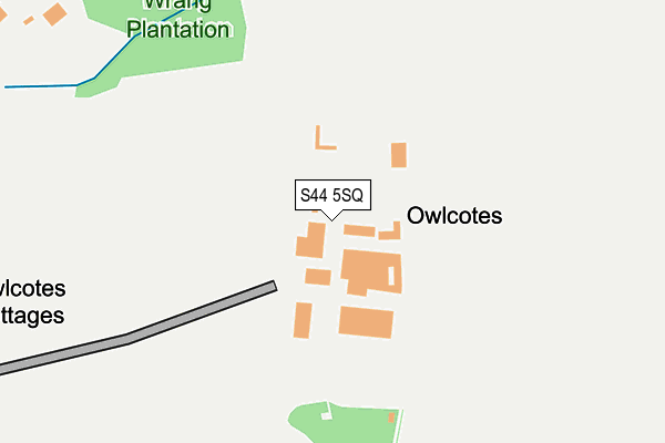
S44 5SQ lies on Shire Lane in Heath, Chesterfield. S44 5SQ is located in the Holmewood & Heath electoral ward, within the local authority district of North East Derbyshire and the English Parliamentary constituency of Bolsover. The Sub Integrated Care Board (ICB) Location is NHS Derby and Derbyshire ICB - 15M and the police force is Derbyshire. This postcode has been in use since January 1980.


GetTheData
Source: OS OpenMap – Local (Ordnance Survey)
Source: OS VectorMap District (Ordnance Survey)
Licence: Open Government Licence (requires attribution)
| Easting | 443696 |
| Northing | 367543 |
| Latitude | 53.203190 |
| Longitude | -1.347289 |
GetTheData
Source: Open Postcode Geo
Licence: Open Government Licence
| Street | Shire Lane |
| Locality | Heath |
| Town/City | Chesterfield |
| Country | England |
| Postcode District | S44 |
➜ See where S44 is on a map | |
GetTheData
Source: Land Registry Price Paid Data
Licence: Open Government Licence
Elevation or altitude of S44 5SQ as distance above sea level:
| Metres | Feet | |
|---|---|---|
| Elevation | 140m | 459ft |
Elevation is measured from the approximate centre of the postcode, to the nearest point on an OS contour line from OS Terrain 50, which has contour spacing of ten vertical metres.
➜ How high above sea level am I? Find the elevation of your current position using your device's GPS.
GetTheData
Source: Open Postcode Elevation
Licence: Open Government Licence
| Ward | Holmewood & Heath |
| Constituency | Bolsover |
GetTheData
Source: ONS Postcode Database
Licence: Open Government Licence
| Shire Lane End (Shire Lane) | Heath | 403m |
| Shire Lane End (Shire Lane) | Heath | 420m |
| Slack Lane End (Slack Lane) | Heath | 434m |
| Slack Lane End (Slack Lane) | Heath | 448m |
| Slack Lane Moorland (Slack Lane) | Heath | 726m |
| Chesterfield Station | 6.2km |
GetTheData
Source: NaPTAN
Licence: Open Government Licence
| Percentage of properties with Next Generation Access | 100.0% |
| Percentage of properties with Superfast Broadband | 0.0% |
| Percentage of properties with Ultrafast Broadband | 0.0% |
| Percentage of properties with Full Fibre Broadband | 0.0% |
Superfast Broadband is between 30Mbps and 300Mbps
Ultrafast Broadband is > 300Mbps
| Percentage of properties unable to receive 2Mbps | 0.0% |
| Percentage of properties unable to receive 5Mbps | 0.0% |
| Percentage of properties unable to receive 10Mbps | 0.0% |
| Percentage of properties unable to receive 30Mbps | 100.0% |
GetTheData
Source: Ofcom
Licence: Ofcom Terms of Use (requires attribution)
GetTheData
Source: ONS Postcode Database
Licence: Open Government Licence


➜ Get more ratings from the Food Standards Agency
GetTheData
Source: Food Standards Agency
Licence: FSA terms & conditions
| Last Collection | |||
|---|---|---|---|
| Location | Mon-Fri | Sat | Distance |
| 42 Heather Avenue | 16:00 | 10:45 | 954m |
| Heath Post Office | 16:00 | 10:45 | 1,305m |
| Sutton Scarsdale | 16:00 | 10:00 | 1,305m |
GetTheData
Source: Dracos
Licence: Creative Commons Attribution-ShareAlike
The below table lists the International Territorial Level (ITL) codes (formerly Nomenclature of Territorial Units for Statistics (NUTS) codes) and Local Administrative Units (LAU) codes for S44 5SQ:
| ITL 1 Code | Name |
|---|---|
| TLF | East Midlands (England) |
| ITL 2 Code | Name |
| TLF1 | Derbyshire and Nottinghamshire |
| ITL 3 Code | Name |
| TLF12 | East Derbyshire |
| LAU 1 Code | Name |
| E07000038 | North East Derbyshire |
GetTheData
Source: ONS Postcode Directory
Licence: Open Government Licence
The below table lists the Census Output Area (OA), Lower Layer Super Output Area (LSOA), and Middle Layer Super Output Area (MSOA) for S44 5SQ:
| Code | Name | |
|---|---|---|
| OA | E00100198 | |
| LSOA | E01019799 | North East Derbyshire 009C |
| MSOA | E02004113 | North East Derbyshire 009 |
GetTheData
Source: ONS Postcode Directory
Licence: Open Government Licence
| S44 5SF | Mansfield Road | 538m |
| S44 5QX | Moorland Drive | 800m |
| S44 5QY | Moorland Drive | 818m |
| S44 5QZ | Lilac Close | 856m |
| S44 5QU | Slack Lane | 921m |
| S44 5SE | Mansfield Road | 967m |
| S44 5SB | Mansfield Road | 973m |
| S44 5RG | Bramble Close | 1035m |
| S44 5RD | Bracken Avenue | 1045m |
| S44 5RF | Heather Avenue | 1055m |
GetTheData
Source: Open Postcode Geo; Land Registry Price Paid Data
Licence: Open Government Licence