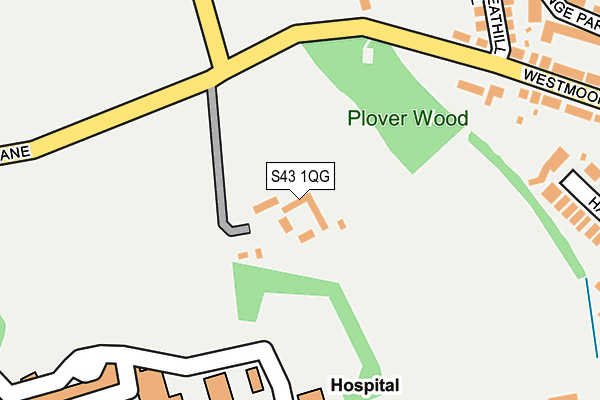
S43 1QG is in Brimington, Chesterfield. S43 1QG is located in the Spire electoral ward, within the local authority district of Chesterfield and the English Parliamentary constituency of Chesterfield. The Sub Integrated Care Board (ICB) Location is NHS Derby and Derbyshire ICB - 15M and the police force is Derbyshire. This postcode has been in use since January 1980.


GetTheData
Source: OS OpenMap – Local (Ordnance Survey)
Source: OS VectorMap District (Ordnance Survey)
Licence: Open Government Licence (requires attribution)
| Easting | 440502 |
| Northing | 371555 |
| Latitude | 53.239485 |
| Longitude | -1.394597 |
GetTheData
Source: Open Postcode Geo
Licence: Open Government Licence
| Locality | Brimington |
| Town/City | Chesterfield |
| Country | England |
| Postcode District | S43 |
➜ See where S43 is on a map | |
GetTheData
Source: Land Registry Price Paid Data
Licence: Open Government Licence
Elevation or altitude of S43 1QG as distance above sea level:
| Metres | Feet | |
|---|---|---|
| Elevation | 130m | 427ft |
Elevation is measured from the approximate centre of the postcode, to the nearest point on an OS contour line from OS Terrain 50, which has contour spacing of ten vertical metres.
➜ How high above sea level am I? Find the elevation of your current position using your device's GPS.
GetTheData
Source: Open Postcode Elevation
Licence: Open Government Licence
| Ward | Spire |
| Constituency | Chesterfield |
GetTheData
Source: ONS Postcode Database
Licence: Open Government Licence
| Grange Park Avenue (Manor Road) | Brimington Common | 402m |
| Grange Park Avenue (Manor Road) | Brimington Common | 412m |
| Royal Hospital (Bus Station) | Calow | 432m |
| Royal Hospital (Bus Station) | Calow | 442m |
| Barry Road (Manor Road) | Brimington Common | 457m |
| Chesterfield Station | 1.7km |
GetTheData
Source: NaPTAN
Licence: Open Government Licence
| Median download speed | 44.0Mbps |
| Average download speed | 47.3Mbps |
| Maximum download speed | 70.75Mbps |
| Median upload speed | 10.0Mbps |
| Average upload speed | 12.5Mbps |
| Maximum upload speed | 18.20Mbps |
GetTheData
Source: Ofcom
Licence: Ofcom Terms of Use (requires attribution)
Estimated total energy consumption in S43 1QG by fuel type, 2015.
| Consumption (kWh) | 78,489 |
|---|---|
| Meter count | 9 |
| Mean (kWh/meter) | 8,721 |
| Median (kWh/meter) | 4,329 |
GetTheData
Source: Postcode level gas estimates: 2015 (experimental)
Source: Postcode level electricity estimates: 2015 (experimental)
Licence: Open Government Licence
GetTheData
Source: ONS Postcode Database
Licence: Open Government Licence


➜ Get more ratings from the Food Standards Agency
GetTheData
Source: Food Standards Agency
Licence: FSA terms & conditions
| Last Collection | |||
|---|---|---|---|
| Location | Mon-Fri | Sat | Distance |
| Hathern Close | 16:00 | 10:15 | 379m |
| Allpits Road | 16:00 | 10:15 | 540m |
| The Post Office | 16:00 | 10:15 | 769m |
GetTheData
Source: Dracos
Licence: Creative Commons Attribution-ShareAlike
The below table lists the International Territorial Level (ITL) codes (formerly Nomenclature of Territorial Units for Statistics (NUTS) codes) and Local Administrative Units (LAU) codes for S43 1QG:
| ITL 1 Code | Name |
|---|---|
| TLF | East Midlands (England) |
| ITL 2 Code | Name |
| TLF1 | Derbyshire and Nottinghamshire |
| ITL 3 Code | Name |
| TLF12 | East Derbyshire |
| LAU 1 Code | Name |
| E07000034 | Chesterfield |
GetTheData
Source: ONS Postcode Directory
Licence: Open Government Licence
The below table lists the Census Output Area (OA), Lower Layer Super Output Area (LSOA), and Middle Layer Super Output Area (MSOA) for S43 1QG:
| Code | Name | |
|---|---|---|
| OA | E00099040 | |
| LSOA | E01019585 | Chesterfield 012G |
| MSOA | E02004066 | Chesterfield 012 |
GetTheData
Source: ONS Postcode Directory
Licence: Open Government Licence
| S43 1PU | Wheathill Close | 288m |
| S43 1PT | Westmoor Road | 294m |
| S43 1PS | Hathern Close | 326m |
| S43 1PN | Grange Park Avenue | 345m |
| S44 5AZ | Tapton Way | 381m |
| S43 1PX | Barry Road | 383m |
| S43 1PZ | Melville Crescent | 421m |
| S43 1PY | Southmoor Close | 424m |
| S43 1PP | Manor Road | 435m |
| S44 5AX | Parker Avenue | 443m |
GetTheData
Source: Open Postcode Geo; Land Registry Price Paid Data
Licence: Open Government Licence