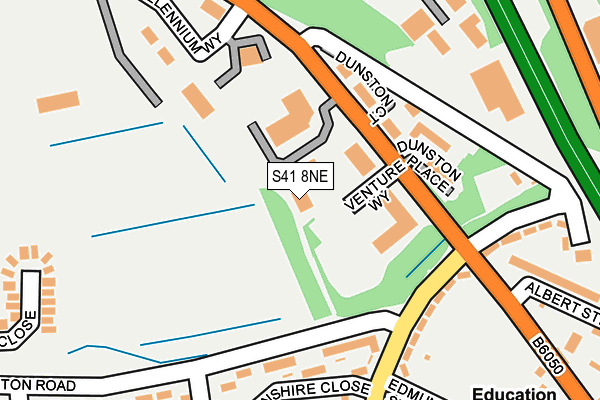
S41 8NE lies on Dunston Road in Chesterfield. S41 8NE is located in the Dunston electoral ward, within the local authority district of Chesterfield and the English Parliamentary constituency of Chesterfield. The Sub Integrated Care Board (ICB) Location is NHS Derby and Derbyshire ICB - 15M and the police force is Derbyshire. This postcode has been in use since June 2002.


GetTheData
Source: OS OpenMap – Local (Ordnance Survey)
Source: OS VectorMap District (Ordnance Survey)
Licence: Open Government Licence (requires attribution)
| Easting | 437617 |
| Northing | 374134 |
| Latitude | 53.262896 |
| Longitude | -1.437516 |
GetTheData
Source: Open Postcode Geo
Licence: Open Government Licence
| Street | Dunston Road |
| Town/City | Chesterfield |
| Country | England |
| Postcode District | S41 |
➜ See where S41 is on a map ➜ Where is Chesterfield? | |
GetTheData
Source: Land Registry Price Paid Data
Licence: Open Government Licence
Elevation or altitude of S41 8NE as distance above sea level:
| Metres | Feet | |
|---|---|---|
| Elevation | 80m | 262ft |
Elevation is measured from the approximate centre of the postcode, to the nearest point on an OS contour line from OS Terrain 50, which has contour spacing of ten vertical metres.
➜ How high above sea level am I? Find the elevation of your current position using your device's GPS.
GetTheData
Source: Open Postcode Elevation
Licence: Open Government Licence
| Ward | Dunston |
| Constituency | Chesterfield |
GetTheData
Source: ONS Postcode Database
Licence: Open Government Licence
| Dunston Road (Racecourse Road) | Newbold | 148m |
| Cutts Shiers (Dunston Road) | Sheepbridge | 153m |
| Dunston Road (Racecourse Road) | Newbold | 160m |
| Cutts Shiers (Dunston Road) | Sheepbridge | 164m |
| Rydal Crescent (Coniston Road) | Newbold | 228m |
| Chesterfield Station | 3km |
| Dronfield Station | 4.8km |
GetTheData
Source: NaPTAN
Licence: Open Government Licence
GetTheData
Source: ONS Postcode Database
Licence: Open Government Licence


➜ Get more ratings from the Food Standards Agency
GetTheData
Source: Food Standards Agency
Licence: FSA terms & conditions
| Last Collection | |||
|---|---|---|---|
| Location | Mon-Fri | Sat | Distance |
| Millennium Way | 16:00 | 09:00 | 194m |
| Millennium Way | 18:30 | 195m | |
| Lindale Road | 16:00 | 11:15 | 474m |
GetTheData
Source: Dracos
Licence: Creative Commons Attribution-ShareAlike
The below table lists the International Territorial Level (ITL) codes (formerly Nomenclature of Territorial Units for Statistics (NUTS) codes) and Local Administrative Units (LAU) codes for S41 8NE:
| ITL 1 Code | Name |
|---|---|
| TLF | East Midlands (England) |
| ITL 2 Code | Name |
| TLF1 | Derbyshire and Nottinghamshire |
| ITL 3 Code | Name |
| TLF12 | East Derbyshire |
| LAU 1 Code | Name |
| E07000034 | Chesterfield |
GetTheData
Source: ONS Postcode Directory
Licence: Open Government Licence
The below table lists the Census Output Area (OA), Lower Layer Super Output Area (LSOA), and Middle Layer Super Output Area (MSOA) for S41 8NE:
| Code | Name | |
|---|---|---|
| OA | E00098836 | |
| LSOA | E01019542 | Chesterfield 004B |
| MSOA | E02004058 | Chesterfield 004 |
GetTheData
Source: ONS Postcode Directory
Licence: Open Government Licence
| S41 8UG | Devonshire Close | 162m |
| S41 8ND | Millennium Way | 226m |
| S41 8NN | Racecourse Road | 234m |
| S41 8UN | Devonshire Close | 246m |
| S41 8JD | Coniston Road | 269m |
| S41 8NT | Arundel Close | 276m |
| S41 8NU | Arundel Close | 286m |
| S41 9RN | Foxwood Industrial Park | 291m |
| S41 8NP | Albert Street North | 304m |
| S41 8JW | Mardale Close | 305m |
GetTheData
Source: Open Postcode Geo; Land Registry Price Paid Data
Licence: Open Government Licence