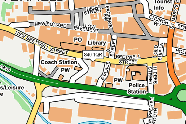
S40 1QR is located in the Spire electoral ward, within the local authority district of Chesterfield and the English Parliamentary constituency of Chesterfield. The Sub Integrated Care Board (ICB) Location is NHS Derby and Derbyshire ICB - 15M and the police force is Derbyshire. This postcode has been in use since January 1980.


GetTheData
Source: OS OpenMap – Local (Ordnance Survey)
Source: OS VectorMap District (Ordnance Survey)
Licence: Open Government Licence (requires attribution)
| Easting | 438177 |
| Northing | 370947 |
| Latitude | 53.234211 |
| Longitude | -1.429502 |
GetTheData
Source: Open Postcode Geo
Licence: Open Government Licence
| Country | England |
| Postcode District | S40 |
➜ See where S40 is on a map ➜ Where is Chesterfield? | |
GetTheData
Source: Land Registry Price Paid Data
Licence: Open Government Licence
Elevation or altitude of S40 1QR as distance above sea level:
| Metres | Feet | |
|---|---|---|
| Elevation | 90m | 295ft |
Elevation is measured from the approximate centre of the postcode, to the nearest point on an OS contour line from OS Terrain 50, which has contour spacing of ten vertical metres.
➜ How high above sea level am I? Find the elevation of your current position using your device's GPS.
GetTheData
Source: Open Postcode Elevation
Licence: Open Government Licence
| Ward | Spire |
| Constituency | Chesterfield |
GetTheData
Source: ONS Postcode Database
Licence: Open Government Licence
| New Beetwell Street | Chesterfield | 19m |
| New Beetwell Street | Chesterfield | 24m |
| Coach Station (Beckingham Way) | Chesterfield | 37m |
| New Beetwell Street | Chesterfield | 37m |
| New Beetwell Street | Chesterfield | 40m |
| Chesterfield Station | 0.8km |
GetTheData
Source: NaPTAN
Licence: Open Government Licence
GetTheData
Source: ONS Postcode Database
Licence: Open Government Licence

➜ Get more ratings from the Food Standards Agency
GetTheData
Source: Food Standards Agency
Licence: FSA terms & conditions
| Last Collection | |||
|---|---|---|---|
| Location | Mon-Fri | Sat | Distance |
| Post Office | 18:30 | 12:00 | 179m |
| Low Pavement | 16:45 | 11:00 | 180m |
| 70 Park Road | 17:15 | 12:00 | 207m |
GetTheData
Source: Dracos
Licence: Creative Commons Attribution-ShareAlike
The below table lists the International Territorial Level (ITL) codes (formerly Nomenclature of Territorial Units for Statistics (NUTS) codes) and Local Administrative Units (LAU) codes for S40 1QR:
| ITL 1 Code | Name |
|---|---|
| TLF | East Midlands (England) |
| ITL 2 Code | Name |
| TLF1 | Derbyshire and Nottinghamshire |
| ITL 3 Code | Name |
| TLF12 | East Derbyshire |
| LAU 1 Code | Name |
| E07000034 | Chesterfield |
GetTheData
Source: ONS Postcode Directory
Licence: Open Government Licence
The below table lists the Census Output Area (OA), Lower Layer Super Output Area (LSOA), and Middle Layer Super Output Area (MSOA) for S40 1QR:
| Code | Name | |
|---|---|---|
| OA | E00173355 | |
| LSOA | E01033387 | Chesterfield 010F |
| MSOA | E02004064 | Chesterfield 010 |
GetTheData
Source: ONS Postcode Directory
Licence: Open Government Licence
| S40 1TA | Markham Road | 61m |
| S40 1XZ | Park Road | 82m |
| S40 1SH | Beetwell Street | 168m |
| S40 1AH | New Square | 184m |
| S40 1RB | Packers Row | 206m |
| S40 1JN | Soresby Street | 221m |
| S40 1TP | Glumangate | 221m |
| S40 2JZ | New Street | 230m |
| S40 2JX | Park Road | 256m |
| S40 2LA | Elton Street | 266m |
GetTheData
Source: Open Postcode Geo; Land Registry Price Paid Data
Licence: Open Government Licence