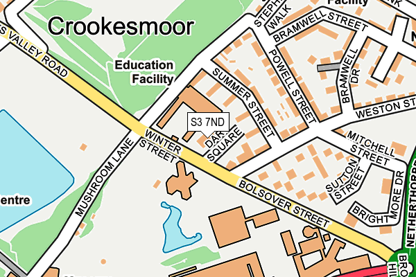
S3 7ND is located in the Walkley electoral ward, within the metropolitan district of Sheffield and the English Parliamentary constituency of Sheffield Central. The Sub Integrated Care Board (ICB) Location is NHS South Yorkshire ICB - 03N and the police force is South Yorkshire. This postcode has been in use since January 1980.


GetTheData
Source: OS OpenMap – Local (Ordnance Survey)
Source: OS VectorMap District (Ordnance Survey)
Licence: Open Government Licence (requires attribution)
| Easting | 434121 |
| Northing | 387556 |
| Latitude | 53.383772 |
| Longitude | -1.488486 |
GetTheData
Source: Open Postcode Geo
Licence: Open Government Licence
| Country | England |
| Postcode District | S3 |
➜ See where S3 is on a map ➜ Where is Sheffield? | |
GetTheData
Source: Land Registry Price Paid Data
Licence: Open Government Licence
Elevation or altitude of S3 7ND as distance above sea level:
| Metres | Feet | |
|---|---|---|
| Elevation | 120m | 394ft |
Elevation is measured from the approximate centre of the postcode, to the nearest point on an OS contour line from OS Terrain 50, which has contour spacing of ten vertical metres.
➜ How high above sea level am I? Find the elevation of your current position using your device's GPS.
GetTheData
Source: Open Postcode Elevation
Licence: Open Government Licence
| Ward | Walkley |
| Constituency | Sheffield Central |
GetTheData
Source: ONS Postcode Database
Licence: Open Government Licence
| Mushroom Lane (Winter Street) | Crookesmoor | 36m |
| Mushroom Lane (Winter Street) | Crookesmoor | 55m |
| Powell Street (Bramwell Street) | Netherthorpe | 181m |
| University (Bolsover Street) | Western Bank | 204m |
| Oxford Street (Crookes Valley Road) | Crookesmoor | 243m |
| Netherthorpe Road (Sheffield Supertram) (Netherthorpe Road) | Netherthorpe | 411m |
| University Of Sheffield (Sheffield Supertram) (Hanover Street) | Western Bank | 451m |
| West Street (Sheffield Supertram) (West Street) | Sheffield Centre | 815m |
| Infirmary Road (Sheffield Supertram) (Infirmary Road) | Upperthorpe | 889m |
| Shalesmoor (Sheffield Supertram) (Corner Of Netherthorpe Rd And Shalesmoor) | Shalesmoor | 890m |
| Sheffield Station | 1.9km |
| Meadowhall Station | 6.3km |
GetTheData
Source: NaPTAN
Licence: Open Government Licence
GetTheData
Source: ONS Postcode Database
Licence: Open Government Licence


➜ Get more ratings from the Food Standards Agency
GetTheData
Source: Food Standards Agency
Licence: FSA terms & conditions
| Last Collection | |||
|---|---|---|---|
| Location | Mon-Fri | Sat | Distance |
| Mushroom Lane | 17:30 | 10:00 | 113m |
| Bolsover Street | 17:30 | 12:00 | 181m |
| Western Bank | 18:00 | 09:30 | 264m |
GetTheData
Source: Dracos
Licence: Creative Commons Attribution-ShareAlike
The below table lists the International Territorial Level (ITL) codes (formerly Nomenclature of Territorial Units for Statistics (NUTS) codes) and Local Administrative Units (LAU) codes for S3 7ND:
| ITL 1 Code | Name |
|---|---|
| TLE | Yorkshire and The Humber |
| ITL 2 Code | Name |
| TLE3 | South Yorkshire |
| ITL 3 Code | Name |
| TLE32 | Sheffield |
| LAU 1 Code | Name |
| E08000019 | Sheffield |
GetTheData
Source: ONS Postcode Directory
Licence: Open Government Licence
The below table lists the Census Output Area (OA), Lower Layer Super Output Area (LSOA), and Middle Layer Super Output Area (MSOA) for S3 7ND:
| Code | Name | |
|---|---|---|
| OA | E00040866 | |
| LSOA | E01008068 | Sheffield 026B |
| MSOA | E02001636 | Sheffield 026 |
GetTheData
Source: ONS Postcode Directory
Licence: Open Government Licence
| S3 7NS | Summer Street | 61m |
| S3 7NT | Summer Street | 96m |
| S3 7NW | Powell Street | 126m |
| S3 7LZ | Yardley Square | 135m |
| S3 7NA | Bolsover Street | 136m |
| S3 7NX | Powell Street | 158m |
| S3 7NQ | Weston Street | 183m |
| S3 7NJ | Mitchell Street | 187m |
| S3 7NE | Sutton Street | 194m |
| S3 7NN | Mitchell Street | 213m |
GetTheData
Source: Open Postcode Geo; Land Registry Price Paid Data
Licence: Open Government Licence