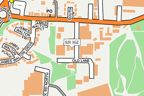
S20 3GZ is located in the Mosborough electoral ward, within the metropolitan district of Sheffield and the English Parliamentary constituency of Sheffield South East. The Sub Integrated Care Board (ICB) Location is NHS South Yorkshire ICB - 03N and the police force is South Yorkshire. This postcode has been in use since June 1997.


GetTheData
Source: OS OpenMap – Local (Ordnance Survey)
Source: OS VectorMap District (Ordnance Survey)
Licence: Open Government Licence (requires attribution)
| Easting | 444025 |
| Northing | 381182 |
| Latitude | 53.325753 |
| Longitude | -1.340483 |
GetTheData
Source: Open Postcode Geo
Licence: Open Government Licence
| Country | England |
| Postcode District | S20 |
➜ See where S20 is on a map ➜ Where is Sheffield? | |
GetTheData
Source: Land Registry Price Paid Data
Licence: Open Government Licence
Elevation or altitude of S20 3GZ as distance above sea level:
| Metres | Feet | |
|---|---|---|
| Elevation | 50m | 164ft |
Elevation is measured from the approximate centre of the postcode, to the nearest point on an OS contour line from OS Terrain 50, which has contour spacing of ten vertical metres.
➜ How high above sea level am I? Find the elevation of your current position using your device's GPS.
GetTheData
Source: Open Postcode Elevation
Licence: Open Government Licence
| Ward | Mosborough |
| Constituency | Sheffield South East |
GetTheData
Source: ONS Postcode Database
Licence: Open Government Licence
| Morrisons (Service Road) | Oxclose | 212m |
| South View (Station Road) | Holbrook | 213m |
| Rotherham Road (Station Road) | Halfway | 251m |
| Eckington Way (Station Road) | Halfway | 288m |
| Meadowbrook Park (Station Road) | Holbrook | 353m |
| Halfway (Sheffield Supertram) (Eckington Way) | Halfway Tram Stop | 403m |
| Westfield (Sheffield Supertram) (Eckington Way) | Westfield | 718m |
| Waterthorpe (Sheffield Supertram) (Eckington Way) | Waterthorpe | 1,234m |
| Woodhouse Station | 4.4km |
| Kiveton Bridge Station | 5.2km |
GetTheData
Source: NaPTAN
Licence: Open Government Licence
GetTheData
Source: ONS Postcode Database
Licence: Open Government Licence


➜ Get more ratings from the Food Standards Agency
GetTheData
Source: Food Standards Agency
Licence: FSA terms & conditions
| Last Collection | |||
|---|---|---|---|
| Location | Mon-Fri | Sat | Distance |
| Station Road | 17:15 | 11:00 | 209m |
| Halfway Delivery Office | 17:15 | 10:30 | 382m |
| Sewell Road | 17:15 | 11:30 | 440m |
GetTheData
Source: Dracos
Licence: Creative Commons Attribution-ShareAlike
The below table lists the International Territorial Level (ITL) codes (formerly Nomenclature of Territorial Units for Statistics (NUTS) codes) and Local Administrative Units (LAU) codes for S20 3GZ:
| ITL 1 Code | Name |
|---|---|
| TLE | Yorkshire and The Humber |
| ITL 2 Code | Name |
| TLE3 | South Yorkshire |
| ITL 3 Code | Name |
| TLE32 | Sheffield |
| LAU 1 Code | Name |
| E08000019 | Sheffield |
GetTheData
Source: ONS Postcode Directory
Licence: Open Government Licence
The below table lists the Census Output Area (OA), Lower Layer Super Output Area (LSOA), and Middle Layer Super Output Area (MSOA) for S20 3GZ:
| Code | Name | |
|---|---|---|
| OA | E00172436 | |
| LSOA | E01008019 | Sheffield 065A |
| MSOA | E02001675 | Sheffield 065 |
GetTheData
Source: ONS Postcode Directory
Licence: Open Government Licence
| S20 3GY | James Walton Court | 215m |
| S20 3GR | South View | 235m |
| S20 3GS | Station Road | 239m |
| S20 3GN | James Walton Drive | 261m |
| S20 3GQ | James Walton View | 273m |
| S20 3GP | James Walton Place | 293m |
| S20 3GT | Station Road | 314m |
| S20 8GR | Oxclose Park Gardens | 341m |
| S20 8GQ | Oxclose Park View | 396m |
| S20 8GL | Rotherham Road | 412m |
GetTheData
Source: Open Postcode Geo; Land Registry Price Paid Data
Licence: Open Government Licence