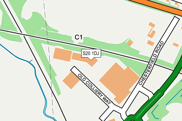
S20 1DJ lies on Old Colliery Way in Beighton, Sheffield. S20 1DJ is located in the Aughton & Swallownest electoral ward, within the metropolitan district of Rotherham and the English Parliamentary constituency of Rother Valley. The Sub Integrated Care Board (ICB) Location is NHS South Yorkshire ICB - 03L and the police force is South Yorkshire. This postcode has been in use since January 2010.


GetTheData
Source: OS OpenMap – Local (Ordnance Survey)
Source: OS VectorMap District (Ordnance Survey)
Licence: Open Government Licence (requires attribution)
| Easting | 444551 |
| Northing | 384563 |
| Latitude | 53.356098 |
| Longitude | -1.332112 |
GetTheData
Source: Open Postcode Geo
Licence: Open Government Licence
| Street | Old Colliery Way |
| Locality | Beighton |
| Town/City | Sheffield |
| Country | England |
| Postcode District | S20 |
➜ See where S20 is on a map | |
GetTheData
Source: Land Registry Price Paid Data
Licence: Open Government Licence
Elevation or altitude of S20 1DJ as distance above sea level:
| Metres | Feet | |
|---|---|---|
| Elevation | 50m | 164ft |
Elevation is measured from the approximate centre of the postcode, to the nearest point on an OS contour line from OS Terrain 50, which has contour spacing of ten vertical metres.
➜ How high above sea level am I? Find the elevation of your current position using your device's GPS.
GetTheData
Source: Open Postcode Elevation
Licence: Open Government Licence
| Ward | Aughton & Swallownest |
| Constituency | Rother Valley |
GetTheData
Source: ONS Postcode Database
Licence: Open Government Licence
| A57 (Chesterfield Road) | Swallownest | 290m |
| A57 (Chesterfield Road) | Swallownest | 299m |
| Park Drive (Chesterfield Road) | Swallownest | 625m |
| Wetherby Drive (Chesterfield Road) | Swallownest | 656m |
| West Park Drive (Sheffield Road) | Swallownest | 754m |
| Woodhouse Station | 1.9km |
| Kiveton Bridge Station | 4.6km |
GetTheData
Source: NaPTAN
Licence: Open Government Licence
| Median download speed | 8.1Mbps |
| Average download speed | 7.0Mbps |
| Maximum download speed | 9.70Mbps |
| Median upload speed | 1.0Mbps |
| Average upload speed | 0.9Mbps |
| Maximum upload speed | 1.07Mbps |
GetTheData
Source: Ofcom
Licence: Ofcom Terms of Use (requires attribution)
GetTheData
Source: ONS Postcode Database
Licence: Open Government Licence


➜ Get more ratings from the Food Standards Agency
GetTheData
Source: Food Standards Agency
Licence: FSA terms & conditions
| Last Collection | |||
|---|---|---|---|
| Location | Mon-Fri | Sat | Distance |
| 16 Alexandra Road | 16:45 | 11:30 | 481m |
| Wetherby Drive | 16:00 | 11:45 | 700m |
| 30 Woodhouse Lane | 16:00 | 12:00 | 795m |
GetTheData
Source: Dracos
Licence: Creative Commons Attribution-ShareAlike
The below table lists the International Territorial Level (ITL) codes (formerly Nomenclature of Territorial Units for Statistics (NUTS) codes) and Local Administrative Units (LAU) codes for S20 1DJ:
| ITL 1 Code | Name |
|---|---|
| TLE | Yorkshire and The Humber |
| ITL 2 Code | Name |
| TLE3 | South Yorkshire |
| ITL 3 Code | Name |
| TLE31 | Barnsley, Doncaster and Rotherham |
| LAU 1 Code | Name |
| E08000018 | Rotherham |
GetTheData
Source: ONS Postcode Directory
Licence: Open Government Licence
The below table lists the Census Output Area (OA), Lower Layer Super Output Area (LSOA), and Middle Layer Super Output Area (MSOA) for S20 1DJ:
| Code | Name | |
|---|---|---|
| OA | E00038854 | |
| LSOA | E01007665 | Rotherham 027A |
| MSOA | E02001604 | Rotherham 027 |
GetTheData
Source: ONS Postcode Directory
Licence: Open Government Licence
| S26 4SY | Thorncliffe Close | 403m |
| S26 4SX | Lidget Close | 425m |
| S26 4SZ | Swallow Wood Road | 492m |
| S26 4SU | Swallow Wood Road | 505m |
| S26 4TL | Chesterfield Road | 539m |
| S26 4NW | Collingham Road | 570m |
| S26 4UY | West Park Drive | 572m |
| S26 4SR | Russell Close | 578m |
| S26 4UL | Park Drive | 600m |
| S20 1AE | Woodhouse Lane | 603m |
GetTheData
Source: Open Postcode Geo; Land Registry Price Paid Data
Licence: Open Government Licence