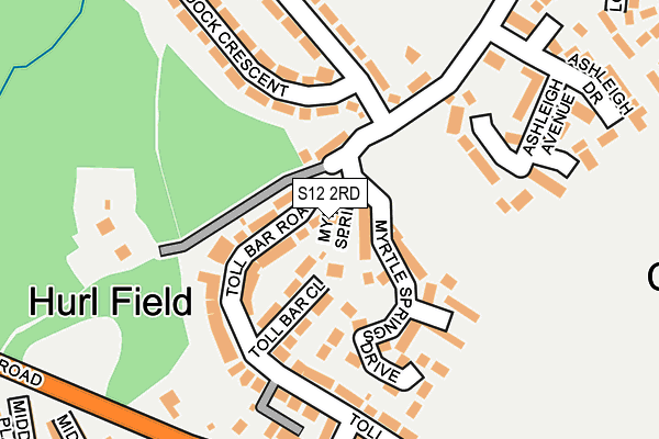
S12 2RD lies on Toll Bar Avenue in Sheffield. S12 2RD is located in the Park and Arbourthorne electoral ward, within the metropolitan district of Sheffield and the English Parliamentary constituency of Sheffield, Heeley. The Sub Integrated Care Board (ICB) Location is NHS South Yorkshire ICB - 03N and the police force is South Yorkshire. This postcode has been in use since January 1980.


GetTheData
Source: OS OpenMap – Local (Ordnance Survey)
Source: OS VectorMap District (Ordnance Survey)
Licence: Open Government Licence (requires attribution)
| Easting | 437503 |
| Northing | 384200 |
| Latitude | 53.353380 |
| Longitude | -1.438039 |
GetTheData
Source: Open Postcode Geo
Licence: Open Government Licence
| Street | Toll Bar Avenue |
| Town/City | Sheffield |
| Country | England |
| Postcode District | S12 |
➜ See where S12 is on a map ➜ Where is Sheffield? | |
GetTheData
Source: Land Registry Price Paid Data
Licence: Open Government Licence
Elevation or altitude of S12 2RD as distance above sea level:
| Metres | Feet | |
|---|---|---|
| Elevation | 200m | 656ft |
Elevation is measured from the approximate centre of the postcode, to the nearest point on an OS contour line from OS Terrain 50, which has contour spacing of ten vertical metres.
➜ How high above sea level am I? Find the elevation of your current position using your device's GPS.
GetTheData
Source: Open Postcode Elevation
Licence: Open Government Licence
| Ward | Park And Arbourthorne |
| Constituency | Sheffield, Heeley |
GetTheData
Source: ONS Postcode Database
Licence: Open Government Licence
| Paddock Crescent (Arbourthorne Road) | Hurlfield | 132m |
| Paddock Crescent (Arbourthorne Road) | Hurlfield | 154m |
| Toll Bar Road (Gleadless Road) | Hurlfield | 231m |
| Ashleigh Drive (Hurlfield Road) | Hurlfield | 249m |
| Ashleigh Drive (Hurlfield Road) | Hurlfield | 251m |
| Hollinsend (Sheffield Supertram) (Ridgeway Road) | Gleadless | 911m |
| Manor Top - Elm Tree (Sheffield Supertram) (Off Ridgeway Road) | Manor Top | 943m |
| Gleadless Townend (Sheffield Supertram) (Ridgeway Road) | Gleadless Townend | 1,147m |
| Herdings Park (Sheffield Supertram) (Off Raeburn Road) | Herdings | 1,220m |
| Herdings - Leighton Road (Sheffield Supertram) (Off Norton Avenue) | Herdings | 1,270m |
| Sheffield Station | 3.2km |
| Darnall Station | 3.9km |
GetTheData
Source: NaPTAN
Licence: Open Government Licence
| Percentage of properties with Next Generation Access | 100.0% |
| Percentage of properties with Superfast Broadband | 100.0% |
| Percentage of properties with Ultrafast Broadband | 100.0% |
| Percentage of properties with Full Fibre Broadband | 0.0% |
Superfast Broadband is between 30Mbps and 300Mbps
Ultrafast Broadband is > 300Mbps
| Percentage of properties unable to receive 2Mbps | 0.0% |
| Percentage of properties unable to receive 5Mbps | 0.0% |
| Percentage of properties unable to receive 10Mbps | 0.0% |
| Percentage of properties unable to receive 30Mbps | 0.0% |
GetTheData
Source: Ofcom
Licence: Ofcom Terms of Use (requires attribution)
GetTheData
Source: ONS Postcode Database
Licence: Open Government Licence


➜ Get more ratings from the Food Standards Agency
GetTheData
Source: Food Standards Agency
Licence: FSA terms & conditions
| Last Collection | |||
|---|---|---|---|
| Location | Mon-Fri | Sat | Distance |
| 166 Gleadless Common | 17:30 | 09:30 | 478m |
| Leighton Road | 17:30 | 09:30 | 486m |
| 2 Bartle Road | 17:30 | 09:30 | 694m |
GetTheData
Source: Dracos
Licence: Creative Commons Attribution-ShareAlike
The below table lists the International Territorial Level (ITL) codes (formerly Nomenclature of Territorial Units for Statistics (NUTS) codes) and Local Administrative Units (LAU) codes for S12 2RD:
| ITL 1 Code | Name |
|---|---|
| TLE | Yorkshire and The Humber |
| ITL 2 Code | Name |
| TLE3 | South Yorkshire |
| ITL 3 Code | Name |
| TLE32 | Sheffield |
| LAU 1 Code | Name |
| E08000019 | Sheffield |
GetTheData
Source: ONS Postcode Directory
Licence: Open Government Licence
The below table lists the Census Output Area (OA), Lower Layer Super Output Area (LSOA), and Middle Layer Super Output Area (MSOA) for S12 2RD:
| Code | Name | |
|---|---|---|
| OA | E00040411 | |
| LSOA | E01007982 | Sheffield 054A |
| MSOA | E02001664 | Sheffield 054 |
GetTheData
Source: ONS Postcode Directory
Licence: Open Government Licence
| S12 2SL | Hurlfield Road | 64m |
| S12 2RB | Toll Bar Close | 99m |
| S12 2RE | Myrtle Springs Drive | 126m |
| S12 2QZ | Toll Bar Road | 136m |
| S12 2RZ | Ashleigh Avenue | 179m |
| S12 2QX | Toll Bar Drive | 192m |
| S2 2AR | Paddock Crescent | 198m |
| S12 2RA | Myrtle Springs | 200m |
| S2 2AQ | Paddock Crescent | 203m |
| S12 2RY | Ashleigh Croft | 204m |
GetTheData
Source: Open Postcode Geo; Land Registry Price Paid Data
Licence: Open Government Licence