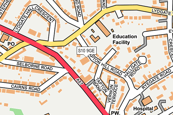
S10 9GE is located in the Crookes and Crosspool electoral ward, within the metropolitan district of Sheffield and the English Parliamentary constituency of Sheffield, Hallam. The Sub Integrated Care Board (ICB) Location is NHS South Yorkshire ICB - 03N and the police force is South Yorkshire. This postcode has been in use since July 2015.


GetTheData
Source: OS OpenMap – Local (Ordnance Survey)
Source: OS VectorMap District (Ordnance Survey)
Licence: Open Government Licence (requires attribution)
| Easting | 432286 |
| Northing | 387037 |
| Latitude | 53.379204 |
| Longitude | -1.516126 |
GetTheData
Source: Open Postcode Geo
Licence: Open Government Licence
| Country | England |
| Postcode District | S10 |
➜ See where S10 is on a map ➜ Where is Sheffield? | |
GetTheData
Source: Land Registry Price Paid Data
Licence: Open Government Licence
Elevation or altitude of S10 9GE as distance above sea level:
| Metres | Feet | |
|---|---|---|
| Elevation | 230m | 755ft |
Elevation is measured from the approximate centre of the postcode, to the nearest point on an OS contour line from OS Terrain 50, which has contour spacing of ten vertical metres.
➜ How high above sea level am I? Find the elevation of your current position using your device's GPS.
GetTheData
Source: Open Postcode Elevation
Licence: Open Government Licence
| Ward | Crookes And Crosspool |
| Constituency | Sheffield, Hallam |
GetTheData
Source: ONS Postcode Database
Licence: Open Government Licence
| Vernon Terrace (Manchester Road) | Crosspool | 139m |
| Vernon Terrace (Manchester Road) | Crosspool | 191m |
| Post Office (Sandygate Road) | Crosspool | 256m |
| Post Office (Sandygate Road) | Crosspool | 266m |
| Sandygate Road (Manchester Road) | Crosspool | 289m |
| Sheffield Station | 3.6km |
GetTheData
Source: NaPTAN
Licence: Open Government Licence
GetTheData
Source: ONS Postcode Database
Licence: Open Government Licence


➜ Get more ratings from the Food Standards Agency
GetTheData
Source: Food Standards Agency
Licence: FSA terms & conditions
| Last Collection | |||
|---|---|---|---|
| Location | Mon-Fri | Sat | Distance |
| Tapton Hill Road | 18:00 | 09:00 | 192m |
| Crosspool Post Office | 17:30 | 12:00 | 265m |
| 37 Cross Lane | 18:00 | 09:00 | 366m |
GetTheData
Source: Dracos
Licence: Creative Commons Attribution-ShareAlike
The below table lists the International Territorial Level (ITL) codes (formerly Nomenclature of Territorial Units for Statistics (NUTS) codes) and Local Administrative Units (LAU) codes for S10 9GE:
| ITL 1 Code | Name |
|---|---|
| TLE | Yorkshire and The Humber |
| ITL 2 Code | Name |
| TLE3 | South Yorkshire |
| ITL 3 Code | Name |
| TLE32 | Sheffield |
| LAU 1 Code | Name |
| E08000019 | Sheffield |
GetTheData
Source: ONS Postcode Directory
Licence: Open Government Licence
The below table lists the Census Output Area (OA), Lower Layer Super Output Area (LSOA), and Middle Layer Super Output Area (MSOA) for S10 9GE:
| Code | Name | |
|---|---|---|
| OA | E00040320 | |
| LSOA | E01007961 | Sheffield 033D |
| MSOA | E02001643 | Sheffield 033 |
GetTheData
Source: ONS Postcode Directory
Licence: Open Government Licence
| S10 5GF | Tapton Hill Road | 39m |
| S10 5DR | Manchester Road | 50m |
| S10 5GD | Tapton Hill Road | 66m |
| S10 5FR | Lydgate Lane | 90m |
| S10 5GG | Tapton Bank | 98m |
| S10 5GH | Tapton Bank | 99m |
| S10 5DQ | Manchester Road | 107m |
| S10 5DS | Manchester Road | 132m |
| S10 5GB | Tapton Hill Road | 141m |
| S10 5GJ | Vernon Terrace | 152m |
GetTheData
Source: Open Postcode Geo; Land Registry Price Paid Data
Licence: Open Government Licence