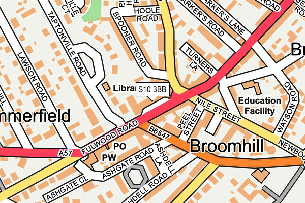
S10 3BB is located in the Broomhill and Sharrow Vale electoral ward, within the metropolitan district of Sheffield and the English Parliamentary constituency of Sheffield Central. The Sub Integrated Care Board (ICB) Location is NHS South Yorkshire ICB - 03N and the police force is South Yorkshire. This postcode has been in use since January 1980.


GetTheData
Source: OS OpenMap – Local (Ordnance Survey)
Source: OS VectorMap District (Ordnance Survey)
Licence: Open Government Licence (requires attribution)
| Easting | 433258 |
| Northing | 386856 |
| Latitude | 53.377535 |
| Longitude | -1.501533 |
GetTheData
Source: Open Postcode Geo
Licence: Open Government Licence
| Country | England |
| Postcode District | S10 |
➜ See where S10 is on a map ➜ Where is Sheffield? | |
GetTheData
Source: Land Registry Price Paid Data
Licence: Open Government Licence
Elevation or altitude of S10 3BB as distance above sea level:
| Metres | Feet | |
|---|---|---|
| Elevation | 170m | 558ft |
Elevation is measured from the approximate centre of the postcode, to the nearest point on an OS contour line from OS Terrain 50, which has contour spacing of ten vertical metres.
➜ How high above sea level am I? Find the elevation of your current position using your device's GPS.
GetTheData
Source: Open Postcode Elevation
Licence: Open Government Licence
| Ward | Broomhill And Sharrow Vale |
| Constituency | Sheffield Central |
GetTheData
Source: ONS Postcode Database
Licence: Open Government Licence
| Spooner Road Bh8 (Crookes Road) | Broomhill | 50m |
| Ashgate Road (Glossop Road) | Broomhill | 68m |
| Peel Street (Nile Street) | Broomhill | 106m |
| Turners Lane (Whitham Road) | Broomhill | 123m |
| Beech Hill Road (Whitham Road) | Broomhill | 135m |
| University Of Sheffield (Sheffield Supertram) (Hanover Street) | Western Bank | 1,215m |
| Netherthorpe Road (Sheffield Supertram) (Netherthorpe Road) | Netherthorpe | 1,498m |
| Infirmary Road (Sheffield Supertram) (Infirmary Road) | Upperthorpe | 1,955m |
| Sheffield Station | 2.6km |
GetTheData
Source: NaPTAN
Licence: Open Government Licence
| Median download speed | 22.6Mbps |
| Average download speed | 23.0Mbps |
| Maximum download speed | 40.00Mbps |
| Median upload speed | 1.2Mbps |
| Average upload speed | 1.2Mbps |
| Maximum upload speed | 2.00Mbps |
GetTheData
Source: Ofcom
Licence: Ofcom Terms of Use (requires attribution)
GetTheData
Source: ONS Postcode Database
Licence: Open Government Licence


➜ Get more ratings from the Food Standards Agency
GetTheData
Source: Food Standards Agency
Licence: FSA terms & conditions
| Last Collection | |||
|---|---|---|---|
| Location | Mon-Fri | Sat | Distance |
| 273 Fulwood Road | 17:30 | 10:30 | 126m |
| Broomhill Post Office | 17:30 | 10:30 | 128m |
| Westbourbne Road | 18:00 | 09:30 | 248m |
GetTheData
Source: Dracos
Licence: Creative Commons Attribution-ShareAlike
The below table lists the International Territorial Level (ITL) codes (formerly Nomenclature of Territorial Units for Statistics (NUTS) codes) and Local Administrative Units (LAU) codes for S10 3BB:
| ITL 1 Code | Name |
|---|---|
| TLE | Yorkshire and The Humber |
| ITL 2 Code | Name |
| TLE3 | South Yorkshire |
| ITL 3 Code | Name |
| TLE32 | Sheffield |
| LAU 1 Code | Name |
| E08000019 | Sheffield |
GetTheData
Source: ONS Postcode Directory
Licence: Open Government Licence
The below table lists the Census Output Area (OA), Lower Layer Super Output Area (LSOA), and Middle Layer Super Output Area (MSOA) for S10 3BB:
| Code | Name | |
|---|---|---|
| OA | E00039842 | |
| LSOA | E01007867 | Sheffield 030B |
| MSOA | E02001640 | Sheffield 030 |
GetTheData
Source: ONS Postcode Directory
Licence: Open Government Licence
| S10 3BA | Fulwood Road | 46m |
| S10 2QE | Glossop Road | 74m |
| S10 2PN | Nile Street | 85m |
| S10 5BB | Crookes Road | 87m |
| S10 2SS | Whitham Road | 94m |
| S10 5BA | Crookes Road | 104m |
| S10 3BD | Fulwood Road | 105m |
| S10 2QA | Glossop Road | 107m |
| S10 5BN | Spooner Road | 108m |
| S10 2SP | Whitham Road | 112m |
GetTheData
Source: Open Postcode Geo; Land Registry Price Paid Data
Licence: Open Government Licence