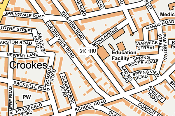
S10 1HU lies on Sandhurst Place in Sheffield. S10 1HU is located in the Crookes and Crosspool electoral ward, within the metropolitan district of Sheffield and the English Parliamentary constituency of Sheffield, Hallam. The Sub Integrated Care Board (ICB) Location is NHS South Yorkshire ICB - 03N and the police force is South Yorkshire. This postcode has been in use since January 1980.


GetTheData
Source: OS OpenMap – Local (Ordnance Survey)
Source: OS VectorMap District (Ordnance Survey)
Licence: Open Government Licence (requires attribution)
| Easting | 433145 |
| Northing | 387695 |
| Latitude | 53.385083 |
| Longitude | -1.503144 |
GetTheData
Source: Open Postcode Geo
Licence: Open Government Licence
| Street | Sandhurst Place |
| Town/City | Sheffield |
| Country | England |
| Postcode District | S10 |
➜ See where S10 is on a map ➜ Where is Sheffield? | |
GetTheData
Source: Land Registry Price Paid Data
Licence: Open Government Licence
Elevation or altitude of S10 1HU as distance above sea level:
| Metres | Feet | |
|---|---|---|
| Elevation | 190m | 623ft |
Elevation is measured from the approximate centre of the postcode, to the nearest point on an OS contour line from OS Terrain 50, which has contour spacing of ten vertical metres.
➜ How high above sea level am I? Find the elevation of your current position using your device's GPS.
GetTheData
Source: Open Postcode Elevation
Licence: Open Government Licence
| Ward | Crookes And Crosspool |
| Constituency | Sheffield, Hallam |
GetTheData
Source: ONS Postcode Database
Licence: Open Government Licence
| Toyne Street (Crookes) | Crookes | 328m |
| Sackville Road (Crookes) | Crookes | 328m |
| Duncan Road (Crookes) | Crookes | 343m |
| School Road (Crookes) | Crookes | 359m |
| Brick Street (Crookes) | Crookes | 364m |
| University Of Sheffield (Sheffield Supertram) (Hanover Street) | Western Bank | 1,360m |
| Netherthorpe Road (Sheffield Supertram) (Netherthorpe Road) | Netherthorpe | 1,372m |
| Langsett - Primrose View (Sheffield Supertram) (Langsett Road) | Langsett Road | 1,502m |
| Infirmary Road (Sheffield Supertram) (Infirmary Road) | Upperthorpe | 1,520m |
| Sheffield Station | 2.8km |
GetTheData
Source: NaPTAN
Licence: Open Government Licence
| Percentage of properties with Next Generation Access | 100.0% |
| Percentage of properties with Superfast Broadband | 100.0% |
| Percentage of properties with Ultrafast Broadband | 0.0% |
| Percentage of properties with Full Fibre Broadband | 0.0% |
Superfast Broadband is between 30Mbps and 300Mbps
Ultrafast Broadband is > 300Mbps
| Percentage of properties unable to receive 2Mbps | 0.0% |
| Percentage of properties unable to receive 5Mbps | 0.0% |
| Percentage of properties unable to receive 10Mbps | 0.0% |
| Percentage of properties unable to receive 30Mbps | 0.0% |
GetTheData
Source: Ofcom
Licence: Ofcom Terms of Use (requires attribution)
GetTheData
Source: ONS Postcode Database
Licence: Open Government Licence


➜ Get more ratings from the Food Standards Agency
GetTheData
Source: Food Standards Agency
Licence: FSA terms & conditions
| Last Collection | |||
|---|---|---|---|
| Location | Mon-Fri | Sat | Distance |
| 225 School Road | 17:00 | 11:30 | 166m |
| Crookes Post Office | 17:30 | 11:30 | 346m |
| Stannington View Road | 17:45 | 11:30 | 348m |
GetTheData
Source: Dracos
Licence: Creative Commons Attribution-ShareAlike
The below table lists the International Territorial Level (ITL) codes (formerly Nomenclature of Territorial Units for Statistics (NUTS) codes) and Local Administrative Units (LAU) codes for S10 1HU:
| ITL 1 Code | Name |
|---|---|
| TLE | Yorkshire and The Humber |
| ITL 2 Code | Name |
| TLE3 | South Yorkshire |
| ITL 3 Code | Name |
| TLE32 | Sheffield |
| LAU 1 Code | Name |
| E08000019 | Sheffield |
GetTheData
Source: ONS Postcode Directory
Licence: Open Government Licence
The below table lists the Census Output Area (OA), Lower Layer Super Output Area (LSOA), and Middle Layer Super Output Area (MSOA) for S10 1HU:
| Code | Name | |
|---|---|---|
| OA | E00040862 | |
| LSOA | E01008069 | Sheffield 028C |
| MSOA | E02001638 | Sheffield 028 |
GetTheData
Source: ONS Postcode Directory
Licence: Open Government Licence
| S10 1LB | Western Road | 57m |
| S10 1HP | Cobden View Road | 82m |
| S10 1HQ | Cobden View Road | 87m |
| S10 1HS | Cobden View Road | 89m |
| S10 1LD | Western Road | 90m |
| S10 1HN | Cobden Terrace | 93m |
| S10 1LA | Western Road | 105m |
| S10 1HR | Cobden View Road | 116m |
| S10 1NE | Mona Avenue | 119m |
| S10 1LR | Ramsey Road | 125m |
GetTheData
Source: Open Postcode Geo; Land Registry Price Paid Data
Licence: Open Government Licence