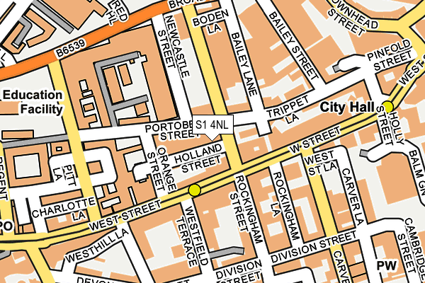
S1 4NL is located in the City electoral ward, within the metropolitan district of Sheffield and the English Parliamentary constituency of Sheffield Central. The Sub Integrated Care Board (ICB) Location is NHS South Yorkshire ICB - 03N and the police force is South Yorkshire. This postcode has been in use since September 2009.


GetTheData
Source: OS OpenMap – Local (Ordnance Survey)
Source: OS VectorMap District (Ordnance Survey)
Licence: Open Government Licence (requires attribution)
| Easting | 434896 |
| Northing | 387281 |
| Latitude | 53.381250 |
| Longitude | -1.476865 |
GetTheData
Source: Open Postcode Geo
Licence: Open Government Licence
| Country | England |
| Postcode District | S1 |
➜ See where S1 is on a map ➜ Where is Sheffield? | |
GetTheData
Source: Land Registry Price Paid Data
Licence: Open Government Licence
Elevation or altitude of S1 4NL as distance above sea level:
| Metres | Feet | |
|---|---|---|
| Elevation | 90m | 295ft |
Elevation is measured from the approximate centre of the postcode, to the nearest point on an OS contour line from OS Terrain 50, which has contour spacing of ten vertical metres.
➜ How high above sea level am I? Find the elevation of your current position using your device's GPS.
GetTheData
Source: Open Postcode Elevation
Licence: Open Government Licence
| Ward | City |
| Constituency | Sheffield Central |
GetTheData
Source: ONS Postcode Database
Licence: Open Government Licence
| Portobello Road (Rockingham Street) | Sheffield Centre | 89m |
| Rockingham Street (West Street) | Sheffield Centre | 96m |
| Portobello Lane (Mappin Street) | Sheffield Centre | 153m |
| Mappin Street (West Street) | Sheffield Centre | 188m |
| City Hall (West Street) | Sheffield Centre | 190m |
| West Street (Sheffield Supertram) (West Street) | Sheffield Centre | 86m |
| City Hall (Sheffield Supertram) (West Street) | Sheffield Centre | 273m |
| University Of Sheffield (Sheffield Supertram) (Hanover Street) | Western Bank | 482m |
| Netherthorpe Road (Sheffield Supertram) (Netherthorpe Road) | Netherthorpe | 541m |
| Cathedral (Sheffield Supertram) (Church Street) | Sheffield Centre | 541m |
| Sheffield Station | 1km |
| Darnall Station | 4.3km |
| Meadowhall Station | 5.9km |
GetTheData
Source: NaPTAN
Licence: Open Government Licence
GetTheData
Source: ONS Postcode Database
Licence: Open Government Licence


➜ Get more ratings from the Food Standards Agency
GetTheData
Source: Food Standards Agency
Licence: FSA terms & conditions
| Last Collection | |||
|---|---|---|---|
| Location | Mon-Fri | Sat | Distance |
| Rockingham Street | 18:30 | 10:00 | 85m |
| Broad Lane | 18:30 | 11:00 | 215m |
| West Street Post Office | 18:30 | 12:40 | 252m |
GetTheData
Source: Dracos
Licence: Creative Commons Attribution-ShareAlike
The below table lists the International Territorial Level (ITL) codes (formerly Nomenclature of Territorial Units for Statistics (NUTS) codes) and Local Administrative Units (LAU) codes for S1 4NL:
| ITL 1 Code | Name |
|---|---|
| TLE | Yorkshire and The Humber |
| ITL 2 Code | Name |
| TLE3 | South Yorkshire |
| ITL 3 Code | Name |
| TLE32 | Sheffield |
| LAU 1 Code | Name |
| E08000019 | Sheffield |
GetTheData
Source: ONS Postcode Directory
Licence: Open Government Licence
The below table lists the Census Output Area (OA), Lower Layer Super Output Area (LSOA), and Middle Layer Super Output Area (MSOA) for S1 4NL:
| Code | Name | |
|---|---|---|
| OA | E00172499 | |
| LSOA | E01033266 | Sheffield 074D |
| MSOA | E02006844 | Sheffield 074 |
GetTheData
Source: ONS Postcode Directory
Licence: Open Government Licence
| S1 4ND | Portobello Street | 79m |
| S1 4ET | West Street | 103m |
| S1 4GD | Westfield Terrace | 107m |
| S1 4GG | Westfield Terrace | 115m |
| S1 4EN | Penton Street | 119m |
| S1 4GH | Westfield Terrace | 126m |
| S1 4FZ | Rockingham Lane | 126m |
| S1 4DZ | West Street | 137m |
| S1 4EY | Rockingham Street | 147m |
| S1 4EB | Rockingham Street | 149m |
GetTheData
Source: Open Postcode Geo; Land Registry Price Paid Data
Licence: Open Government Licence