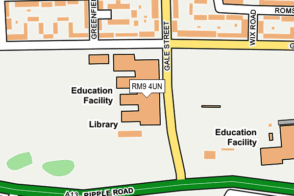
RM9 4UN is located in the Eastbury electoral ward, within the London borough of Barking and Dagenham and the English Parliamentary constituency of Barking. The Sub Integrated Care Board (ICB) Location is NHS North East London ICB - A3A8R and the police force is Metropolitan Police. This postcode has been in use since February 2004.


GetTheData
Source: OS OpenMap – Local (Ordnance Survey)
Source: OS VectorMap District (Ordnance Survey)
Licence: Open Government Licence (requires attribution)
| Easting | 547589 |
| Northing | 183746 |
| Latitude | 51.533334 |
| Longitude | 0.126459 |
GetTheData
Source: Open Postcode Geo
Licence: Open Government Licence
| Country | England |
| Postcode District | RM9 |
➜ See where RM9 is on a map ➜ Where is Barking? | |
GetTheData
Source: Land Registry Price Paid Data
Licence: Open Government Licence
Elevation or altitude of RM9 4UN as distance above sea level:
| Metres | Feet | |
|---|---|---|
| Elevation | 0m | 0ft |
Elevation is measured from the approximate centre of the postcode, to the nearest point on an OS contour line from OS Terrain 50, which has contour spacing of ten vertical metres.
➜ How high above sea level am I? Find the elevation of your current position using your device's GPS.
GetTheData
Source: Open Postcode Elevation
Licence: Open Government Licence
| Ward | Eastbury |
| Constituency | Barking |
GetTheData
Source: ONS Postcode Database
Licence: Open Government Licence
| Gale St Goresbrook Leisure C | Dagenham | 206m |
| Castle Green Recreation Ground (Ripple Road) | Dagenham | 249m |
| Gale St Goresbrook Leisure C | Dagenham | 272m |
| Castle Green Rippleside Commercial Est | Dagenham | 353m |
| Renwick Road (Ripple Road) | Creekmouth | 544m |
| Becontree Underground Station | Dagenham | 779m |
| Dagenham Heathway Underground Station | Dagenham | 1,729m |
| Dagenham Dock Station | 1.6km |
| Barking Station | 3.2km |
| Goodmayes Station | 3.7km |
GetTheData
Source: NaPTAN
Licence: Open Government Licence
GetTheData
Source: ONS Postcode Database
Licence: Open Government Licence


➜ Get more ratings from the Food Standards Agency
GetTheData
Source: Food Standards Agency
Licence: FSA terms & conditions
| Last Collection | |||
|---|---|---|---|
| Location | Mon-Fri | Sat | Distance |
| Woodward Road Post Office | 17:30 | 12:30 | 617m |
| Valence Wood Road | 17:00 | 12:00 | 1,020m |
| River Road | 18:30 | 12:30 | 1,203m |
GetTheData
Source: Dracos
Licence: Creative Commons Attribution-ShareAlike
The below table lists the International Territorial Level (ITL) codes (formerly Nomenclature of Territorial Units for Statistics (NUTS) codes) and Local Administrative Units (LAU) codes for RM9 4UN:
| ITL 1 Code | Name |
|---|---|
| TLI | London |
| ITL 2 Code | Name |
| TLI5 | Outer London - East and North East |
| ITL 3 Code | Name |
| TLI52 | Barking & Dagenham and Havering |
| LAU 1 Code | Name |
| E09000002 | Barking and Dagenham |
GetTheData
Source: ONS Postcode Directory
Licence: Open Government Licence
The below table lists the Census Output Area (OA), Lower Layer Super Output Area (LSOA), and Middle Layer Super Output Area (MSOA) for RM9 4UN:
| Code | Name | |
|---|---|---|
| OA | E00000458 | |
| LSOA | E01000096 | Barking and Dagenham 022D |
| MSOA | E02000023 | Barking and Dagenham 022 |
GetTheData
Source: ONS Postcode Directory
Licence: Open Government Licence
| RM9 4UU | Goresbrook Road | 135m |
| RM9 4RU | Greenfield Gardens | 168m |
| RM9 4TX | Gale Street | 176m |
| RM9 6XX | Goresbrook Road | 182m |
| RM9 4UL | Gale Street | 189m |
| RM9 4RT | Greenfield Road | 214m |
| RM9 4UX | Goresbrook Road | 240m |
| RM9 6BL | Romsey Road | 244m |
| RM9 4RX | Langley Crescent | 257m |
| RM9 6TA | Langley Crescent | 258m |
GetTheData
Source: Open Postcode Geo; Land Registry Price Paid Data
Licence: Open Government Licence