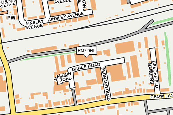
RM7 0HL lies on Danes Road in Romford. RM7 0HL is located in the Rush Green & Crowlands electoral ward, within the London borough of Havering and the English Parliamentary constituency of Romford. The Sub Integrated Care Board (ICB) Location is NHS North East London ICB - A3A8R and the police force is Metropolitan Police. This postcode has been in use since January 1980.


GetTheData
Source: OS OpenMap – Local (Ordnance Survey)
Source: OS VectorMap District (Ordnance Survey)
Licence: Open Government Licence (requires attribution)
| Easting | 550259 |
| Northing | 187893 |
| Latitude | 51.569893 |
| Longitude | 0.166721 |
GetTheData
Source: Open Postcode Geo
Licence: Open Government Licence
| Street | Danes Road |
| Town/City | Romford |
| Country | England |
| Postcode District | RM7 |
➜ See where RM7 is on a map ➜ Where is Romford? | |
GetTheData
Source: Land Registry Price Paid Data
Licence: Open Government Licence
Elevation or altitude of RM7 0HL as distance above sea level:
| Metres | Feet | |
|---|---|---|
| Elevation | 20m | 66ft |
Elevation is measured from the approximate centre of the postcode, to the nearest point on an OS contour line from OS Terrain 50, which has contour spacing of ten vertical metres.
➜ How high above sea level am I? Find the elevation of your current position using your device's GPS.
GetTheData
Source: Open Postcode Elevation
Licence: Open Government Licence
| Ward | Rush Green & Crowlands |
| Constituency | Romford |
GetTheData
Source: ONS Postcode Database
Licence: Open Government Licence
| Bernard Road (Crow Lane) | Rush Green | 134m |
| Crow Lane | Rush Green | 216m |
| Jutsums Lane Crow Lane (Crow Lane) | Rush Green | 266m |
| Romford Cemetery (Crow Lane) | Rush Green | 327m |
| Jutsums Lane Crow Lane | Rush Green | 407m |
| Romford Station | 1.3km |
| Chadwell Heath Station | 2.6km |
| Gidea Park Station | 3km |
GetTheData
Source: NaPTAN
Licence: Open Government Licence
Estimated total energy consumption in RM7 0HL by fuel type, 2015.
| Consumption (kWh) | 139,740 |
|---|---|
| Meter count | 7 |
| Mean (kWh/meter) | 19,963 |
| Median (kWh/meter) | 15,151 |
GetTheData
Source: Postcode level gas estimates: 2015 (experimental)
Source: Postcode level electricity estimates: 2015 (experimental)
Licence: Open Government Licence
GetTheData
Source: ONS Postcode Database
Licence: Open Government Licence


➜ Get more ratings from the Food Standards Agency
GetTheData
Source: Food Standards Agency
Licence: FSA terms & conditions
| Last Collection | |||
|---|---|---|---|
| Location | Mon-Fri | Sat | Distance |
| Romford Mail Centre | 19:30 | 13:30 | 267m |
| Romford Mail Centre | 19:30 | 13:30 | 282m |
| Baron Road | 17:30 | 12:15 | 646m |
GetTheData
Source: Dracos
Licence: Creative Commons Attribution-ShareAlike
The below table lists the International Territorial Level (ITL) codes (formerly Nomenclature of Territorial Units for Statistics (NUTS) codes) and Local Administrative Units (LAU) codes for RM7 0HL:
| ITL 1 Code | Name |
|---|---|
| TLI | London |
| ITL 2 Code | Name |
| TLI5 | Outer London - East and North East |
| ITL 3 Code | Name |
| TLI52 | Barking & Dagenham and Havering |
| LAU 1 Code | Name |
| E09000016 | Havering |
GetTheData
Source: ONS Postcode Directory
Licence: Open Government Licence
The below table lists the Census Output Area (OA), Lower Layer Super Output Area (LSOA), and Middle Layer Super Output Area (MSOA) for RM7 0HL:
| Code | Name | |
|---|---|---|
| OA | E00011243 | |
| LSOA | E01002248 | Havering 017C |
| MSOA | E02000480 | Havering 017 |
GetTheData
Source: ONS Postcode Directory
Licence: Open Government Licence
| RM7 0HX | Bernard Road | 77m |
| RM7 0EL | Crow Lane | 90m |
| RM7 0EJ | Beechfield Gardens | 108m |
| RM7 0EN | Lambert Court | 109m |
| RM7 0ED | Crow Lane | 187m |
| RM7 0EP | Crow Lane | 233m |
| RM7 9HU | Ainsley Avenue | 244m |
| RM7 9DR | Sheringham Avenue | 246m |
| RM7 9ED | Lessington Avenue | 278m |
| RM7 9DP | Sheringham Avenue | 316m |
GetTheData
Source: Open Postcode Geo; Land Registry Price Paid Data
Licence: Open Government Licence