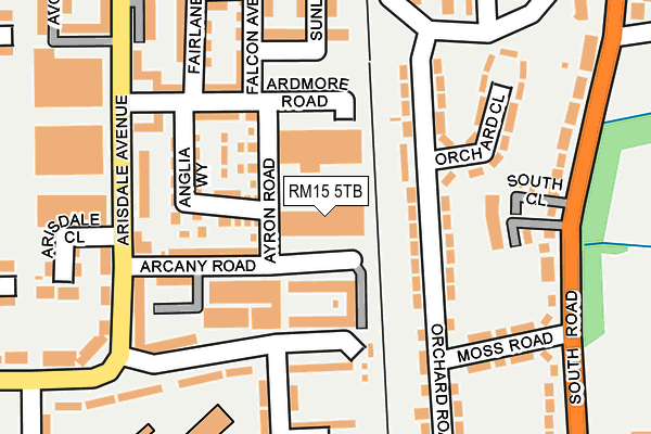
RM15 5TB lies on Arcany Road in South Ockendon. RM15 5TB is located in the Ockendon electoral ward, within the unitary authority of Thurrock and the English Parliamentary constituency of Thurrock. The Sub Integrated Care Board (ICB) Location is NHS Mid and South Essex ICB - 07G and the police force is Essex. This postcode has been in use since January 1980.


GetTheData
Source: OS OpenMap – Local (Ordnance Survey)
Source: OS VectorMap District (Ordnance Survey)
Licence: Open Government Licence (requires attribution)
| Easting | 558973 |
| Northing | 182056 |
| Latitude | 51.515064 |
| Longitude | 0.289717 |
GetTheData
Source: Open Postcode Geo
Licence: Open Government Licence
| Street | Arcany Road |
| Town/City | South Ockendon |
| Country | England |
| Postcode District | RM15 |
➜ See where RM15 is on a map ➜ Where is South Ockendon? | |
GetTheData
Source: Land Registry Price Paid Data
Licence: Open Government Licence
Elevation or altitude of RM15 5TB as distance above sea level:
| Metres | Feet | |
|---|---|---|
| Elevation | 20m | 66ft |
Elevation is measured from the approximate centre of the postcode, to the nearest point on an OS contour line from OS Terrain 50, which has contour spacing of ten vertical metres.
➜ How high above sea level am I? Find the elevation of your current position using your device's GPS.
GetTheData
Source: Open Postcode Elevation
Licence: Open Government Licence
| Ward | Ockendon |
| Constituency | Thurrock |
GetTheData
Source: ONS Postcode Database
Licence: Open Government Licence
| Arcany Road (Arisdale Avenue) | South Ockendon | 183m |
| Arcany Road (Arisdale Avenue) | South Ockendon | 188m |
| Moss Road (South Road) | South Ockendon | 260m |
| Tamarisk Road | South Ockendon | 274m |
| Mayflower Close (Tamarisk Road) | South Ockendon | 350m |
| Ockendon Station | 0.8km |
| Chafford Hundred Station | 3.3km |
| Grays Station | 4.9km |
GetTheData
Source: NaPTAN
Licence: Open Government Licence
GetTheData
Source: ONS Postcode Database
Licence: Open Government Licence


➜ Get more ratings from the Food Standards Agency
GetTheData
Source: Food Standards Agency
Licence: FSA terms & conditions
| Last Collection | |||
|---|---|---|---|
| Location | Mon-Fri | Sat | Distance |
| Arisdale Avenue | 17:15 | 12:15 | 318m |
| South Parade | 16:45 | 12:15 | 440m |
| Barle Gardens | 17:30 | 11:30 | 794m |
GetTheData
Source: Dracos
Licence: Creative Commons Attribution-ShareAlike
The below table lists the International Territorial Level (ITL) codes (formerly Nomenclature of Territorial Units for Statistics (NUTS) codes) and Local Administrative Units (LAU) codes for RM15 5TB:
| ITL 1 Code | Name |
|---|---|
| TLH | East |
| ITL 2 Code | Name |
| TLH3 | Essex |
| ITL 3 Code | Name |
| TLH32 | Thurrock |
| LAU 1 Code | Name |
| E06000034 | Thurrock |
GetTheData
Source: ONS Postcode Directory
Licence: Open Government Licence
The below table lists the Census Output Area (OA), Lower Layer Super Output Area (LSOA), and Middle Layer Super Output Area (MSOA) for RM15 5TB:
| Code | Name | |
|---|---|---|
| OA | E00080760 | |
| LSOA | E01015973 | Thurrock 006D |
| MSOA | E02003301 | Thurrock 006 |
GetTheData
Source: ONS Postcode Directory
Licence: Open Government Licence
| RM15 5FF | Arcany Road | 59m |
| RM15 5FJ | Ayron Road | 86m |
| RM15 6HD | Orchard Road | 95m |
| RM15 5TH | Ardmore Road | 117m |
| RM15 5FN | Anglia Way | 120m |
| RM15 5FP | Arcany Road | 130m |
| RM15 6HB | Orchard Road | 138m |
| RM15 5FL | Anglia Way | 139m |
| RM15 5FG | Arcany Road | 141m |
| RM15 6BF | South Close | 163m |
GetTheData
Source: Open Postcode Geo; Land Registry Price Paid Data
Licence: Open Government Licence