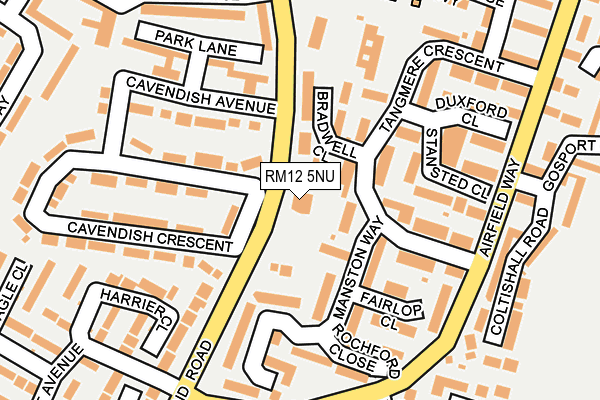
RM12 5NU is located in the Elm Park electoral ward, within the London borough of Havering and the English Parliamentary constituency of Dagenham and Rainham. The Sub Integrated Care Board (ICB) Location is NHS North East London ICB - A3A8R and the police force is Metropolitan Police. This postcode has been in use since January 1980.


GetTheData
Source: OS OpenMap – Local (Ordnance Survey)
Source: OS VectorMap District (Ordnance Survey)
Licence: Open Government Licence (requires attribution)
| Easting | 552864 |
| Northing | 184712 |
| Latitude | 51.540613 |
| Longitude | 0.202899 |
GetTheData
Source: Open Postcode Geo
Licence: Open Government Licence
| Country | England |
| Postcode District | RM12 |
➜ See where RM12 is on a map ➜ Where is London? | |
GetTheData
Source: Land Registry Price Paid Data
Licence: Open Government Licence
Elevation or altitude of RM12 5NU as distance above sea level:
| Metres | Feet | |
|---|---|---|
| Elevation | 10m | 33ft |
Elevation is measured from the approximate centre of the postcode, to the nearest point on an OS contour line from OS Terrain 50, which has contour spacing of ten vertical metres.
➜ How high above sea level am I? Find the elevation of your current position using your device's GPS.
GetTheData
Source: Open Postcode Elevation
Licence: Open Government Licence
| Ward | Elm Park |
| Constituency | Dagenham And Rainham |
GetTheData
Source: ONS Postcode Database
Licence: Open Government Licence
| Heron Flight Avenue (South End Road) | Elm Park | 27m |
| Heron Flight Avenue (South End Road) | Elm Park | 66m |
| Gosport Drive | Elm Park | 196m |
| Dowding Way (Airfield Way) | Elm Park | 209m |
| Dowding Way (Airfield Way) | Elm Park | 221m |
| Elm Park Underground Station | Elm Park | 1,061m |
| Rainham (London) Station | 2.8km |
| Emerson Park Station | 3.3km |
| Upminster Station | 3.9km |
GetTheData
Source: NaPTAN
Licence: Open Government Licence
GetTheData
Source: ONS Postcode Database
Licence: Open Government Licence


➜ Get more ratings from the Food Standards Agency
GetTheData
Source: Food Standards Agency
Licence: FSA terms & conditions
| Last Collection | |||
|---|---|---|---|
| Location | Mon-Fri | Sat | Distance |
| Elm Park Avenue | 17:30 | 11:30 | 1,002m |
| Swanbourne Drive | 17:15 | 12:30 | 1,012m |
| Elm Park Post Office | 18:30 | 12:00 | 1,170m |
GetTheData
Source: Dracos
Licence: Creative Commons Attribution-ShareAlike
The below table lists the International Territorial Level (ITL) codes (formerly Nomenclature of Territorial Units for Statistics (NUTS) codes) and Local Administrative Units (LAU) codes for RM12 5NU:
| ITL 1 Code | Name |
|---|---|
| TLI | London |
| ITL 2 Code | Name |
| TLI5 | Outer London - East and North East |
| ITL 3 Code | Name |
| TLI52 | Barking & Dagenham and Havering |
| LAU 1 Code | Name |
| E09000016 | Havering |
GetTheData
Source: ONS Postcode Directory
Licence: Open Government Licence
The below table lists the Census Output Area (OA), Lower Layer Super Output Area (LSOA), and Middle Layer Super Output Area (MSOA) for RM12 5NU:
| Code | Name | |
|---|---|---|
| OA | E00011286 | |
| LSOA | E01002263 | Havering 026D |
| MSOA | E02000489 | Havering 026 |
GetTheData
Source: ONS Postcode Directory
Licence: Open Government Licence
| RM12 5PJ | Manston Way | 70m |
| RM12 5PR | Bradwell Close | 85m |
| RM12 5PP | Tangmere Crescent | 89m |
| RM12 5PB | Manston Way | 118m |
| RM12 5PU | Debden Walk | 126m |
| RM12 5PL | Tangmere Crescent | 135m |
| RM12 5PH | Fairlop Close | 138m |
| RM12 5NS | Cavendish Avenue | 143m |
| RM12 5PT | Stansted Close | 152m |
| RM12 5LR | Harrier Close | 160m |
GetTheData
Source: Open Postcode Geo; Land Registry Price Paid Data
Licence: Open Government Licence