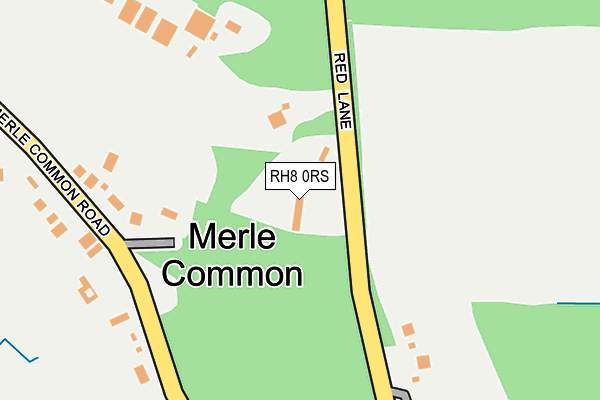
RH8 0RS lies on Red Lane in Oxted. RH8 0RS is located in the Oxted South electoral ward, within the local authority district of Tandridge and the English Parliamentary constituency of East Surrey. The Sub Integrated Care Board (ICB) Location is NHS Surrey Heartlands ICB - 92A and the police force is Surrey. This postcode has been in use since January 1980.


GetTheData
Source: OS OpenMap – Local (Ordnance Survey)
Source: OS VectorMap District (Ordnance Survey)
Licence: Open Government Licence (requires attribution)
| Easting | 540749 |
| Northing | 149338 |
| Latitude | 51.225887 |
| Longitude | 0.014291 |
GetTheData
Source: Open Postcode Geo
Licence: Open Government Licence
| Street | Red Lane |
| Town/City | Oxted |
| Country | England |
| Postcode District | RH8 |
➜ See where RH8 is on a map ➜ Where is Merle Common? | |
GetTheData
Source: Land Registry Price Paid Data
Licence: Open Government Licence
Elevation or altitude of RH8 0RS as distance above sea level:
| Metres | Feet | |
|---|---|---|
| Elevation | 90m | 295ft |
Elevation is measured from the approximate centre of the postcode, to the nearest point on an OS contour line from OS Terrain 50, which has contour spacing of ten vertical metres.
➜ How high above sea level am I? Find the elevation of your current position using your device's GPS.
GetTheData
Source: Open Postcode Elevation
Licence: Open Government Licence
| Ward | Oxted South |
| Constituency | East Surrey |
GetTheData
Source: ONS Postcode Database
Licence: Open Government Licence
| Merle Common Road | Merle Common | 176m |
| Merle Common Road | Merle Common | 190m |
| Red Lane | Merle Common | 523m |
| Red Lane | Merle Common | 527m |
| Holland Road | Holland | 710m |
| Hurst Green Station | 2.2km |
| Edenbridge Station | 3.8km |
| Oxted Station | 3.8km |
GetTheData
Source: NaPTAN
Licence: Open Government Licence
| Percentage of properties with Next Generation Access | 100.0% |
| Percentage of properties with Superfast Broadband | 0.0% |
| Percentage of properties with Ultrafast Broadband | 0.0% |
| Percentage of properties with Full Fibre Broadband | 0.0% |
Superfast Broadband is between 30Mbps and 300Mbps
Ultrafast Broadband is > 300Mbps
| Median download speed | 10.4Mbps |
| Average download speed | 10.6Mbps |
| Maximum download speed | 14.23Mbps |
| Median upload speed | 0.6Mbps |
| Average upload speed | 0.6Mbps |
| Maximum upload speed | 0.84Mbps |
| Percentage of properties unable to receive 2Mbps | 0.0% |
| Percentage of properties unable to receive 5Mbps | 0.0% |
| Percentage of properties unable to receive 10Mbps | 0.0% |
| Percentage of properties unable to receive 30Mbps | 100.0% |
GetTheData
Source: Ofcom
Licence: Ofcom Terms of Use (requires attribution)
GetTheData
Source: ONS Postcode Database
Licence: Open Government Licence


➜ Get more ratings from the Food Standards Agency
GetTheData
Source: Food Standards Agency
Licence: FSA terms & conditions
| Last Collection | |||
|---|---|---|---|
| Location | Mon-Fri | Sat | Distance |
| Merle Common | 17:00 | 08:00 | 196m |
| Hurstlands | 17:15 | 12:00 | 1,927m |
| Little Browns | 16:15 | 09:00 | 2,480m |
GetTheData
Source: Dracos
Licence: Creative Commons Attribution-ShareAlike
The below table lists the International Territorial Level (ITL) codes (formerly Nomenclature of Territorial Units for Statistics (NUTS) codes) and Local Administrative Units (LAU) codes for RH8 0RS:
| ITL 1 Code | Name |
|---|---|
| TLJ | South East (England) |
| ITL 2 Code | Name |
| TLJ2 | Surrey, East and West Sussex |
| ITL 3 Code | Name |
| TLJ26 | East Surrey |
| LAU 1 Code | Name |
| E07000215 | Tandridge |
GetTheData
Source: ONS Postcode Directory
Licence: Open Government Licence
The below table lists the Census Output Area (OA), Lower Layer Super Output Area (LSOA), and Middle Layer Super Output Area (MSOA) for RH8 0RS:
| Code | Name | |
|---|---|---|
| OA | E00157252 | |
| LSOA | E01030843 | Tandridge 007D |
| MSOA | E02006434 | Tandridge 007 |
GetTheData
Source: ONS Postcode Directory
Licence: Open Government Licence
| RH8 0RP | Merle Common Road | 212m |
| RH8 9PN | Merle Common Road | 728m |
| RH8 0RT | Red Lane | 780m |
| RH8 0RR | Caterfield Lane | 820m |
| RH8 0RH | Grants Lane | 834m |
| RH8 9BQ | Holland Road | 918m |
| RH8 9PL | Popes Lane | 921m |
| RH8 9BG | Meadowlands | 996m |
| TN8 6QG | Dwelly Lane | 1105m |
| RH8 9DA | Warren Lane | 1112m |
GetTheData
Source: Open Postcode Geo; Land Registry Price Paid Data
Licence: Open Government Licence