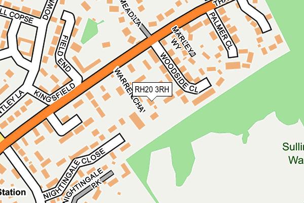
RH20 3RH lies on Warren Chase in Storrington, Pulborough. RH20 3RH is located in the Storrington & Washington electoral ward, within the local authority district of Horsham and the English Parliamentary constituency of Arundel and South Downs. The Sub Integrated Care Board (ICB) Location is NHS Sussex ICB - 70F and the police force is Sussex. This postcode has been in use since June 2002.


GetTheData
Source: OS OpenMap – Local (Ordnance Survey)
Source: OS VectorMap District (Ordnance Survey)
Licence: Open Government Licence (requires attribution)
| Easting | 509392 |
| Northing | 114597 |
| Latitude | 50.920467 |
| Longitude | -0.445047 |
GetTheData
Source: Open Postcode Geo
Licence: Open Government Licence
| Street | Warren Chase |
| Locality | Storrington |
| Town/City | Pulborough |
| Country | England |
| Postcode District | RH20 |
➜ See where RH20 is on a map ➜ Where is Storrington? | |
GetTheData
Source: Land Registry Price Paid Data
Licence: Open Government Licence
Elevation or altitude of RH20 3RH as distance above sea level:
| Metres | Feet | |
|---|---|---|
| Elevation | 60m | 197ft |
Elevation is measured from the approximate centre of the postcode, to the nearest point on an OS contour line from OS Terrain 50, which has contour spacing of ten vertical metres.
➜ How high above sea level am I? Find the elevation of your current position using your device's GPS.
GetTheData
Source: Open Postcode Elevation
Licence: Open Government Licence
| Ward | Storrington & Washington |
| Constituency | Arundel And South Downs |
GetTheData
Source: ONS Postcode Database
Licence: Open Government Licence
PINEWOOD HOUSE, WARREN CHASE, STORRINGTON, PULBOROUGH, RH20 3RH 2020 21 FEB £930,000 |
SPINNEY, WARREN CHASE, STORRINGTON, PULBOROUGH, RH20 3RH 2015 26 FEB £800,000 |
SILWOOD, WARREN CHASE, STORRINGTON, PULBOROUGH, RH20 3RH 2005 16 NOV £625,000 |
SPINNEY, WARREN CHASE, STORRINGTON, PULBOROUGH, RH20 3RH 2005 14 APR £620,000 |
PINEWOOD HOUSE, WARREN CHASE, STORRINGTON, PULBOROUGH, RH20 3RH 2004 11 MAY £655,000 |
SILWOOD, WARREN CHASE, STORRINGTON, PULBOROUGH, RH20 3RH 2002 5 NOV £559,950 |
SPINNEY, WARREN CHASE, STORRINGTON, PULBOROUGH, RH20 3RH 2001 24 OCT £500,000 |
GetTheData
Source: HM Land Registry Price Paid Data
Licence: Contains HM Land Registry data © Crown copyright and database right 2025. This data is licensed under the Open Government Licence v3.0.
| Mead Lane (Thakeham Road) | Storrington | 138m |
| Mead Lane (Thakeham Road) | Storrington | 150m |
| Nightingale Lane (Thakeham Road) | Storrington | 262m |
| Nightingale Lane (Thakeham Road) | Storrington | 269m |
| Sullington Copse (Thakeham Road) | Storrington | 299m |
GetTheData
Source: NaPTAN
Licence: Open Government Licence
| Percentage of properties with Next Generation Access | 100.0% |
| Percentage of properties with Superfast Broadband | 100.0% |
| Percentage of properties with Ultrafast Broadband | 0.0% |
| Percentage of properties with Full Fibre Broadband | 0.0% |
Superfast Broadband is between 30Mbps and 300Mbps
Ultrafast Broadband is > 300Mbps
| Percentage of properties unable to receive 2Mbps | 0.0% |
| Percentage of properties unable to receive 5Mbps | 0.0% |
| Percentage of properties unable to receive 10Mbps | 0.0% |
| Percentage of properties unable to receive 30Mbps | 0.0% |
GetTheData
Source: Ofcom
Licence: Ofcom Terms of Use (requires attribution)
GetTheData
Source: ONS Postcode Database
Licence: Open Government Licence


➜ Get more ratings from the Food Standards Agency
GetTheData
Source: Food Standards Agency
Licence: FSA terms & conditions
| Last Collection | |||
|---|---|---|---|
| Location | Mon-Fri | Sat | Distance |
| Storrington P O | 17:30 | 11:45 | 439m |
| Nightingale Lane | 17:00 | 10:15 | 448m |
| Sussex Down Raf Home | 17:00 | 10:15 | 500m |
GetTheData
Source: Dracos
Licence: Creative Commons Attribution-ShareAlike
The below table lists the International Territorial Level (ITL) codes (formerly Nomenclature of Territorial Units for Statistics (NUTS) codes) and Local Administrative Units (LAU) codes for RH20 3RH:
| ITL 1 Code | Name |
|---|---|
| TLJ | South East (England) |
| ITL 2 Code | Name |
| TLJ2 | Surrey, East and West Sussex |
| ITL 3 Code | Name |
| TLJ28 | West Sussex (North East) |
| LAU 1 Code | Name |
| E07000227 | Horsham |
GetTheData
Source: ONS Postcode Directory
Licence: Open Government Licence
The below table lists the Census Output Area (OA), Lower Layer Super Output Area (LSOA), and Middle Layer Super Output Area (MSOA) for RH20 3RH:
| Code | Name | |
|---|---|---|
| OA | E00161309 | |
| LSOA | E01031631 | Horsham 013C |
| MSOA | E02006600 | Horsham 013 |
GetTheData
Source: ONS Postcode Directory
Licence: Open Government Licence
| RH20 3NG | Thakeham Road | 70m |
| RH20 3NR | Woodside Close | 88m |
| RH20 3NH | Marley Way | 120m |
| RH20 3ND | Kingsfield | 148m |
| RH20 3NF | Timberlands | 167m |
| RH20 4LY | Nightingale Park | 180m |
| RH20 4NX | Nightingale Close | 183m |
| RH20 3PH | Field End | 189m |
| RH20 3PP | Thakeham Road | 195m |
| RH20 3PJ | Mead Lane | 197m |
GetTheData
Source: Open Postcode Geo; Land Registry Price Paid Data
Licence: Open Government Licence