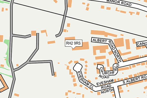
RH2 9RS is located in the Reigate electoral ward, within the local authority district of Reigate and Banstead and the English Parliamentary constituency of Reigate. The Sub Integrated Care Board (ICB) Location is NHS Surrey Heartlands ICB - 92A and the police force is Surrey. This postcode has been in use since April 1985.


GetTheData
Source: OS OpenMap – Local (Ordnance Survey)
Source: OS VectorMap District (Ordnance Survey)
Licence: Open Government Licence (requires attribution)
| Easting | 524556 |
| Northing | 150836 |
| Latitude | 51.243111 |
| Longitude | -0.216961 |
GetTheData
Source: Open Postcode Geo
Licence: Open Government Licence
| Country | England |
| Postcode District | RH2 |
➜ See where RH2 is on a map ➜ Where is Reigate? | |
GetTheData
Source: Land Registry Price Paid Data
Licence: Open Government Licence
Elevation or altitude of RH2 9RS as distance above sea level:
| Metres | Feet | |
|---|---|---|
| Elevation | 90m | 295ft |
Elevation is measured from the approximate centre of the postcode, to the nearest point on an OS contour line from OS Terrain 50, which has contour spacing of ten vertical metres.
➜ How high above sea level am I? Find the elevation of your current position using your device's GPS.
GetTheData
Source: Open Postcode Elevation
Licence: Open Government Licence
| Ward | Reigate |
| Constituency | Reigate |
GetTheData
Source: ONS Postcode Database
Licence: Open Government Licence
| Evesham Road (West Street) | Reigate | 422m |
| Evesham Road (West Street) | Reigate | 433m |
| Reigate Heath (Buckland Road) | Reigate Heath | 455m |
| Reigate Heath (Buckland Road) | Reigate Heath | 516m |
| Red Cross (London Road) | Reigate | 712m |
| Reigate Station | 0.9km |
| Betchworth Station | 3.5km |
| Redhill Station | 3.6km |
GetTheData
Source: NaPTAN
Licence: Open Government Licence
GetTheData
Source: ONS Postcode Database
Licence: Open Government Licence


➜ Get more ratings from the Food Standards Agency
GetTheData
Source: Food Standards Agency
Licence: FSA terms & conditions
| Last Collection | |||
|---|---|---|---|
| Location | Mon-Fri | Sat | Distance |
| Manor Road | 17:15 | 12:00 | 221m |
| Reigate Heath | 17:15 | 12:15 | 409m |
| Somers Road | 17:15 | 12:00 | 564m |
GetTheData
Source: Dracos
Licence: Creative Commons Attribution-ShareAlike
The below table lists the International Territorial Level (ITL) codes (formerly Nomenclature of Territorial Units for Statistics (NUTS) codes) and Local Administrative Units (LAU) codes for RH2 9RS:
| ITL 1 Code | Name |
|---|---|
| TLJ | South East (England) |
| ITL 2 Code | Name |
| TLJ2 | Surrey, East and West Sussex |
| ITL 3 Code | Name |
| TLJ26 | East Surrey |
| LAU 1 Code | Name |
| E07000211 | Reigate and Banstead |
GetTheData
Source: ONS Postcode Directory
Licence: Open Government Licence
The below table lists the Census Output Area (OA), Lower Layer Super Output Area (LSOA), and Middle Layer Super Output Area (MSOA) for RH2 9RS:
| Code | Name | |
|---|---|---|
| OA | E00156167 | |
| LSOA | E01030623 | Reigate and Banstead 009B |
| MSOA | E02006383 | Reigate and Banstead 009 |
GetTheData
Source: ONS Postcode Directory
Licence: Open Government Licence
| RH2 9EL | Albert Road North | 84m |
| RH2 9JE | Coppice Lane | 85m |
| RH2 9DN | Evesham Close | 97m |
| RH2 9RH | Churchfield Road | 153m |
| RH2 9EZ | Albert Road North | 183m |
| RH2 9DW | Evesham Road North | 201m |
| RH2 9DL | Evesham Road | 255m |
| RH2 9LA | Manor Road | 256m |
| RH2 9EG | Albert Road North | 263m |
| RH2 9RR | Canons Close | 263m |
GetTheData
Source: Open Postcode Geo; Land Registry Price Paid Data
Licence: Open Government Licence