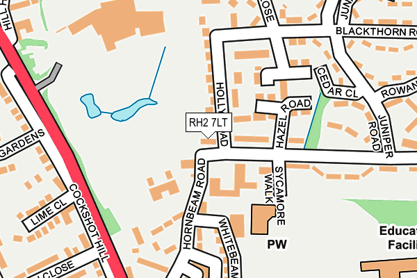
RH2 7LT is located in the South Park & Woodhatch electoral ward, within the local authority district of Reigate and Banstead and the English Parliamentary constituency of Reigate. The Sub Integrated Care Board (ICB) Location is NHS Surrey Heartlands ICB - 92A and the police force is Surrey. This postcode has been in use since January 1980.


GetTheData
Source: OS OpenMap – Local (Ordnance Survey)
Source: OS VectorMap District (Ordnance Survey)
Licence: Open Government Licence (requires attribution)
| Easting | 525959 |
| Northing | 148988 |
| Latitude | 51.226194 |
| Longitude | -0.197521 |
GetTheData
Source: Open Postcode Geo
Licence: Open Government Licence
| Country | England |
| Postcode District | RH2 |
➜ See where RH2 is on a map ➜ Where is Redhill? | |
GetTheData
Source: Land Registry Price Paid Data
Licence: Open Government Licence
Elevation or altitude of RH2 7LT as distance above sea level:
| Metres | Feet | |
|---|---|---|
| Elevation | 70m | 230ft |
Elevation is measured from the approximate centre of the postcode, to the nearest point on an OS contour line from OS Terrain 50, which has contour spacing of ten vertical metres.
➜ How high above sea level am I? Find the elevation of your current position using your device's GPS.
GetTheData
Source: Open Postcode Elevation
Licence: Open Government Licence
| Ward | South Park & Woodhatch |
| Constituency | Reigate |
GetTheData
Source: ONS Postcode Database
Licence: Open Government Licence
| Holly Road | Woodhatch | 75m |
| Holly Road | Woodhatch | 79m |
| Hornbeam Road | Woodhatch | 111m |
| Angel Place (Cockshot Hill) | Woodhatch | 209m |
| Angel Place (Cockshot Hill) | Woodhatch | 217m |
| Reigate Station | 1.8km |
| Earlswood (Surrey) Station | 1.9km |
| Redhill Station | 2.7km |
GetTheData
Source: NaPTAN
Licence: Open Government Licence
| Percentage of properties with Next Generation Access | 100.0% |
| Percentage of properties with Superfast Broadband | 100.0% |
| Percentage of properties with Ultrafast Broadband | 100.0% |
| Percentage of properties with Full Fibre Broadband | 0.0% |
Superfast Broadband is between 30Mbps and 300Mbps
Ultrafast Broadband is > 300Mbps
| Percentage of properties unable to receive 2Mbps | 0.0% |
| Percentage of properties unable to receive 5Mbps | 0.0% |
| Percentage of properties unable to receive 10Mbps | 0.0% |
| Percentage of properties unable to receive 30Mbps | 0.0% |
GetTheData
Source: Ofcom
Licence: Ofcom Terms of Use (requires attribution)
GetTheData
Source: ONS Postcode Database
Licence: Open Government Licence


➜ Get more ratings from the Food Standards Agency
GetTheData
Source: Food Standards Agency
Licence: FSA terms & conditions
| Last Collection | |||
|---|---|---|---|
| Location | Mon-Fri | Sat | Distance |
| Hornbeam Road | 17:30 | 12:15 | 211m |
| Broadhurst Gardens | 17:30 | 12:30 | 266m |
| Wood Hatch | 17:15 | 12:15 | 320m |
GetTheData
Source: Dracos
Licence: Creative Commons Attribution-ShareAlike
The below table lists the International Territorial Level (ITL) codes (formerly Nomenclature of Territorial Units for Statistics (NUTS) codes) and Local Administrative Units (LAU) codes for RH2 7LT:
| ITL 1 Code | Name |
|---|---|
| TLJ | South East (England) |
| ITL 2 Code | Name |
| TLJ2 | Surrey, East and West Sussex |
| ITL 3 Code | Name |
| TLJ26 | East Surrey |
| LAU 1 Code | Name |
| E07000211 | Reigate and Banstead |
GetTheData
Source: ONS Postcode Directory
Licence: Open Government Licence
The below table lists the Census Output Area (OA), Lower Layer Super Output Area (LSOA), and Middle Layer Super Output Area (MSOA) for RH2 7LT:
| Code | Name | |
|---|---|---|
| OA | E00156045 | |
| LSOA | E01030594 | Reigate and Banstead 013A |
| MSOA | E02006387 | Reigate and Banstead 013 |
GetTheData
Source: ONS Postcode Directory
Licence: Open Government Licence
| RH2 7NW | Hornbeam Road | 58m |
| RH2 7LU | Holly Road | 106m |
| RH2 7LR | Sycamore Walk | 110m |
| RH2 7LY | Hazel Road | 125m |
| RH2 7LN | Hornbeam Road | 132m |
| RH2 7LX | Blackthorn Road | 147m |
| RH2 8AJ | Angel Place | 177m |
| RH2 7LL | Trehaven Parade | 178m |
| RH2 7LJ | Woodhatch Road | 199m |
| RH2 7NA | Blackthorn Road | 205m |
GetTheData
Source: Open Postcode Geo; Land Registry Price Paid Data
Licence: Open Government Licence