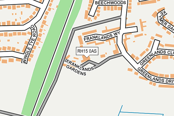
RH15 0AS lies on Greenlands Drive in Burgess Hill. RH15 0AS is located in the Burgess Hill Franklands electoral ward, within the local authority district of Mid Sussex and the English Parliamentary constituency of Mid Sussex. The Sub Integrated Care Board (ICB) Location is NHS Sussex ICB - 70F and the police force is Sussex. This postcode has been in use since January 1980.


GetTheData
Source: OS OpenMap – Local (Ordnance Survey)
Source: OS VectorMap District (Ordnance Survey)
Licence: Open Government Licence (requires attribution)
| Easting | 531415 |
| Northing | 117922 |
| Latitude | 50.945766 |
| Longitude | -0.130719 |
GetTheData
Source: Open Postcode Geo
Licence: Open Government Licence
| Street | Greenlands Drive |
| Town/City | Burgess Hill |
| Country | England |
| Postcode District | RH15 |
➜ See where RH15 is on a map ➜ Where is Burgess Hill? | |
GetTheData
Source: Land Registry Price Paid Data
Licence: Open Government Licence
Elevation or altitude of RH15 0AS as distance above sea level:
| Metres | Feet | |
|---|---|---|
| Elevation | 60m | 197ft |
Elevation is measured from the approximate centre of the postcode, to the nearest point on an OS contour line from OS Terrain 50, which has contour spacing of ten vertical metres.
➜ How high above sea level am I? Find the elevation of your current position using your device's GPS.
GetTheData
Source: Open Postcode Elevation
Licence: Open Government Licence
| Ward | Burgess Hill Franklands |
| Constituency | Mid Sussex |
GetTheData
Source: ONS Postcode Database
Licence: Open Government Licence
| Wingle Tye Road (Chanctonbury Road) | Burgess Hill | 215m |
| Wingle Tye Road (Chanctonbury Road) | Burgess Hill | 238m |
| Holmesdale Road (Chanctonbury Road) | Burgess Hill | 303m |
| Holmesdale Road (Chanctonbury Road) | Burgess Hill | 323m |
| Greenlands Drive (Keymer Road) | Burgess Hill | 384m |
| Burgess Hill Station | 0.9km |
| Wivelsfield Station | 2.2km |
| Hassocks Station | 2.6km |
GetTheData
Source: NaPTAN
Licence: Open Government Licence
| Percentage of properties with Next Generation Access | 100.0% |
| Percentage of properties with Superfast Broadband | 100.0% |
| Percentage of properties with Ultrafast Broadband | 0.0% |
| Percentage of properties with Full Fibre Broadband | 0.0% |
Superfast Broadband is between 30Mbps and 300Mbps
Ultrafast Broadband is > 300Mbps
| Percentage of properties unable to receive 2Mbps | 0.0% |
| Percentage of properties unable to receive 5Mbps | 0.0% |
| Percentage of properties unable to receive 10Mbps | 0.0% |
| Percentage of properties unable to receive 30Mbps | 0.0% |
GetTheData
Source: Ofcom
Licence: Ofcom Terms of Use (requires attribution)
Estimated total energy consumption in RH15 0AS by fuel type, 2015.
| Consumption (kWh) | 154,721 |
|---|---|
| Meter count | 9 |
| Mean (kWh/meter) | 17,191 |
| Median (kWh/meter) | 15,734 |
| Consumption (kWh) | 28,307 |
|---|---|
| Meter count | 10 |
| Mean (kWh/meter) | 2,831 |
| Median (kWh/meter) | 2,386 |
GetTheData
Source: Postcode level gas estimates: 2015 (experimental)
Source: Postcode level electricity estimates: 2015 (experimental)
Licence: Open Government Licence
GetTheData
Source: ONS Postcode Database
Licence: Open Government Licence


➜ Get more ratings from the Food Standards Agency
GetTheData
Source: Food Standards Agency
Licence: FSA terms & conditions
| Last Collection | |||
|---|---|---|---|
| Location | Mon-Fri | Sat | Distance |
| Chanctonbury Road | 17:00 | 12:00 | 212m |
| Keymer Road | 17:00 | 11:00 | 533m |
| Holmesdale Road | 17:00 | 12:00 | 539m |
GetTheData
Source: Dracos
Licence: Creative Commons Attribution-ShareAlike
The below table lists the International Territorial Level (ITL) codes (formerly Nomenclature of Territorial Units for Statistics (NUTS) codes) and Local Administrative Units (LAU) codes for RH15 0AS:
| ITL 1 Code | Name |
|---|---|
| TLJ | South East (England) |
| ITL 2 Code | Name |
| TLJ2 | Surrey, East and West Sussex |
| ITL 3 Code | Name |
| TLJ28 | West Sussex (North East) |
| LAU 1 Code | Name |
| E07000228 | Mid Sussex |
GetTheData
Source: ONS Postcode Directory
Licence: Open Government Licence
The below table lists the Census Output Area (OA), Lower Layer Super Output Area (LSOA), and Middle Layer Super Output Area (MSOA) for RH15 0AS:
| Code | Name | |
|---|---|---|
| OA | E00161663 | |
| LSOA | E01031703 | Mid Sussex 015B |
| MSOA | E02006618 | Mid Sussex 015 |
GetTheData
Source: ONS Postcode Directory
Licence: Open Government Licence
| RH15 0UJ | Franklands Gardens | 79m |
| RH15 0AX | Franklands Way | 102m |
| RH15 9HR | Wingle Tye Road | 186m |
| RH15 0DE | Beechwoods | 193m |
| RH15 9HE | Chanctonbury Road | 209m |
| RH15 0AY | Franklands Close | 215m |
| RH15 9HP | Wingle Tye Road | 218m |
| RH15 0AZ | Greenlands Drive | 227m |
| RH15 0DF | Beechwoods | 229m |
| RH15 9HN | Chanctonbury Road | 268m |
GetTheData
Source: Open Postcode Geo; Land Registry Price Paid Data
Licence: Open Government Licence