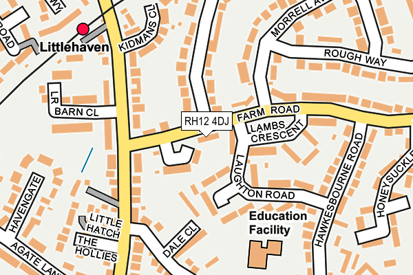
RH12 4DJ lies on Lambs Farm Road in Horsham. RH12 4DJ is located in the Roffey North electoral ward, within the local authority district of Horsham and the English Parliamentary constituency of Horsham. The Sub Integrated Care Board (ICB) Location is NHS Sussex ICB - 70F and the police force is Sussex. This postcode has been in use since January 1980.


GetTheData
Source: OS OpenMap – Local (Ordnance Survey)
Source: OS VectorMap District (Ordnance Survey)
Licence: Open Government Licence (requires attribution)
| Easting | 518781 |
| Northing | 132336 |
| Latitude | 51.078063 |
| Longitude | -0.305758 |
GetTheData
Source: Open Postcode Geo
Licence: Open Government Licence
| Street | Lambs Farm Road |
| Town/City | Horsham |
| Country | England |
| Postcode District | RH12 |
➜ See where RH12 is on a map ➜ Where is Horsham? | |
GetTheData
Source: Land Registry Price Paid Data
Licence: Open Government Licence
Elevation or altitude of RH12 4DJ as distance above sea level:
| Metres | Feet | |
|---|---|---|
| Elevation | 70m | 230ft |
Elevation is measured from the approximate centre of the postcode, to the nearest point on an OS contour line from OS Terrain 50, which has contour spacing of ten vertical metres.
➜ How high above sea level am I? Find the elevation of your current position using your device's GPS.
GetTheData
Source: Open Postcode Elevation
Licence: Open Government Licence
| Ward | Roffey North |
| Constituency | Horsham |
GetTheData
Source: ONS Postcode Database
Licence: Open Government Licence
| Luxford Close (Lambs Farm Road) | Littlehaven | 38m |
| Luxford Close (Lambs Farm Road) | Littlehaven | 95m |
| Littlehaven Station (Rusper Road) | Littlehaven | 157m |
| Littlehaven Station (Rusper Road) | Littlehaven | 198m |
| Littlehaven Lane (Rusper Road) | Littlehaven | 209m |
| Littlehaven Station | 0.2km |
| Horsham Station | 1.6km |
| Warnham Station | 2.3km |
GetTheData
Source: NaPTAN
Licence: Open Government Licence
| Percentage of properties with Next Generation Access | 100.0% |
| Percentage of properties with Superfast Broadband | 100.0% |
| Percentage of properties with Ultrafast Broadband | 0.0% |
| Percentage of properties with Full Fibre Broadband | 0.0% |
Superfast Broadband is between 30Mbps and 300Mbps
Ultrafast Broadband is > 300Mbps
| Percentage of properties unable to receive 2Mbps | 0.0% |
| Percentage of properties unable to receive 5Mbps | 0.0% |
| Percentage of properties unable to receive 10Mbps | 0.0% |
| Percentage of properties unable to receive 30Mbps | 0.0% |
GetTheData
Source: Ofcom
Licence: Ofcom Terms of Use (requires attribution)
GetTheData
Source: ONS Postcode Database
Licence: Open Government Licence


➜ Get more ratings from the Food Standards Agency
GetTheData
Source: Food Standards Agency
Licence: FSA terms & conditions
| Last Collection | |||
|---|---|---|---|
| Location | Mon-Fri | Sat | Distance |
| Littlehaven Halt | 16:30 | 12:00 | 172m |
| Hawkesbourne Road | 17:00 | 12:00 | 224m |
| Littlehaven P O | 16:30 | 12:00 | 274m |
GetTheData
Source: Dracos
Licence: Creative Commons Attribution-ShareAlike
The below table lists the International Territorial Level (ITL) codes (formerly Nomenclature of Territorial Units for Statistics (NUTS) codes) and Local Administrative Units (LAU) codes for RH12 4DJ:
| ITL 1 Code | Name |
|---|---|
| TLJ | South East (England) |
| ITL 2 Code | Name |
| TLJ2 | Surrey, East and West Sussex |
| ITL 3 Code | Name |
| TLJ28 | West Sussex (North East) |
| LAU 1 Code | Name |
| E07000227 | Horsham |
GetTheData
Source: ONS Postcode Directory
Licence: Open Government Licence
The below table lists the Census Output Area (OA), Lower Layer Super Output Area (LSOA), and Middle Layer Super Output Area (MSOA) for RH12 4DJ:
| Code | Name | |
|---|---|---|
| OA | E00161485 | |
| LSOA | E01031668 | Horsham 002H |
| MSOA | E02006589 | Horsham 002 |
GetTheData
Source: ONS Postcode Directory
Licence: Open Government Licence
| RH12 4DL | Luxford Close | 58m |
| RH12 4BS | Lambs Farm Road | 65m |
| RH12 4EJ | Laughton Road | 117m |
| RH12 4DH | Lambs Crescent | 119m |
| RH12 4EL | Laughton Road | 127m |
| RH12 4BN | Rusper Road | 130m |
| RH12 4BW | Rusper Road | 135m |
| RH12 4JD | Dale Close | 149m |
| RH12 4BP | Rusper Road | 151m |
| RH12 4AY | Kidmans Close | 168m |
GetTheData
Source: Open Postcode Geo; Land Registry Price Paid Data
Licence: Open Government Licence