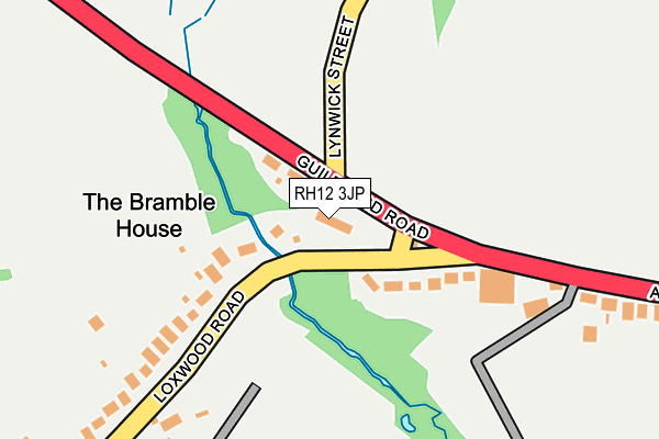
RH12 3JP is located in the Rudgwick electoral ward, within the local authority district of Horsham and the English Parliamentary constituency of Horsham. The Sub Integrated Care Board (ICB) Location is NHS Sussex ICB - 70F and the police force is Sussex. This postcode has been in use since January 1980.


GetTheData
Source: OS OpenMap – Local (Ordnance Survey)
Source: OS VectorMap District (Ordnance Survey)
Licence: Open Government Licence (requires attribution)
| Easting | 507775 |
| Northing | 133006 |
| Latitude | 51.086256 |
| Longitude | -0.462607 |
GetTheData
Source: Open Postcode Geo
Licence: Open Government Licence
| Country | England |
| Postcode District | RH12 |
➜ See where RH12 is on a map | |
GetTheData
Source: Land Registry Price Paid Data
Licence: Open Government Licence
Elevation or altitude of RH12 3JP as distance above sea level:
| Metres | Feet | |
|---|---|---|
| Elevation | 30m | 98ft |
Elevation is measured from the approximate centre of the postcode, to the nearest point on an OS contour line from OS Terrain 50, which has contour spacing of ten vertical metres.
➜ How high above sea level am I? Find the elevation of your current position using your device's GPS.
GetTheData
Source: Open Postcode Elevation
Licence: Open Government Licence
| Ward | Rudgwick |
| Constituency | Horsham |
GetTheData
Source: ONS Postcode Database
Licence: Open Government Licence
| The Fox Ph (Guildford Rd) | Bucks Green | 64m |
| Queens Head (Guildford Road) | Bucks Green | 349m |
| Queens Head (Guildford Road) | Bucks Green | 388m |
| Watts Corner (Guildford Road) | Rudgwick | 652m |
| Watts Corner (Guildford Road) | Rudgwick | 668m |
GetTheData
Source: NaPTAN
Licence: Open Government Licence
| Percentage of properties with Next Generation Access | 100.0% |
| Percentage of properties with Superfast Broadband | 100.0% |
| Percentage of properties with Ultrafast Broadband | 0.0% |
| Percentage of properties with Full Fibre Broadband | 0.0% |
Superfast Broadband is between 30Mbps and 300Mbps
Ultrafast Broadband is > 300Mbps
| Percentage of properties unable to receive 2Mbps | 0.0% |
| Percentage of properties unable to receive 5Mbps | 0.0% |
| Percentage of properties unable to receive 10Mbps | 0.0% |
| Percentage of properties unable to receive 30Mbps | 0.0% |
GetTheData
Source: Ofcom
Licence: Ofcom Terms of Use (requires attribution)
GetTheData
Source: ONS Postcode Database
Licence: Open Government Licence


➜ Get more ratings from the Food Standards Agency
GetTheData
Source: Food Standards Agency
Licence: FSA terms & conditions
| Last Collection | |||
|---|---|---|---|
| Location | Mon-Fri | Sat | Distance |
| Bucks Green | 16:30 | 07:00 | 14m |
| Tismans Common | 16:45 | 07:00 | 692m |
| Queen Elizabeth Road | 16:30 | 09:00 | 768m |
GetTheData
Source: Dracos
Licence: Creative Commons Attribution-ShareAlike
The below table lists the International Territorial Level (ITL) codes (formerly Nomenclature of Territorial Units for Statistics (NUTS) codes) and Local Administrative Units (LAU) codes for RH12 3JP:
| ITL 1 Code | Name |
|---|---|
| TLJ | South East (England) |
| ITL 2 Code | Name |
| TLJ2 | Surrey, East and West Sussex |
| ITL 3 Code | Name |
| TLJ28 | West Sussex (North East) |
| LAU 1 Code | Name |
| E07000227 | Horsham |
GetTheData
Source: ONS Postcode Directory
Licence: Open Government Licence
The below table lists the Census Output Area (OA), Lower Layer Super Output Area (LSOA), and Middle Layer Super Output Area (MSOA) for RH12 3JP:
| Code | Name | |
|---|---|---|
| OA | E00161529 | |
| LSOA | E01031674 | Horsham 005C |
| MSOA | E02006592 | Horsham 005 |
GetTheData
Source: ONS Postcode Directory
Licence: Open Government Licence
| RH12 3JW | Loxwood Road | 112m |
| RH12 3JJ | Bucks Green | 279m |
| RH12 3DW | Loxwood Road | 296m |
| RH12 3JF | Bucks Green | 438m |
| RH12 3JE | Bucks Green | 520m |
| RH12 3HA | Church Street | 525m |
| RH12 3DR | Loxwood Road | 617m |
| RH12 3EQ | Orchard Hill | 620m |
| RH12 3HJ | Church Street | 701m |
| RH12 3DS | Loxwood Road | 710m |
GetTheData
Source: Open Postcode Geo; Land Registry Price Paid Data
Licence: Open Government Licence