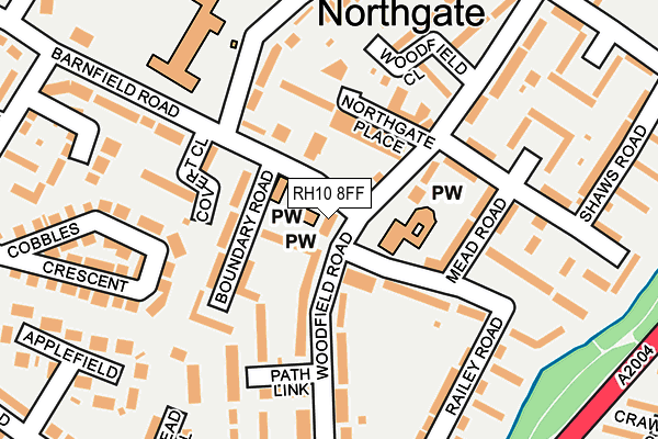
RH10 8FF is located in the Northgate & West Green electoral ward, within the local authority district of Crawley and the English Parliamentary constituency of Crawley. The Sub Integrated Care Board (ICB) Location is NHS Sussex ICB - 70F and the police force is Sussex. This postcode has been in use since November 2009.


GetTheData
Source: OS OpenMap – Local (Ordnance Survey)
Source: OS VectorMap District (Ordnance Survey)
Licence: Open Government Licence (requires attribution)
| Easting | 527372 |
| Northing | 137261 |
| Latitude | 51.120485 |
| Longitude | -0.181448 |
GetTheData
Source: Open Postcode Geo
Licence: Open Government Licence
| Country | England |
| Postcode District | RH10 |
➜ See where RH10 is on a map ➜ Where is Crawley? | |
GetTheData
Source: Land Registry Price Paid Data
Licence: Open Government Licence
Elevation or altitude of RH10 8FF as distance above sea level:
| Metres | Feet | |
|---|---|---|
| Elevation | 70m | 230ft |
Elevation is measured from the approximate centre of the postcode, to the nearest point on an OS contour line from OS Terrain 50, which has contour spacing of ten vertical metres.
➜ How high above sea level am I? Find the elevation of your current position using your device's GPS.
GetTheData
Source: Open Postcode Elevation
Licence: Open Government Licence
| Ward | Northgate & West Green |
| Constituency | Crawley |
GetTheData
Source: ONS Postcode Database
Licence: Open Government Licence
| Northgate Parade (Woodfield Road) | Northgate | 62m |
| Northgate Parade (Woodfield Road) | Northgate | 73m |
| Northgate Avenue Central (Northgate Avenue) | Crawley | 292m |
| Northgate Avenue Central (Northgate Avenue) | Crawley | 306m |
| Exchange Road | Crawley | 317m |
| Crawley Station | 1km |
| Three Bridges Station | 1.5km |
| Ifield Station | 2.4km |
GetTheData
Source: NaPTAN
Licence: Open Government Licence
GetTheData
Source: ONS Postcode Database
Licence: Open Government Licence


➜ Get more ratings from the Food Standards Agency
GetTheData
Source: Food Standards Agency
Licence: FSA terms & conditions
| Last Collection | |||
|---|---|---|---|
| Location | Mon-Fri | Sat | Distance |
| Northgate Parade | 17:30 | 11:00 | 71m |
| Woolborough Road | 17:30 | 11:00 | 396m |
| Oakway | 17:30 | 11:00 | 439m |
GetTheData
Source: Dracos
Licence: Creative Commons Attribution-ShareAlike
The below table lists the International Territorial Level (ITL) codes (formerly Nomenclature of Territorial Units for Statistics (NUTS) codes) and Local Administrative Units (LAU) codes for RH10 8FF:
| ITL 1 Code | Name |
|---|---|
| TLJ | South East (England) |
| ITL 2 Code | Name |
| TLJ2 | Surrey, East and West Sussex |
| ITL 3 Code | Name |
| TLJ28 | West Sussex (North East) |
| LAU 1 Code | Name |
| E07000226 | Crawley |
GetTheData
Source: ONS Postcode Directory
Licence: Open Government Licence
The below table lists the Census Output Area (OA), Lower Layer Super Output Area (LSOA), and Middle Layer Super Output Area (MSOA) for RH10 8FF:
| Code | Name | |
|---|---|---|
| OA | E00161068 | |
| LSOA | E01031584 | Crawley 004B |
| MSOA | E02006578 | Crawley 004 |
GetTheData
Source: ONS Postcode Directory
Licence: Open Government Licence
| RH10 8BU | Boundary Close | 39m |
| RH10 8DT | The Parade | 88m |
| RH10 8DD | Railey Road | 107m |
| RH10 8BT | Boundary Road | 109m |
| RH10 8EP | Woodfield Road | 123m |
| RH10 8BX | Woodfield Road | 124m |
| RH10 8DE | Mead Road | 133m |
| RH10 8BP | Crosspath | 134m |
| RH10 8DR | Covert Close | 143m |
| RH10 8DU | Hollybush Road | 152m |
GetTheData
Source: Open Postcode Geo; Land Registry Price Paid Data
Licence: Open Government Licence