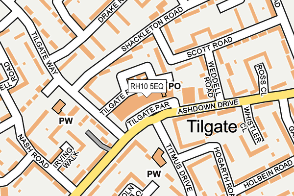
RH10 5EQ is located in the Tilgate electoral ward, within the local authority district of Crawley and the English Parliamentary constituency of Crawley. The Sub Integrated Care Board (ICB) Location is NHS Sussex ICB - 70F and the police force is Sussex. This postcode has been in use since January 1980.


GetTheData
Source: OS OpenMap – Local (Ordnance Survey)
Source: OS VectorMap District (Ordnance Survey)
Licence: Open Government Licence (requires attribution)
| Easting | 527480 |
| Northing | 135235 |
| Latitude | 51.102249 |
| Longitude | -0.180593 |
GetTheData
Source: Open Postcode Geo
Licence: Open Government Licence
| Country | England |
| Postcode District | RH10 |
➜ See where RH10 is on a map ➜ Where is Crawley? | |
GetTheData
Source: Land Registry Price Paid Data
Licence: Open Government Licence
Elevation or altitude of RH10 5EQ as distance above sea level:
| Metres | Feet | |
|---|---|---|
| Elevation | 80m | 262ft |
Elevation is measured from the approximate centre of the postcode, to the nearest point on an OS contour line from OS Terrain 50, which has contour spacing of ten vertical metres.
➜ How high above sea level am I? Find the elevation of your current position using your device's GPS.
GetTheData
Source: Open Postcode Elevation
Licence: Open Government Licence
| Ward | Tilgate |
| Constituency | Crawley |
GetTheData
Source: ONS Postcode Database
Licence: Open Government Licence
| Tilgate Place (Tilgate Way) | Tilgate | 84m |
| Tilgate Place (Tilgate Way) | Tilgate | 115m |
| Whistler Close (Ashdown Drive) | Tilgate | 156m |
| Nash Road (Ashdown Drive) | Tilgate | 196m |
| Whistler Close (Ashdown Drive) | Tilgate | 198m |
| Crawley Station | 1.2km |
| Three Bridges Station | 2.1km |
| Ifield Station | 2.8km |
GetTheData
Source: NaPTAN
Licence: Open Government Licence
| Median download speed | 8.2Mbps |
| Average download speed | 14.8Mbps |
| Maximum download speed | 39.95Mbps |
| Median upload speed | 1.0Mbps |
| Average upload speed | 3.6Mbps |
| Maximum upload speed | 8.92Mbps |
GetTheData
Source: Ofcom
Licence: Ofcom Terms of Use (requires attribution)
GetTheData
Source: ONS Postcode Database
Licence: Open Government Licence


➜ Get more ratings from the Food Standards Agency
GetTheData
Source: Food Standards Agency
Licence: FSA terms & conditions
| Last Collection | |||
|---|---|---|---|
| Location | Mon-Fri | Sat | Distance |
| Tilgate Parade P O | 17:15 | 11:45 | 41m |
| Cook Road | 17:30 | 11:15 | 269m |
| Nash Road | 17:30 | 11:15 | 295m |
GetTheData
Source: Dracos
Licence: Creative Commons Attribution-ShareAlike
The below table lists the International Territorial Level (ITL) codes (formerly Nomenclature of Territorial Units for Statistics (NUTS) codes) and Local Administrative Units (LAU) codes for RH10 5EQ:
| ITL 1 Code | Name |
|---|---|
| TLJ | South East (England) |
| ITL 2 Code | Name |
| TLJ2 | Surrey, East and West Sussex |
| ITL 3 Code | Name |
| TLJ28 | West Sussex (North East) |
| LAU 1 Code | Name |
| E07000226 | Crawley |
GetTheData
Source: ONS Postcode Directory
Licence: Open Government Licence
The below table lists the Census Output Area (OA), Lower Layer Super Output Area (LSOA), and Middle Layer Super Output Area (MSOA) for RH10 5EQ:
| Code | Name | |
|---|---|---|
| OA | E00161182 | |
| LSOA | E01031604 | Crawley 011B |
| MSOA | E02006585 | Crawley 011 |
GetTheData
Source: ONS Postcode Directory
Licence: Open Government Licence
| RH10 5BY | Scott Road | 75m |
| RH10 5BX | Shackleton Road | 97m |
| RH10 5EL | Titmus Drive | 99m |
| RH10 5BU | Tilgate Way | 109m |
| RH10 5DU | Ashdown Drive | 141m |
| RH10 5JY | Hogarth Road | 144m |
| RH10 5NF | Drake Road | 160m |
| RH10 5DD | Scott Road | 167m |
| RH10 5EG | Ashdown Drive | 178m |
| RH10 5EX | Ashdown Drive | 179m |
GetTheData
Source: Open Postcode Geo; Land Registry Price Paid Data
Licence: Open Government Licence