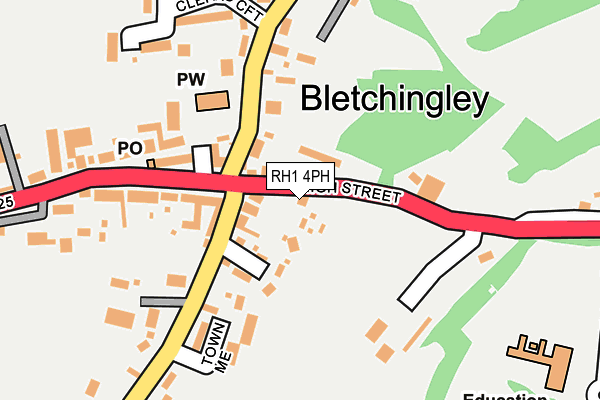
RH1 4PH lies on High Street in Bletchingley, Redhill. RH1 4PH is located in the Bletchingley and Nutfield electoral ward, within the local authority district of Tandridge and the English Parliamentary constituency of East Surrey. The Sub Integrated Care Board (ICB) Location is NHS Surrey Heartlands ICB - 92A and the police force is Surrey. This postcode has been in use since January 1980.


GetTheData
Source: OS OpenMap – Local (Ordnance Survey)
Source: OS VectorMap District (Ordnance Survey)
Licence: Open Government Licence (requires attribution)
| Easting | 532854 |
| Northing | 150729 |
| Latitude | 51.240276 |
| Longitude | -0.098163 |
GetTheData
Source: Open Postcode Geo
Licence: Open Government Licence
| Street | High Street |
| Locality | Bletchingley |
| Town/City | Redhill |
| Country | England |
| Postcode District | RH1 |
➜ See where RH1 is on a map ➜ Where is Bletchingley? | |
GetTheData
Source: Land Registry Price Paid Data
Licence: Open Government Licence
Elevation or altitude of RH1 4PH as distance above sea level:
| Metres | Feet | |
|---|---|---|
| Elevation | 130m | 427ft |
Elevation is measured from the approximate centre of the postcode, to the nearest point on an OS contour line from OS Terrain 50, which has contour spacing of ten vertical metres.
➜ How high above sea level am I? Find the elevation of your current position using your device's GPS.
GetTheData
Source: Open Postcode Elevation
Licence: Open Government Licence
| Ward | Bletchingley And Nutfield |
| Constituency | East Surrey |
GetTheData
Source: ONS Postcode Database
Licence: Open Government Licence
1, HIGH STREET, BLETCHINGLEY, REDHILL, RH1 4PH 2017 10 JUL £665,000 |
1A, HIGH STREET, BLETCHINGLEY, REDHILL, RH1 4PH 1999 27 AUG £289,950 |
GetTheData
Source: HM Land Registry Price Paid Data
Licence: Contains HM Land Registry data © Crown copyright and database right 2025. This data is licensed under the Open Government Licence v3.0.
| White Hart (High Street) | Bletchingley | 129m |
| White Hart (High Street) | Bletchingley | 135m |
| Rabies Heath Road (Godstone Road) | Bletchingley | 351m |
| Rabies Heath Road (Godstone Road) | Bletchingley | 474m |
| Little Common Lane (Castle Street) | Bletchingley | 558m |
| Nutfield Station | 2.8km |
| Godstone Station | 4.2km |
| Merstham Station | 4.5km |
GetTheData
Source: NaPTAN
Licence: Open Government Licence
| Percentage of properties with Next Generation Access | 100.0% |
| Percentage of properties with Superfast Broadband | 100.0% |
| Percentage of properties with Ultrafast Broadband | 0.0% |
| Percentage of properties with Full Fibre Broadband | 0.0% |
Superfast Broadband is between 30Mbps and 300Mbps
Ultrafast Broadband is > 300Mbps
| Percentage of properties unable to receive 2Mbps | 0.0% |
| Percentage of properties unable to receive 5Mbps | 0.0% |
| Percentage of properties unable to receive 10Mbps | 0.0% |
| Percentage of properties unable to receive 30Mbps | 0.0% |
GetTheData
Source: Ofcom
Licence: Ofcom Terms of Use (requires attribution)
GetTheData
Source: ONS Postcode Database
Licence: Open Government Licence


➜ Get more ratings from the Food Standards Agency
GetTheData
Source: Food Standards Agency
Licence: FSA terms & conditions
| Last Collection | |||
|---|---|---|---|
| Location | Mon-Fri | Sat | Distance |
| Bletchingley P O | 17:00 | 11:15 | 182m |
| Whitepost Hill | 17:00 | 09:30 | 361m |
| Stychens Lane | 16:00 | 08:30 | 532m |
GetTheData
Source: Dracos
Licence: Creative Commons Attribution-ShareAlike
The below table lists the International Territorial Level (ITL) codes (formerly Nomenclature of Territorial Units for Statistics (NUTS) codes) and Local Administrative Units (LAU) codes for RH1 4PH:
| ITL 1 Code | Name |
|---|---|
| TLJ | South East (England) |
| ITL 2 Code | Name |
| TLJ2 | Surrey, East and West Sussex |
| ITL 3 Code | Name |
| TLJ26 | East Surrey |
| LAU 1 Code | Name |
| E07000215 | Tandridge |
GetTheData
Source: ONS Postcode Directory
Licence: Open Government Licence
The below table lists the Census Output Area (OA), Lower Layer Super Output Area (LSOA), and Middle Layer Super Output Area (MSOA) for RH1 4PH:
| Code | Name | |
|---|---|---|
| OA | E00157108 | |
| LSOA | E01030815 | Tandridge 008D |
| MSOA | E02006435 | Tandridge 008 |
GetTheData
Source: ONS Postcode Directory
Licence: Open Government Licence
| RH1 4PE | High Street | 48m |
| RH1 4LW | Grange Close | 57m |
| RH1 4LF | St Marys Walk | 64m |
| RH1 4LP | Church Lane | 116m |
| RH1 4LQ | Town Mead | 146m |
| RH1 4PD | Church Walk | 161m |
| RH1 4PB | High Street | 176m |
| RH1 4LR | Outwood Lane | 205m |
| RH1 4PA | High Street | 241m |
| RH1 4LH | Clerks Croft | 257m |
GetTheData
Source: Open Postcode Geo; Land Registry Price Paid Data
Licence: Open Government Licence