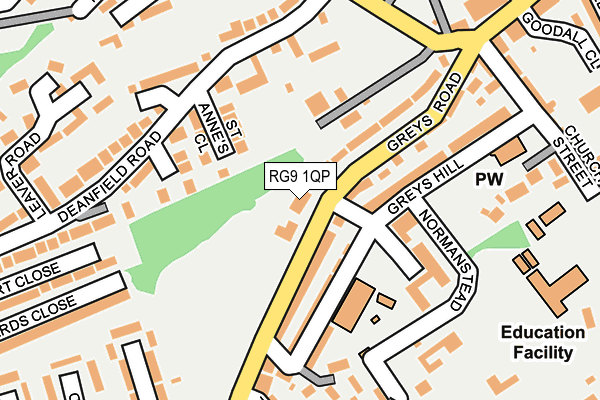
RG9 1QP is located in the Henley-on-Thames electoral ward, within the local authority district of South Oxfordshire and the English Parliamentary constituency of Henley. The Sub Integrated Care Board (ICB) Location is NHS Buckinghamshire, Oxfordshire and Berkshire West ICB - 10Q and the police force is Thames Valley. This postcode has been in use since January 1980.


GetTheData
Source: OS OpenMap – Local (Ordnance Survey)
Source: OS VectorMap District (Ordnance Survey)
Licence: Open Government Licence (requires attribution)
| Easting | 475748 |
| Northing | 182198 |
| Latitude | 51.533616 |
| Longitude | -0.909337 |
GetTheData
Source: Open Postcode Geo
Licence: Open Government Licence
| Country | England |
| Postcode District | RG9 |
➜ See where RG9 is on a map ➜ Where is Henley-on-Thames? | |
GetTheData
Source: Land Registry Price Paid Data
Licence: Open Government Licence
Elevation or altitude of RG9 1QP as distance above sea level:
| Metres | Feet | |
|---|---|---|
| Elevation | 50m | 164ft |
Elevation is measured from the approximate centre of the postcode, to the nearest point on an OS contour line from OS Terrain 50, which has contour spacing of ten vertical metres.
➜ How high above sea level am I? Find the elevation of your current position using your device's GPS.
GetTheData
Source: Open Postcode Elevation
Licence: Open Government Licence
| Ward | Henley-on-thames |
| Constituency | Henley |
GetTheData
Source: ONS Postcode Database
Licence: Open Government Licence
| The Close (Greys Road) | Henley-on-thames | 183m |
| The Close (Greys Road) | Henley-on-thames | 201m |
| Deanfield Road | Henley-on-thames | 217m |
| Deanfield Avenue | Henley-on-thames | 339m |
| Albert Road (Greys Road) | Henley-on-thames | 373m |
| Henley-on-Thames Station | 0.6km |
| Shiplake Station | 3.1km |
| Wargrave Station | 4.6km |
GetTheData
Source: NaPTAN
Licence: Open Government Licence
GetTheData
Source: ONS Postcode Database
Licence: Open Government Licence


➜ Get more ratings from the Food Standards Agency
GetTheData
Source: Food Standards Agency
Licence: FSA terms & conditions
| Last Collection | |||
|---|---|---|---|
| Location | Mon-Fri | Sat | Distance |
| Gravel Hill | 17:15 | 11:00 | 407m |
| Vicarage Road | 17:15 | 11:45 | 446m |
| Henley Delivery Office | 18:30 | 12:30 | 456m |
GetTheData
Source: Dracos
Licence: Creative Commons Attribution-ShareAlike
The below table lists the International Territorial Level (ITL) codes (formerly Nomenclature of Territorial Units for Statistics (NUTS) codes) and Local Administrative Units (LAU) codes for RG9 1QP:
| ITL 1 Code | Name |
|---|---|
| TLJ | South East (England) |
| ITL 2 Code | Name |
| TLJ1 | Berkshire, Buckinghamshire and Oxfordshire |
| ITL 3 Code | Name |
| TLJ14 | Oxfordshire CC |
| LAU 1 Code | Name |
| E07000179 | South Oxfordshire |
GetTheData
Source: ONS Postcode Directory
Licence: Open Government Licence
The below table lists the Census Output Area (OA), Lower Layer Super Output Area (LSOA), and Middle Layer Super Output Area (MSOA) for RG9 1QP:
| Code | Name | |
|---|---|---|
| OA | E00145942 | |
| LSOA | E01028650 | South Oxfordshire 016A |
| MSOA | E02005973 | South Oxfordshire 016 |
GetTheData
Source: ONS Postcode Directory
Licence: Open Government Licence
| RG9 1TE | Greys Road | 76m |
| RG9 1TF | Greys Road | 102m |
| RG9 1GQ | Deanacre | 109m |
| RG9 1XA | St Annes Close | 109m |
| RG9 1SL | Greys Hill | 113m |
| RG9 1UG | Deanfield Road | 139m |
| RG9 1SJ | Greys Hill | 139m |
| RG9 1TD | Greys Road | 176m |
| RG9 1SW | Greys Hill | 192m |
| RG9 1UE | Deanfield Avenue | 213m |
GetTheData
Source: Open Postcode Geo; Land Registry Price Paid Data
Licence: Open Government Licence