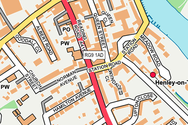
RG9 1AD is located in the Henley-on-Thames electoral ward, within the local authority district of South Oxfordshire and the English Parliamentary constituency of Henley. The Sub Integrated Care Board (ICB) Location is NHS Buckinghamshire, Oxfordshire and Berkshire West ICB - 10Q and the police force is Thames Valley. This postcode has been in use since August 2007.


GetTheData
Source: OS OpenMap – Local (Ordnance Survey)
Source: OS VectorMap District (Ordnance Survey)
Licence: Open Government Licence (requires attribution)
| Easting | 476221 |
| Northing | 182297 |
| Latitude | 51.534443 |
| Longitude | -0.902498 |
GetTheData
Source: Open Postcode Geo
Licence: Open Government Licence
| Country | England |
| Postcode District | RG9 |
➜ See where RG9 is on a map ➜ Where is Henley-on-Thames? | |
GetTheData
Source: Land Registry Price Paid Data
Licence: Open Government Licence
Elevation or altitude of RG9 1AD as distance above sea level:
| Metres | Feet | |
|---|---|---|
| Elevation | 40m | 131ft |
Elevation is measured from the approximate centre of the postcode, to the nearest point on an OS contour line from OS Terrain 50, which has contour spacing of ten vertical metres.
➜ How high above sea level am I? Find the elevation of your current position using your device's GPS.
GetTheData
Source: Open Postcode Elevation
Licence: Open Government Licence
| Ward | Henley-on-thames |
| Constituency | Henley |
GetTheData
Source: ONS Postcode Database
Licence: Open Government Licence
| Norman Avenue (Reading Road) | Henley-on-thames | 24m |
| Henley-on-thames Stn (Station Road) | Henley-on-thames | 106m |
| St Marks Road (Reading Road) | Henley-on-thames | 237m |
| Albert Road (Greys Road) | Henley-on-thames | 252m |
| St Marks Road (Reading Road) | Henley-on-thames | 274m |
| Henley-on-Thames Station | 0.2km |
| Shiplake Station | 2.9km |
| Wargrave Station | 4.4km |
GetTheData
Source: NaPTAN
Licence: Open Government Licence
GetTheData
Source: ONS Postcode Database
Licence: Open Government Licence


➜ Get more ratings from the Food Standards Agency
GetTheData
Source: Food Standards Agency
Licence: FSA terms & conditions
| Last Collection | |||
|---|---|---|---|
| Location | Mon-Fri | Sat | Distance |
| Station Road | 18:15 | 12:00 | 141m |
| Henley Delivery Office | 18:30 | 12:30 | 162m |
| Vicarage Road | 17:15 | 11:45 | 368m |
GetTheData
Source: Dracos
Licence: Creative Commons Attribution-ShareAlike
The below table lists the International Territorial Level (ITL) codes (formerly Nomenclature of Territorial Units for Statistics (NUTS) codes) and Local Administrative Units (LAU) codes for RG9 1AD:
| ITL 1 Code | Name |
|---|---|
| TLJ | South East (England) |
| ITL 2 Code | Name |
| TLJ1 | Berkshire, Buckinghamshire and Oxfordshire |
| ITL 3 Code | Name |
| TLJ14 | Oxfordshire CC |
| LAU 1 Code | Name |
| E07000179 | South Oxfordshire |
GetTheData
Source: ONS Postcode Directory
Licence: Open Government Licence
The below table lists the Census Output Area (OA), Lower Layer Super Output Area (LSOA), and Middle Layer Super Output Area (MSOA) for RG9 1AD:
| Code | Name | |
|---|---|---|
| OA | E00145958 | |
| LSOA | E01028655 | South Oxfordshire 017C |
| MSOA | E02005974 | South Oxfordshire 017 |
GetTheData
Source: ONS Postcode Directory
Licence: Open Government Licence
| RG9 1ER | Norman Avenue | 41m |
| RG9 1AY | Station Road | 50m |
| RG9 1PE | Hamilton Avenue | 71m |
| RG9 1AX | Reading Road | 77m |
| RG9 1AT | Station Road | 80m |
| RG9 1XG | Victoria Court | 96m |
| RG9 1BA | Wyndale Close | 105m |
| RG9 1NP | Imperial Court | 107m |
| RG9 1AB | Reading Road | 117m |
| RG9 1AP | Queen Street | 125m |
GetTheData
Source: Open Postcode Geo; Land Registry Price Paid Data
Licence: Open Government Licence