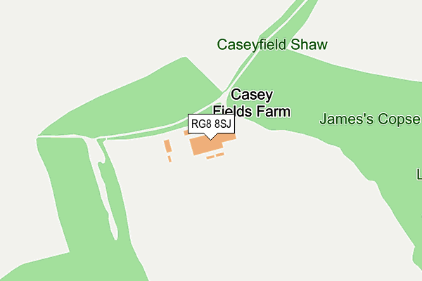
RG8 8SJ is located in the Basildon electoral ward, within the unitary authority of West Berkshire and the English Parliamentary constituency of Newbury. The Sub Integrated Care Board (ICB) Location is NHS Buckinghamshire, Oxfordshire and Berkshire West ICB - 15A and the police force is Thames Valley. This postcode has been in use since October 2003.


GetTheData
Source: OS OpenMap – Local (Ordnance Survey)
Source: OS VectorMap District (Ordnance Survey)
Licence: Open Government Licence (requires attribution)
| Easting | 455978 |
| Northing | 176520 |
| Latitude | 51.484870 |
| Longitude | -1.195225 |
GetTheData
Source: Open Postcode Geo
Licence: Open Government Licence
| Country | England |
| Postcode District | RG8 |
➜ See where RG8 is on a map | |
GetTheData
Source: Land Registry Price Paid Data
Licence: Open Government Licence
Elevation or altitude of RG8 8SJ as distance above sea level:
| Metres | Feet | |
|---|---|---|
| Elevation | 130m | 427ft |
Elevation is measured from the approximate centre of the postcode, to the nearest point on an OS contour line from OS Terrain 50, which has contour spacing of ten vertical metres.
➜ How high above sea level am I? Find the elevation of your current position using your device's GPS.
GetTheData
Source: Open Postcode Elevation
Licence: Open Government Licence
| Ward | Basildon |
| Constituency | Newbury |
GetTheData
Source: ONS Postcode Database
Licence: Open Government Licence
| Goring & Streatley Station | 5.9km |
GetTheData
Source: NaPTAN
Licence: Open Government Licence
GetTheData
Source: ONS Postcode Database
Licence: Open Government Licence


➜ Get more ratings from the Food Standards Agency
GetTheData
Source: Food Standards Agency
Licence: FSA terms & conditions
| Last Collection | |||
|---|---|---|---|
| Location | Mon-Fri | Sat | Distance |
| Hampstead Norreys Post Office | 16:45 | 09:15 | 2,880m |
| Aldworth Post Office | 16:00 | 08:15 | 3,130m |
| Beechfields | 16:15 | 08:45 | 3,604m |
GetTheData
Source: Dracos
Licence: Creative Commons Attribution-ShareAlike
The below table lists the International Territorial Level (ITL) codes (formerly Nomenclature of Territorial Units for Statistics (NUTS) codes) and Local Administrative Units (LAU) codes for RG8 8SJ:
| ITL 1 Code | Name |
|---|---|
| TLJ | South East (England) |
| ITL 2 Code | Name |
| TLJ1 | Berkshire, Buckinghamshire and Oxfordshire |
| ITL 3 Code | Name |
| TLJ11 | Berkshire |
| LAU 1 Code | Name |
| E06000037 | West Berkshire |
GetTheData
Source: ONS Postcode Directory
Licence: Open Government Licence
The below table lists the Census Output Area (OA), Lower Layer Super Output Area (LSOA), and Middle Layer Super Output Area (MSOA) for RG8 8SJ:
| Code | Name | |
|---|---|---|
| OA | E00082262 | |
| LSOA | E01016285 | West Berkshire 007E |
| MSOA | E02003373 | West Berkshire 007 |
GetTheData
Source: ONS Postcode Directory
Licence: Open Government Licence
| RG8 8SL | Pinfold Lane | 531m |
| RG8 8SH | Pinfold Lane | 580m |
| RG8 8RT | 694m | |
| RG8 8SG | Flowers Piece | 767m |
| RG8 8RU | 774m | |
| RG8 8RR | 838m | |
| RG8 8RS | Lower Church Cottages | 876m |
| RG8 8RY | 939m | |
| RG18 0TP | 1067m | |
| RG8 8RP | Stubbles | 1296m |
GetTheData
Source: Open Postcode Geo; Land Registry Price Paid Data
Licence: Open Government Licence