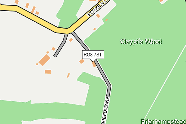
RG8 7ST lies on Eastfield Lane in Goring Heath, Reading. RG8 7ST is located in the Kidmore End & Whitchurch electoral ward, within the local authority district of South Oxfordshire and the English Parliamentary constituency of Henley. The Sub Integrated Care Board (ICB) Location is NHS Buckinghamshire, Oxfordshire and Berkshire West ICB - 10Q and the police force is Thames Valley. This postcode has been in use since January 1980.


GetTheData
Source: OS OpenMap – Local (Ordnance Survey)
Source: OS VectorMap District (Ordnance Survey)
Licence: Open Government Licence (requires attribution)
| Easting | 464353 |
| Northing | 180847 |
| Latitude | 51.522882 |
| Longitude | -1.073840 |
GetTheData
Source: Open Postcode Geo
Licence: Open Government Licence
| Street | Eastfield Lane |
| Locality | Goring Heath |
| Town/City | Reading |
| Country | England |
| Postcode District | RG8 |
➜ See where RG8 is on a map ➜ Where is Woodcote? | |
GetTheData
Source: Land Registry Price Paid Data
Licence: Open Government Licence
Elevation or altitude of RG8 7ST as distance above sea level:
| Metres | Feet | |
|---|---|---|
| Elevation | 170m | 558ft |
Elevation is measured from the approximate centre of the postcode, to the nearest point on an OS contour line from OS Terrain 50, which has contour spacing of ten vertical metres.
➜ How high above sea level am I? Find the elevation of your current position using your device's GPS.
GetTheData
Source: Open Postcode Elevation
Licence: Open Government Licence
| Ward | Kidmore End & Whitchurch |
| Constituency | Henley |
GetTheData
Source: ONS Postcode Database
Licence: Open Government Licence
POTKILN COTTAGE, EASTFIELD LANE, GORING HEATH, READING, RG8 7ST 2009 1 JUL £388,000 |
THE POT HOLE, EASTFIELD LANE, GORING HEATH, READING, RG8 7ST 2006 1 DEC £451,500 |
POTKILN COTTAGE, EASTFIELD LANE, GORING HEATH, READING, RG8 7ST 2003 10 DEC £410,000 |
POTKILN COTTAGE, EASTFIELD LANE, GORING HEATH, READING, RG8 7ST 2002 15 MAR £110,000 |
POTKILN COTTAGE, EASTFIELD LANE, GORING HEATH, READING, RG8 7ST 2000 14 APR £275,000 |
POTKILN COTTAGE, EASTFIELD LANE, GORING HEATH, READING, RG8 7ST 1995 18 AUG £123,500 |
GetTheData
Source: HM Land Registry Price Paid Data
Licence: Contains HM Land Registry data © Crown copyright and database right 2025. This data is licensed under the Open Government Licence v3.0.
| Bridle Path | Woodcote | 632m |
| Bridle Path | Woodcote | 642m |
| White Lion Ph (Goring Road) | Crays Pond | 653m |
| White Lion Ph (Goring Road) | Crays Pond | 659m |
| Goring Road (Reading Road) | Crays Pond | 713m |
| Goring & Streatley Station | 4.1km |
| Pangbourne Station | 4.3km |
GetTheData
Source: NaPTAN
Licence: Open Government Licence
| Percentage of properties with Next Generation Access | 100.0% |
| Percentage of properties with Superfast Broadband | 100.0% |
| Percentage of properties with Ultrafast Broadband | 0.0% |
| Percentage of properties with Full Fibre Broadband | 0.0% |
Superfast Broadband is between 30Mbps and 300Mbps
Ultrafast Broadband is > 300Mbps
| Percentage of properties unable to receive 2Mbps | 0.0% |
| Percentage of properties unable to receive 5Mbps | 0.0% |
| Percentage of properties unable to receive 10Mbps | 0.0% |
| Percentage of properties unable to receive 30Mbps | 0.0% |
GetTheData
Source: Ofcom
Licence: Ofcom Terms of Use (requires attribution)
GetTheData
Source: ONS Postcode Database
Licence: Open Government Licence


➜ Get more ratings from the Food Standards Agency
GetTheData
Source: Food Standards Agency
Licence: FSA terms & conditions
| Last Collection | |||
|---|---|---|---|
| Location | Mon-Fri | Sat | Distance |
| Crays Pond | 16:15 | 09:45 | 653m |
| Goring Heath | 16:30 | 08:00 | 1,563m |
| Exlade Street | 16:00 | 07:00 | 1,877m |
GetTheData
Source: Dracos
Licence: Creative Commons Attribution-ShareAlike
The below table lists the International Territorial Level (ITL) codes (formerly Nomenclature of Territorial Units for Statistics (NUTS) codes) and Local Administrative Units (LAU) codes for RG8 7ST:
| ITL 1 Code | Name |
|---|---|
| TLJ | South East (England) |
| ITL 2 Code | Name |
| TLJ1 | Berkshire, Buckinghamshire and Oxfordshire |
| ITL 3 Code | Name |
| TLJ14 | Oxfordshire CC |
| LAU 1 Code | Name |
| E07000179 | South Oxfordshire |
GetTheData
Source: ONS Postcode Directory
Licence: Open Government Licence
The below table lists the Census Output Area (OA), Lower Layer Super Output Area (LSOA), and Middle Layer Super Output Area (MSOA) for RG8 7ST:
| Code | Name | |
|---|---|---|
| OA | E00145902 | |
| LSOA | E01028642 | South Oxfordshire 018B |
| MSOA | E02005975 | South Oxfordshire 018 |
GetTheData
Source: ONS Postcode Directory
Licence: Open Government Licence
| RG8 7SU | Eastfield Lane | 103m |
| RG8 7SS | Pot Kiln Lane | 139m |
| RG8 7SR | Pot Kiln Lane | 224m |
| RG8 7SP | Shirvells Hill | 314m |
| RG8 0RR | Long Toll | 392m |
| RG8 0RT | Green Lane | 474m |
| RG8 7SG | Beechwood Close | 556m |
| RG8 7SN | Foxcovert Cottages | 594m |
| RG8 7SH | Goring Road | 605m |
| RG8 7SJ | 615m |
GetTheData
Source: Open Postcode Geo; Land Registry Price Paid Data
Licence: Open Government Licence