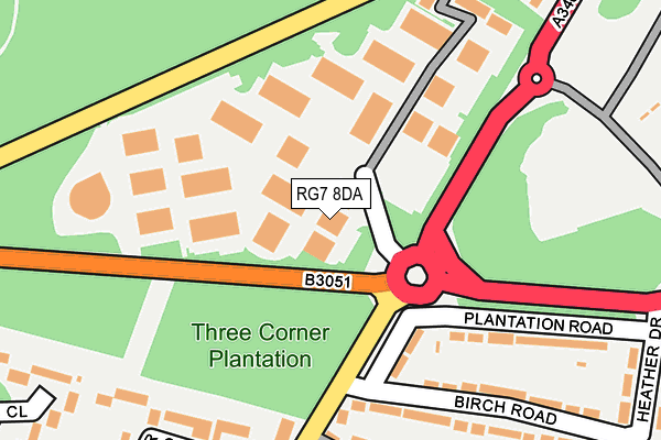
RG7 8DA is located in the Aldermaston electoral ward, within the unitary authority of West Berkshire and the English Parliamentary constituency of Newbury. The Sub Integrated Care Board (ICB) Location is NHS Buckinghamshire, Oxfordshire and Berkshire West ICB - 15A and the police force is Thames Valley. This postcode has been in use since July 1995.


GetTheData
Source: OS OpenMap – Local (Ordnance Survey)
Source: OS VectorMap District (Ordnance Survey)
Licence: Open Government Licence (requires attribution)
| Easting | 458387 |
| Northing | 162764 |
| Latitude | 51.360952 |
| Longitude | -1.162778 |
GetTheData
Source: Open Postcode Geo
Licence: Open Government Licence
| Country | England |
| Postcode District | RG7 |
➜ See where RG7 is on a map ➜ Where is Tadley? | |
GetTheData
Source: Land Registry Price Paid Data
Licence: Open Government Licence
Elevation or altitude of RG7 8DA as distance above sea level:
| Metres | Feet | |
|---|---|---|
| Elevation | 100m | 328ft |
Elevation is measured from the approximate centre of the postcode, to the nearest point on an OS contour line from OS Terrain 50, which has contour spacing of ten vertical metres.
➜ How high above sea level am I? Find the elevation of your current position using your device's GPS.
GetTheData
Source: Open Postcode Elevation
Licence: Open Government Licence
| Ward | Aldermaston |
| Constituency | Newbury |
GetTheData
Source: ONS Postcode Database
Licence: Open Government Licence
| Calleva Park (A340 Paices Hill) | Aldermaston | 91m |
| Calleva Park (A340 Paices Hill) | Aldermaston | 200m |
| Portway (Woodlands Road) | Baughurst Common | 389m |
| The Cricketers (Heath End Road) | Inhurst | 460m |
| The Cricketers (Heath End Road) | Inhurst | 475m |
| Midgham Station | 4km |
| Aldermaston Station | 4.9km |
GetTheData
Source: NaPTAN
Licence: Open Government Licence
GetTheData
Source: ONS Postcode Database
Licence: Open Government Licence


➜ Get more ratings from the Food Standards Agency
GetTheData
Source: Food Standards Agency
Licence: FSA terms & conditions
| Last Collection | |||
|---|---|---|---|
| Location | Mon-Fri | Sat | Distance |
| Calleva Park Meter Box | 76m | ||
| Calleva Park Estate | 18:30 | 08:00 | 77m |
| Heath End | 16:15 | 07:00 | 357m |
GetTheData
Source: Dracos
Licence: Creative Commons Attribution-ShareAlike
The below table lists the International Territorial Level (ITL) codes (formerly Nomenclature of Territorial Units for Statistics (NUTS) codes) and Local Administrative Units (LAU) codes for RG7 8DA:
| ITL 1 Code | Name |
|---|---|
| TLJ | South East (England) |
| ITL 2 Code | Name |
| TLJ1 | Berkshire, Buckinghamshire and Oxfordshire |
| ITL 3 Code | Name |
| TLJ11 | Berkshire |
| LAU 1 Code | Name |
| E06000037 | West Berkshire |
GetTheData
Source: ONS Postcode Directory
Licence: Open Government Licence
The below table lists the Census Output Area (OA), Lower Layer Super Output Area (LSOA), and Middle Layer Super Output Area (MSOA) for RG7 8DA:
| Code | Name | |
|---|---|---|
| OA | E00082125 | |
| LSOA | E01016254 | West Berkshire 011A |
| MSOA | E02003377 | West Berkshire 011 |
GetTheData
Source: ONS Postcode Directory
Licence: Open Government Licence
| RG7 8EN | Calleva Park | 48m |
| RG7 8EA | Calleva Park | 53m |
| RG7 8AA | Calleva Park | 73m |
| RG7 8HA | Calleva Park | 99m |
| RG7 8NN | Calleva Park | 121m |
| RG7 8NA | Calleva Park | 127m |
| RG7 8HN | Calleva Park | 155m |
| RG7 8SA | Calleva Park | 161m |
| RG7 8JN | Calleva Park | 166m |
| RG7 8LA | Calleva Park | 184m |
GetTheData
Source: Open Postcode Geo; Land Registry Price Paid Data
Licence: Open Government Licence