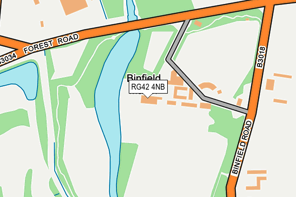
RG42 4NB is located in the Binfield North & Warfield West electoral ward, within the unitary authority of Bracknell Forest and the English Parliamentary constituency of Windsor. The Sub Integrated Care Board (ICB) Location is NHS Frimley ICB - D4U1Y and the police force is Thames Valley. This postcode has been in use since July 1995.


GetTheData
Source: OS OpenMap – Local (Ordnance Survey)
Source: OS VectorMap District (Ordnance Survey)
Licence: Open Government Licence (requires attribution)
| Easting | 485387 |
| Northing | 171087 |
| Latitude | 51.432361 |
| Longitude | -0.773088 |
GetTheData
Source: Open Postcode Geo
Licence: Open Government Licence
| Country | England |
| Postcode District | RG42 |
➜ See where RG42 is on a map ➜ Where is Binfield? | |
GetTheData
Source: Land Registry Price Paid Data
Licence: Open Government Licence
Elevation or altitude of RG42 4NB as distance above sea level:
| Metres | Feet | |
|---|---|---|
| Elevation | 50m | 164ft |
Elevation is measured from the approximate centre of the postcode, to the nearest point on an OS contour line from OS Terrain 50, which has contour spacing of ten vertical metres.
➜ How high above sea level am I? Find the elevation of your current position using your device's GPS.
GetTheData
Source: Open Postcode Elevation
Licence: Open Government Licence
| Ward | Binfield North & Warfield West |
| Constituency | Windsor |
GetTheData
Source: ONS Postcode Database
Licence: Open Government Licence
| The Grange (Binfield Road) | Binfield | 203m |
| The Grange (Binfield Road) | Binfield | 212m |
| Stag & Hounds Ph (Forest Road) | Binfield | 295m |
| Stag & Hounds Ph (Forest Road) | Binfield | 331m |
| Boltons Lane (Temple Way) | Temple Park | 490m |
| Bracknell Station | 2.6km |
| Martins Heron Station | 4.4km |
| Wokingham Station | 5.4km |
GetTheData
Source: NaPTAN
Licence: Open Government Licence
| Percentage of properties with Next Generation Access | 100.0% |
| Percentage of properties with Superfast Broadband | 0.0% |
| Percentage of properties with Ultrafast Broadband | 0.0% |
| Percentage of properties with Full Fibre Broadband | 0.0% |
Superfast Broadband is between 30Mbps and 300Mbps
Ultrafast Broadband is > 300Mbps
| Percentage of properties unable to receive 2Mbps | 0.0% |
| Percentage of properties unable to receive 5Mbps | 0.0% |
| Percentage of properties unable to receive 10Mbps | 0.0% |
| Percentage of properties unable to receive 30Mbps | 100.0% |
GetTheData
Source: Ofcom
Licence: Ofcom Terms of Use (requires attribution)
GetTheData
Source: ONS Postcode Database
Licence: Open Government Licence


➜ Get more ratings from the Food Standards Agency
GetTheData
Source: Food Standards Agency
Licence: FSA terms & conditions
| Last Collection | |||
|---|---|---|---|
| Location | Mon-Fri | Sat | Distance |
| Tilehurst Lane | 16:15 | 11:00 | 380m |
| Temple Way | 17:30 | 11:45 | 591m |
| Priestwood Avenue | 16:00 | 12:00 | 938m |
GetTheData
Source: Dracos
Licence: Creative Commons Attribution-ShareAlike
The below table lists the International Territorial Level (ITL) codes (formerly Nomenclature of Territorial Units for Statistics (NUTS) codes) and Local Administrative Units (LAU) codes for RG42 4NB:
| ITL 1 Code | Name |
|---|---|
| TLJ | South East (England) |
| ITL 2 Code | Name |
| TLJ1 | Berkshire, Buckinghamshire and Oxfordshire |
| ITL 3 Code | Name |
| TLJ11 | Berkshire |
| LAU 1 Code | Name |
| E06000036 | Bracknell Forest |
GetTheData
Source: ONS Postcode Directory
Licence: Open Government Licence
The below table lists the Census Output Area (OA), Lower Layer Super Output Area (LSOA), and Middle Layer Super Output Area (MSOA) for RG42 4NB:
| Code | Name | |
|---|---|---|
| OA | E00081813 | |
| LSOA | E01016188 | Bracknell Forest 002E |
| MSOA | E02003353 | Bracknell Forest 002 |
GetTheData
Source: ONS Postcode Directory
Licence: Open Government Licence
| RG42 4LY | Binfield Road | 331m |
| RG42 4UN | Blamire Drive | 538m |
| RG42 4BP | Pitch Place | 552m |
| RG42 4HA | Forest Road | 563m |
| RG42 5JS | Tilehurst Lane | 589m |
| RG42 4BZ | Forest Road | 613m |
| RG42 4UW | Wilstrode Avenue | 618m |
| RG42 4AF | Forest Road | 641m |
| RG42 5NG | Cabbage Hill Lane | 643m |
| RG42 5JU | Brooke Place | 674m |
GetTheData
Source: Open Postcode Geo; Land Registry Price Paid Data
Licence: Open Government Licence