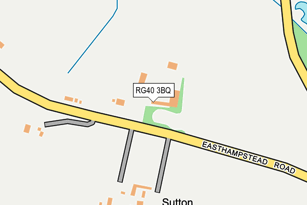
RG40 3BQ is located in the Wokingham Without electoral ward, within the unitary authority of Wokingham and the English Parliamentary constituency of Bracknell. The Sub Integrated Care Board (ICB) Location is NHS Buckinghamshire, Oxfordshire and Berkshire West ICB - 15A and the police force is Thames Valley. This postcode has been in use since June 1999.


GetTheData
Source: OS OpenMap – Local (Ordnance Survey)
Source: OS VectorMap District (Ordnance Survey)
Licence: Open Government Licence (requires attribution)
| Easting | 483489 |
| Northing | 166798 |
| Latitude | 51.394087 |
| Longitude | -0.801393 |
GetTheData
Source: Open Postcode Geo
Licence: Open Government Licence
| Country | England |
| Postcode District | RG40 |
➜ See where RG40 is on a map | |
GetTheData
Source: Land Registry Price Paid Data
Licence: Open Government Licence
Elevation or altitude of RG40 3BQ as distance above sea level:
| Metres | Feet | |
|---|---|---|
| Elevation | 60m | 197ft |
Elevation is measured from the approximate centre of the postcode, to the nearest point on an OS contour line from OS Terrain 50, which has contour spacing of ten vertical metres.
➜ How high above sea level am I? Find the elevation of your current position using your device's GPS.
GetTheData
Source: Open Postcode Elevation
Licence: Open Government Licence
| Ward | Wokingham Without |
| Constituency | Bracknell |
GetTheData
Source: ONS Postcode Database
Licence: Open Government Licence
| Easthampstead Mobile Home Park (Old Wokingham Road) | Pinewood | 1,046m |
| Easthampstead Mobile Home Park (Old Wokingham Road) | Pinewood | 1,101m |
| Pinewood Crossroads (Nine Mile Ride) | Crowthorne | 1,217m |
| Pinewood Crossroads (Old Wokingham Road) | Crowthorne | 1,248m |
| St Sebastians Roundabout (New Wokingham Road) | Bigshotte Park | 1,438m |
| Crowthorne Station | 3.3km |
| Wokingham Station | 3.4km |
| Bracknell Station | 4.1km |
GetTheData
Source: NaPTAN
Licence: Open Government Licence
| Percentage of properties with Next Generation Access | 100.0% |
| Percentage of properties with Superfast Broadband | 0.0% |
| Percentage of properties with Ultrafast Broadband | 0.0% |
| Percentage of properties with Full Fibre Broadband | 0.0% |
Superfast Broadband is between 30Mbps and 300Mbps
Ultrafast Broadband is > 300Mbps
| Percentage of properties unable to receive 2Mbps | 0.0% |
| Percentage of properties unable to receive 5Mbps | 0.0% |
| Percentage of properties unable to receive 10Mbps | 0.0% |
| Percentage of properties unable to receive 30Mbps | 100.0% |
GetTheData
Source: Ofcom
Licence: Ofcom Terms of Use (requires attribution)
GetTheData
Source: ONS Postcode Database
Licence: Open Government Licence


➜ Get more ratings from the Food Standards Agency
GetTheData
Source: Food Standards Agency
Licence: FSA terms & conditions
| Last Collection | |||
|---|---|---|---|
| Location | Mon-Fri | Sat | Distance |
| Honey Hill | 16:00 | 08:00 | 1,103m |
| The Conifers | 16:00 | 11:00 | 1,512m |
| Buckhurst Grove | 16:00 | 11:45 | 1,601m |
GetTheData
Source: Dracos
Licence: Creative Commons Attribution-ShareAlike
The below table lists the International Territorial Level (ITL) codes (formerly Nomenclature of Territorial Units for Statistics (NUTS) codes) and Local Administrative Units (LAU) codes for RG40 3BQ:
| ITL 1 Code | Name |
|---|---|
| TLJ | South East (England) |
| ITL 2 Code | Name |
| TLJ1 | Berkshire, Buckinghamshire and Oxfordshire |
| ITL 3 Code | Name |
| TLJ11 | Berkshire |
| LAU 1 Code | Name |
| E06000041 | Wokingham |
GetTheData
Source: ONS Postcode Directory
Licence: Open Government Licence
The below table lists the Census Output Area (OA), Lower Layer Super Output Area (LSOA), and Middle Layer Super Output Area (MSOA) for RG40 3BQ:
| Code | Name | |
|---|---|---|
| OA | E00084314 | |
| LSOA | E01016705 | Wokingham 020A |
| MSOA | E02003458 | Wokingham 020 |
GetTheData
Source: ONS Postcode Directory
Licence: Open Government Licence
| RG40 3BS | Easthampstead Road | 180m |
| RG40 3BP | Easthampstead Road | 322m |
| RG40 3BX | Old Wokingham Road | 424m |
| RG40 3BW | Easthampstead Road | 669m |
| RG40 3BT | Old Wokingham Road | 675m |
| RG40 3BD | Honey Hill | 717m |
| RG40 3BF | Redlake Lane | 731m |
| RG40 3BN | Easthampstead Road | 983m |
| RG40 3AW | Heathlands Road | 1014m |
| RG40 3BB | Honey Hill | 1041m |
GetTheData
Source: Open Postcode Geo; Land Registry Price Paid Data
Licence: Open Government Licence