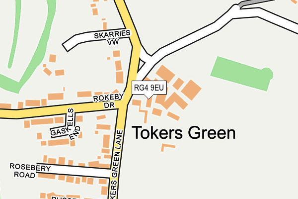
RG4 9EU is located in the Kidmore End & Whitchurch electoral ward, within the local authority district of South Oxfordshire and the English Parliamentary constituency of Henley. The Sub Integrated Care Board (ICB) Location is NHS Buckinghamshire, Oxfordshire and Berkshire West ICB - 10Q and the police force is Thames Valley. This postcode has been in use since January 1980.


GetTheData
Source: OS OpenMap – Local (Ordnance Survey)
Source: OS VectorMap District (Ordnance Survey)
Licence: Open Government Licence (requires attribution)
| Easting | 470114 |
| Northing | 177616 |
| Latitude | 51.493150 |
| Longitude | -0.991458 |
GetTheData
Source: Open Postcode Geo
Licence: Open Government Licence
| Country | England |
| Postcode District | RG4 |
➜ See where RG4 is on a map ➜ Where is Tokers Green? | |
GetTheData
Source: Land Registry Price Paid Data
Licence: Open Government Licence
Elevation or altitude of RG4 9EU as distance above sea level:
| Metres | Feet | |
|---|---|---|
| Elevation | 80m | 262ft |
Elevation is measured from the approximate centre of the postcode, to the nearest point on an OS contour line from OS Terrain 50, which has contour spacing of ten vertical metres.
➜ How high above sea level am I? Find the elevation of your current position using your device's GPS.
GetTheData
Source: Open Postcode Elevation
Licence: Open Government Licence
| Ward | Kidmore End & Whitchurch |
| Constituency | Henley |
GetTheData
Source: ONS Postcode Database
Licence: Open Government Licence
| Rokeby Drive (Reading Road) | Chazey Heath | 726m |
| Rokeby Drive (Reading Road) | Chazey Heath | 727m |
| Chalkhouse Green Lane (Tanners Lane) | Chalkhouse Green | 852m |
| Chalkhouse Green Lane (Tanners Lane) | Chalkhouse Green | 859m |
| The Packhorse Ph (A4074) | Woodcote | 962m |
| Tilehurst Station | 3.6km |
| Reading Station | 4.1km |
| Reading West Station | 4.2km |
GetTheData
Source: NaPTAN
Licence: Open Government Licence
GetTheData
Source: ONS Postcode Database
Licence: Open Government Licence


➜ Get more ratings from the Food Standards Agency
GetTheData
Source: Food Standards Agency
Licence: FSA terms & conditions
| Last Collection | |||
|---|---|---|---|
| Location | Mon-Fri | Sat | Distance |
| Tokers Green | 16:30 | 07:30 | 54m |
| Chalke House Green | 16:30 | 07:00 | 949m |
| Woodcote Way Post Office | 17:00 | 12:00 | 1,534m |
GetTheData
Source: Dracos
Licence: Creative Commons Attribution-ShareAlike
The below table lists the International Territorial Level (ITL) codes (formerly Nomenclature of Territorial Units for Statistics (NUTS) codes) and Local Administrative Units (LAU) codes for RG4 9EU:
| ITL 1 Code | Name |
|---|---|
| TLJ | South East (England) |
| ITL 2 Code | Name |
| TLJ1 | Berkshire, Buckinghamshire and Oxfordshire |
| ITL 3 Code | Name |
| TLJ14 | Oxfordshire CC |
| LAU 1 Code | Name |
| E07000179 | South Oxfordshire |
GetTheData
Source: ONS Postcode Directory
Licence: Open Government Licence
The below table lists the Census Output Area (OA), Lower Layer Super Output Area (LSOA), and Middle Layer Super Output Area (MSOA) for RG4 9EU:
| Code | Name | |
|---|---|---|
| OA | E00145983 | |
| LSOA | E01028659 | South Oxfordshire 020A |
| MSOA | E02005977 | South Oxfordshire 020 |
GetTheData
Source: ONS Postcode Directory
Licence: Open Government Licence
| RG4 9EX | Dysons Wood | 41m |
| RG4 9EB | Tokers Green Lane | 108m |
| RG4 9EN | Rokeby Drive | 181m |
| RG4 9EW | Gaskells End | 197m |
| RG4 9EA | Skarries View | 213m |
| RG4 9EL | Rosebery Road | 225m |
| RG4 9ED | Tokers Green Lane | 262m |
| RG4 9EJ | Russell Road | 293m |
| RG4 9EY | Dysons Wood | 350m |
| RG4 9EH | Beech Road | 353m |
GetTheData
Source: Open Postcode Geo; Land Registry Price Paid Data
Licence: Open Government Licence