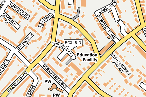
RG31 5JD lies on Chieveley Close in Tilehurst, Reading. RG31 5JD is located in the Tilehurst electoral ward, within the unitary authority of Reading and the English Parliamentary constituency of Reading West. The Sub Integrated Care Board (ICB) Location is NHS Buckinghamshire, Oxfordshire and Berkshire West ICB - 15A and the police force is Thames Valley. This postcode has been in use since July 1995.


GetTheData
Source: OS OpenMap – Local (Ordnance Survey)
Source: OS VectorMap District (Ordnance Survey)
Licence: Open Government Licence (requires attribution)
| Easting | 466412 |
| Northing | 173568 |
| Latitude | 51.457204 |
| Longitude | -1.045534 |
GetTheData
Source: Open Postcode Geo
Licence: Open Government Licence
| Street | Chieveley Close |
| Locality | Tilehurst |
| Town/City | Reading |
| Country | England |
| Postcode District | RG31 |
➜ See where RG31 is on a map ➜ Where is Reading? | |
GetTheData
Source: Land Registry Price Paid Data
Licence: Open Government Licence
Elevation or altitude of RG31 5JD as distance above sea level:
| Metres | Feet | |
|---|---|---|
| Elevation | 90m | 295ft |
Elevation is measured from the approximate centre of the postcode, to the nearest point on an OS contour line from OS Terrain 50, which has contour spacing of ten vertical metres.
➜ How high above sea level am I? Find the elevation of your current position using your device's GPS.
GetTheData
Source: Open Postcode Elevation
Licence: Open Government Licence
| Ward | Tilehurst |
| Constituency | Reading West |
GetTheData
Source: ONS Postcode Database
Licence: Open Government Licence
| Chapel Hill | Tilehurst | 84m |
| Chapel Hill | Tilehurst | 94m |
| Chapel Hill Lower Elmstone Drive (Chapel Hill) | Tilehurst | 124m |
| Chapel Hill Lower Elmstone Drive (Chapel Hill) | Tilehurst | 124m |
| Chapel Hill (Park Lane) | Tilehurst | 127m |
| Tilehurst Station | 1.9km |
| Theale Station | 3.3km |
| Reading West Station | 3.9km |
GetTheData
Source: NaPTAN
Licence: Open Government Licence
| Percentage of properties with Next Generation Access | 100.0% |
| Percentage of properties with Superfast Broadband | 100.0% |
| Percentage of properties with Ultrafast Broadband | 100.0% |
| Percentage of properties with Full Fibre Broadband | 0.0% |
Superfast Broadband is between 30Mbps and 300Mbps
Ultrafast Broadband is > 300Mbps
| Median download speed | 64.6Mbps |
| Average download speed | 66.1Mbps |
| Maximum download speed | 100.00Mbps |
| Median upload speed | 10.0Mbps |
| Average upload speed | 12.4Mbps |
| Maximum upload speed | 20.00Mbps |
| Percentage of properties unable to receive 2Mbps | 0.0% |
| Percentage of properties unable to receive 5Mbps | 0.0% |
| Percentage of properties unable to receive 10Mbps | 0.0% |
| Percentage of properties unable to receive 30Mbps | 0.0% |
GetTheData
Source: Ofcom
Licence: Ofcom Terms of Use (requires attribution)
Estimated total energy consumption in RG31 5JD by fuel type, 2015.
| Consumption (kWh) | 181,225 |
|---|---|
| Meter count | 12 |
| Mean (kWh/meter) | 15,102 |
| Median (kWh/meter) | 13,936 |
| Consumption (kWh) | 114,809 |
|---|---|
| Meter count | 27 |
| Mean (kWh/meter) | 4,252 |
| Median (kWh/meter) | 4,330 |
GetTheData
Source: Postcode level gas estimates: 2015 (experimental)
Source: Postcode level electricity estimates: 2015 (experimental)
Licence: Open Government Licence
GetTheData
Source: ONS Postcode Database
Licence: Open Government Licence


➜ Get more ratings from the Food Standards Agency
GetTheData
Source: Food Standards Agency
Licence: FSA terms & conditions
| Last Collection | |||
|---|---|---|---|
| Location | Mon-Fri | Sat | Distance |
| Triangle | 16:30 | 11:00 | 266m |
| Pegasus Court | 16:00 | 13:45 | 315m |
| Park Lane | 16:00 | 13:30 | 491m |
GetTheData
Source: Dracos
Licence: Creative Commons Attribution-ShareAlike
The below table lists the International Territorial Level (ITL) codes (formerly Nomenclature of Territorial Units for Statistics (NUTS) codes) and Local Administrative Units (LAU) codes for RG31 5JD:
| ITL 1 Code | Name |
|---|---|
| TLJ | South East (England) |
| ITL 2 Code | Name |
| TLJ1 | Berkshire, Buckinghamshire and Oxfordshire |
| ITL 3 Code | Name |
| TLJ11 | Berkshire |
| LAU 1 Code | Name |
| E06000038 | Reading |
GetTheData
Source: ONS Postcode Directory
Licence: Open Government Licence
The below table lists the Census Output Area (OA), Lower Layer Super Output Area (LSOA), and Middle Layer Super Output Area (MSOA) for RG31 5JD:
| Code | Name | |
|---|---|---|
| OA | E00082998 | |
| LSOA | E01016432 | Reading 005E |
| MSOA | E02003393 | Reading 005 |
GetTheData
Source: ONS Postcode Directory
Licence: Open Government Licence
| RG31 5JG | Enborne Close | 30m |
| RG31 5JE | Wootton Close | 62m |
| RG31 5BT | Chapel Hill | 63m |
| RG31 5JH | Hildens Drive | 73m |
| RG31 5JF | Sheppard Court | 79m |
| RG31 5JB | Hildens Drive | 93m |
| RG31 5DL | Park Lane | 97m |
| RG31 5JA | Hildens Drive | 112m |
| RG31 5DG | Chapel Hill | 116m |
| RG31 5JJ | Berkshire Drive | 117m |
GetTheData
Source: Open Postcode Geo; Land Registry Price Paid Data
Licence: Open Government Licence