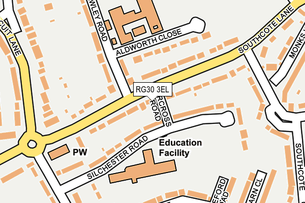
RG30 3EL lies on Faircross Road in Reading. RG30 3EL is located in the Southcote electoral ward, within the unitary authority of Reading and the English Parliamentary constituency of Reading West. The Sub Integrated Care Board (ICB) Location is NHS Buckinghamshire, Oxfordshire and Berkshire West ICB - 15A and the police force is Thames Valley. This postcode has been in use since July 1995.


GetTheData
Source: OS OpenMap – Local (Ordnance Survey)
Source: OS VectorMap District (Ordnance Survey)
Licence: Open Government Licence (requires attribution)
| Easting | 469335 |
| Northing | 172056 |
| Latitude | 51.443262 |
| Longitude | -1.003745 |
GetTheData
Source: Open Postcode Geo
Licence: Open Government Licence
| Street | Faircross Road |
| Town/City | Reading |
| Country | England |
| Postcode District | RG30 |
➜ See where RG30 is on a map ➜ Where is Reading? | |
GetTheData
Source: Land Registry Price Paid Data
Licence: Open Government Licence
Elevation or altitude of RG30 3EL as distance above sea level:
| Metres | Feet | |
|---|---|---|
| Elevation | 50m | 164ft |
Elevation is measured from the approximate centre of the postcode, to the nearest point on an OS contour line from OS Terrain 50, which has contour spacing of ten vertical metres.
➜ How high above sea level am I? Find the elevation of your current position using your device's GPS.
GetTheData
Source: Open Postcode Elevation
Licence: Open Government Licence
| Ward | Southcote |
| Constituency | Reading West |
GetTheData
Source: ONS Postcode Database
Licence: Open Government Licence
| Fawley Road (Southcote Lane) | Southcote | 38m |
| Fawley Road (Southcote Lane) | Southcote | 80m |
| Southcote Farm Lane (Southcote Lane) | Southcote | 190m |
| Circuit Lane (Southcote Lane) | Southcote | 203m |
| Circuit Lane | Southcote | 249m |
| Reading West Station | 1.7km |
| Reading Station | 2.8km |
| Tilehurst Station | 3.6km |
GetTheData
Source: NaPTAN
Licence: Open Government Licence
| Percentage of properties with Next Generation Access | 100.0% |
| Percentage of properties with Superfast Broadband | 100.0% |
| Percentage of properties with Ultrafast Broadband | 66.7% |
| Percentage of properties with Full Fibre Broadband | 0.0% |
Superfast Broadband is between 30Mbps and 300Mbps
Ultrafast Broadband is > 300Mbps
| Percentage of properties unable to receive 2Mbps | 0.0% |
| Percentage of properties unable to receive 5Mbps | 0.0% |
| Percentage of properties unable to receive 10Mbps | 0.0% |
| Percentage of properties unable to receive 30Mbps | 0.0% |
GetTheData
Source: Ofcom
Licence: Ofcom Terms of Use (requires attribution)
GetTheData
Source: ONS Postcode Database
Licence: Open Government Licence


➜ Get more ratings from the Food Standards Agency
GetTheData
Source: Food Standards Agency
Licence: FSA terms & conditions
| Last Collection | |||
|---|---|---|---|
| Location | Mon-Fri | Sat | Distance |
| Coronation Square Post Office | 17:00 | 13:30 | 491m |
| Parkside Road | 16:00 | 14:30 | 600m |
| Kenilworth Avenue | 17:30 | 13:30 | 695m |
GetTheData
Source: Dracos
Licence: Creative Commons Attribution-ShareAlike
The below table lists the International Territorial Level (ITL) codes (formerly Nomenclature of Territorial Units for Statistics (NUTS) codes) and Local Administrative Units (LAU) codes for RG30 3EL:
| ITL 1 Code | Name |
|---|---|
| TLJ | South East (England) |
| ITL 2 Code | Name |
| TLJ1 | Berkshire, Buckinghamshire and Oxfordshire |
| ITL 3 Code | Name |
| TLJ11 | Berkshire |
| LAU 1 Code | Name |
| E06000038 | Reading |
GetTheData
Source: ONS Postcode Directory
Licence: Open Government Licence
The below table lists the Census Output Area (OA), Lower Layer Super Output Area (LSOA), and Middle Layer Super Output Area (MSOA) for RG30 3EL:
| Code | Name | |
|---|---|---|
| OA | E00082947 | |
| LSOA | E01016419 | Reading 015A |
| MSOA | E02003403 | Reading 015 |
GetTheData
Source: ONS Postcode Directory
Licence: Open Government Licence
| RG30 3EJ | Silchester Road | 41m |
| RG30 3AJ | Southcote Lane | 71m |
| RG30 3AF | Southcote Lane | 98m |
| RG30 3AH | Southcote Lane | 106m |
| RG30 3ER | Aldworth Close | 109m |
| RG30 3AL | Southcote Lane | 131m |
| RG30 3EN | Fawley Road | 171m |
| RG30 3HE | Kintbury Walk | 192m |
| RG30 3HG | Shepley Drive | 200m |
| RG30 3DS | Southcote Farm Lane | 209m |
GetTheData
Source: Open Postcode Geo; Land Registry Price Paid Data
Licence: Open Government Licence