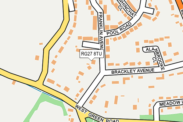
RG27 8TU lies on Franklin Avenue in Hartley Wintney, Hook. RG27 8TU is located in the Hartley Wintney electoral ward, within the local authority district of Hart and the English Parliamentary constituency of North East Hampshire. The Sub Integrated Care Board (ICB) Location is NHS Hampshire and Isle of Wight ICB - D9Y0V and the police force is Hampshire. This postcode has been in use since January 1980.


GetTheData
Source: OS OpenMap – Local (Ordnance Survey)
Source: OS VectorMap District (Ordnance Survey)
Licence: Open Government Licence (requires attribution)
| Easting | 475996 |
| Northing | 156945 |
| Latitude | 51.306560 |
| Longitude | -0.911170 |
GetTheData
Source: Open Postcode Geo
Licence: Open Government Licence
| Street | Franklin Avenue |
| Locality | Hartley Wintney |
| Town/City | Hook |
| Country | England |
| Postcode District | RG27 |
➜ See where RG27 is on a map ➜ Where is Hartley Wintney? | |
GetTheData
Source: Land Registry Price Paid Data
Licence: Open Government Licence
Elevation or altitude of RG27 8TU as distance above sea level:
| Metres | Feet | |
|---|---|---|
| Elevation | 70m | 230ft |
Elevation is measured from the approximate centre of the postcode, to the nearest point on an OS contour line from OS Terrain 50, which has contour spacing of ten vertical metres.
➜ How high above sea level am I? Find the elevation of your current position using your device's GPS.
GetTheData
Source: Open Postcode Elevation
Licence: Open Government Licence
| Ward | Hartley Wintney |
| Constituency | North East Hampshire |
GetTheData
Source: ONS Postcode Database
Licence: Open Government Licence
FRANKLIN HOUSE, 1, FRANKLIN AVENUE, HARTLEY WINTNEY, HOOK, RG27 8TU 1999 17 SEP £327,000 |
➜ Hartley Wintney house prices
GetTheData
Source: HM Land Registry Price Paid Data
Licence: Contains HM Land Registry data © Crown copyright and database right 2025. This data is licensed under the Open Government Licence v3.0.
| Hartford Road (Bracknell Lane) | Hartley Wintney | 351m |
| Hartford Road (Bracknell Lane) | Hartley Wintney | 351m |
| Franklin Avenue (Bracknell Lane B3011) | Hartley Wintney | 388m |
| Franklin Avenue (Bracknell Lane B3011) | Hartley Wintney | 401m |
| Meadow Lane (Bracknell Lane B3011) | Hartley Wintney | 437m |
| Winchfield Station | 2.4km |
| Hook Station | 4.6km |
GetTheData
Source: NaPTAN
Licence: Open Government Licence
GetTheData
Source: ONS Postcode Database
Licence: Open Government Licence


➜ Get more ratings from the Food Standards Agency
GetTheData
Source: Food Standards Agency
Licence: FSA terms & conditions
| Last Collection | |||
|---|---|---|---|
| Location | Mon-Fri | Sat | Distance |
| Brackley Avenue | 17:00 | 07:00 | 133m |
| Bracknell Lane | 17:00 | 07:00 | 360m |
| Pheonix Road (Police House) | 17:00 | 07:00 | 489m |
GetTheData
Source: Dracos
Licence: Creative Commons Attribution-ShareAlike
The below table lists the International Territorial Level (ITL) codes (formerly Nomenclature of Territorial Units for Statistics (NUTS) codes) and Local Administrative Units (LAU) codes for RG27 8TU:
| ITL 1 Code | Name |
|---|---|
| TLJ | South East (England) |
| ITL 2 Code | Name |
| TLJ3 | Hampshire and Isle of Wight |
| ITL 3 Code | Name |
| TLJ37 | North Hampshire |
| LAU 1 Code | Name |
| E07000089 | Hart |
GetTheData
Source: ONS Postcode Directory
Licence: Open Government Licence
The below table lists the Census Output Area (OA), Lower Layer Super Output Area (LSOA), and Middle Layer Super Output Area (MSOA) for RG27 8TU:
| Code | Name | |
|---|---|---|
| OA | E00116256 | |
| LSOA | E01022878 | Hart 004B |
| MSOA | E02004754 | Hart 004 |
GetTheData
Source: ONS Postcode Directory
Licence: Open Government Licence
| RG27 8RA | Churchill Close | 41m |
| RG27 8QZ | Franklin Avenue | 66m |
| RG27 8QX | Brackley Avenue | 103m |
| RG27 8LP | West Green Road | 137m |
| RG27 8LR | Arrow Lane | 169m |
| RG27 8RE | West Green Road | 208m |
| RG27 8QU | Brackley Avenue | 208m |
| RG27 8RB | Franklin Avenue | 214m |
| RG27 8QY | Alanbrooke Close | 221m |
| RG27 8TT | Whinchat Close | 225m |
GetTheData
Source: Open Postcode Geo; Land Registry Price Paid Data
Licence: Open Government Licence