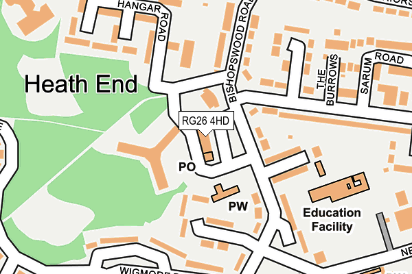
RG26 4HD lies on Bishopswood Road in Tadley. RG26 4HD is located in the Tadley North, Kingsclere & Baughurst electoral ward, within the local authority district of Basingstoke and Deane and the English Parliamentary constituency of North West Hampshire. The Sub Integrated Care Board (ICB) Location is NHS Hampshire and Isle of Wight ICB - D9Y0V and the police force is Hampshire. This postcode has been in use since July 1995.


GetTheData
Source: OS OpenMap – Local (Ordnance Survey)
Source: OS VectorMap District (Ordnance Survey)
Licence: Open Government Licence (requires attribution)
| Easting | 458868 |
| Northing | 162281 |
| Latitude | 51.356560 |
| Longitude | -1.155970 |
GetTheData
Source: Open Postcode Geo
Licence: Open Government Licence
| Street | Bishopswood Road |
| Town/City | Tadley |
| Country | England |
| Postcode District | RG26 |
➜ See where RG26 is on a map ➜ Where is Tadley? | |
GetTheData
Source: Land Registry Price Paid Data
Licence: Open Government Licence
Elevation or altitude of RG26 4HD as distance above sea level:
| Metres | Feet | |
|---|---|---|
| Elevation | 100m | 328ft |
Elevation is measured from the approximate centre of the postcode, to the nearest point on an OS contour line from OS Terrain 50, which has contour spacing of ten vertical metres.
➜ How high above sea level am I? Find the elevation of your current position using your device's GPS.
GetTheData
Source: Open Postcode Elevation
Licence: Open Government Licence
| Ward | Tadley North, Kingsclere & Baughurst |
| Constituency | North West Hampshire |
GetTheData
Source: ONS Postcode Database
Licence: Open Government Licence
| Bishopswood Road Shops (Bishopswood Road) | Baughurst | 47m |
| Bishopwood Court (Hangar Road) | Tadley | 63m |
| Bishopswood Road Shops (Bishopswood Road) | Baughurst | 77m |
| Wigmore Road (Bishopswood Road) | Baughurst | 261m |
| Furze Road (Burnham Road) | Baughurst | 306m |
| Midgham Station | 4.6km |
GetTheData
Source: NaPTAN
Licence: Open Government Licence
GetTheData
Source: ONS Postcode Database
Licence: Open Government Licence


➜ Get more ratings from the Food Standards Agency
GetTheData
Source: Food Standards Agency
Licence: FSA terms & conditions
| Last Collection | |||
|---|---|---|---|
| Location | Mon-Fri | Sat | Distance |
| North Tadley Post Office | 17:00 | 10:30 | 25m |
| Tadley Delivery Office | 17:00 | 10:00 | 286m |
| Priors Road | 16:15 | 07:00 | 474m |
GetTheData
Source: Dracos
Licence: Creative Commons Attribution-ShareAlike
The below table lists the International Territorial Level (ITL) codes (formerly Nomenclature of Territorial Units for Statistics (NUTS) codes) and Local Administrative Units (LAU) codes for RG26 4HD:
| ITL 1 Code | Name |
|---|---|
| TLJ | South East (England) |
| ITL 2 Code | Name |
| TLJ3 | Hampshire and Isle of Wight |
| ITL 3 Code | Name |
| TLJ37 | North Hampshire |
| LAU 1 Code | Name |
| E07000084 | Basingstoke and Deane |
GetTheData
Source: ONS Postcode Directory
Licence: Open Government Licence
The below table lists the Census Output Area (OA), Lower Layer Super Output Area (LSOA), and Middle Layer Super Output Area (MSOA) for RG26 4HD:
| Code | Name | |
|---|---|---|
| OA | E00114666 | |
| LSOA | E01022556 | Basingstoke and Deane 001D |
| MSOA | E02004675 | Basingstoke and Deane 001 |
GetTheData
Source: ONS Postcode Directory
Licence: Open Government Licence
| RG26 4HG | Bishopswood Road | 127m |
| RG26 4HF | Bishopswood Road | 131m |
| RG26 4HA | Bishopswood Road | 146m |
| RG26 4HB | Bishopswood Road | 151m |
| RG26 4QQ | Hangar Road | 203m |
| RG26 4EZ | Franklin Avenue | 216m |
| RG26 4EU | Franklin Avenue | 224m |
| RG26 4HH | Wigmore Road | 229m |
| RG26 4EP | The Burrows | 231m |
| RG26 4EA | Elisha Place | 242m |
GetTheData
Source: Open Postcode Geo; Land Registry Price Paid Data
Licence: Open Government Licence