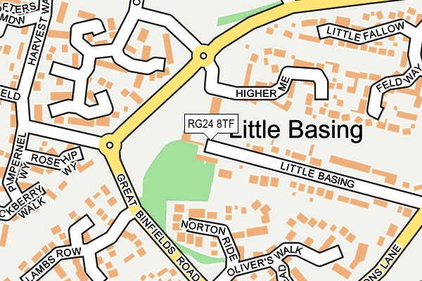
RG24 8TF is located in the Basing & Upton Grey electoral ward, within the local authority district of Basingstoke and Deane and the English Parliamentary constituency of Basingstoke. The Sub Integrated Care Board (ICB) Location is NHS Hampshire and Isle of Wight ICB - D9Y0V and the police force is Hampshire. This postcode has been in use since August 1993.


GetTheData
Source: OS OpenMap – Local (Ordnance Survey)
Source: OS VectorMap District (Ordnance Survey)
Licence: Open Government Licence (requires attribution)
| Easting | 465836 |
| Northing | 153436 |
| Latitude | 51.276276 |
| Longitude | -1.057526 |
GetTheData
Source: Open Postcode Geo
Licence: Open Government Licence
| Country | England |
| Postcode District | RG24 |
➜ See where RG24 is on a map ➜ Where is Basingstoke? | |
GetTheData
Source: Land Registry Price Paid Data
Licence: Open Government Licence
Elevation or altitude of RG24 8TF as distance above sea level:
| Metres | Feet | |
|---|---|---|
| Elevation | 80m | 262ft |
Elevation is measured from the approximate centre of the postcode, to the nearest point on an OS contour line from OS Terrain 50, which has contour spacing of ten vertical metres.
➜ How high above sea level am I? Find the elevation of your current position using your device's GPS.
GetTheData
Source: Open Postcode Elevation
Licence: Open Government Licence
| Ward | Basing & Upton Grey |
| Constituency | Basingstoke |
GetTheData
Source: ONS Postcode Database
Licence: Open Government Licence
| Cromwell Inn (Great Binfields Road) | Lychpit | 88m |
| Cromwell Inn (Great Binfields Road) | Lychpit | 171m |
| Great Binfields Crescent (Great Binfields Road) | Lychpit | 236m |
| Saxon Way (Great Binfields Road) | Lychpit | 251m |
| Saxon Way (Great Binfields Road) | Lychpit | 286m |
| Basingstoke Station | 2.3km |
GetTheData
Source: NaPTAN
Licence: Open Government Licence
GetTheData
Source: ONS Postcode Database
Licence: Open Government Licence


➜ Get more ratings from the Food Standards Agency
GetTheData
Source: Food Standards Agency
Licence: FSA terms & conditions
| Last Collection | |||
|---|---|---|---|
| Location | Mon-Fri | Sat | Distance |
| Lychpit Centre | 16:00 | 09:00 | 71m |
| Bartons Lane | 16:00 | 09:00 | 329m |
| Daneshill | 18:30 | 374m | |
GetTheData
Source: Dracos
Licence: Creative Commons Attribution-ShareAlike
The below table lists the International Territorial Level (ITL) codes (formerly Nomenclature of Territorial Units for Statistics (NUTS) codes) and Local Administrative Units (LAU) codes for RG24 8TF:
| ITL 1 Code | Name |
|---|---|
| TLJ | South East (England) |
| ITL 2 Code | Name |
| TLJ3 | Hampshire and Isle of Wight |
| ITL 3 Code | Name |
| TLJ37 | North Hampshire |
| LAU 1 Code | Name |
| E07000084 | Basingstoke and Deane |
GetTheData
Source: ONS Postcode Directory
Licence: Open Government Licence
The below table lists the Census Output Area (OA), Lower Layer Super Output Area (LSOA), and Middle Layer Super Output Area (MSOA) for RG24 8TF:
| Code | Name | |
|---|---|---|
| OA | E00114256 | |
| LSOA | E01022471 | Basingstoke and Deane 008B |
| MSOA | E02004682 | Basingstoke and Deane 008 |
GetTheData
Source: ONS Postcode Directory
Licence: Open Government Licence
| RG24 8SF | Norton Ride | 110m |
| RG24 8RP | Cowslip Bank | 157m |
| RG24 8YL | Higher Mead | 162m |
| RG24 8AX | Little Basing | 177m |
| RG24 8SE | Gage Close | 180m |
| RG24 8SW | Rosehip Way | 199m |
| RG24 8SQ | Peake Close | 220m |
| RG24 8SD | Olivers Walk | 221m |
| RG24 8RR | Cowslip Bank | 226m |
| RG24 8SG | Whitehead Close | 244m |
GetTheData
Source: Open Postcode Geo; Land Registry Price Paid Data
Licence: Open Government Licence