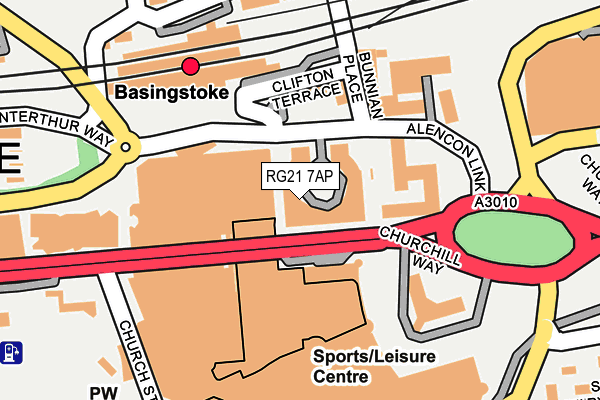
RG21 7AP is located in the Brookvale & Kings Furlong electoral ward, within the local authority district of Basingstoke and Deane and the English Parliamentary constituency of Basingstoke. The Sub Integrated Care Board (ICB) Location is NHS Hampshire and Isle of Wight ICB - D9Y0V and the police force is Hampshire. This postcode has been in use since September 2007.


GetTheData
Source: OS OpenMap – Local (Ordnance Survey)
Source: OS VectorMap District (Ordnance Survey)
Licence: Open Government Licence (requires attribution)
| Easting | 463838 |
| Northing | 152403 |
| Latitude | 51.267215 |
| Longitude | -1.086369 |
GetTheData
Source: Open Postcode Geo
Licence: Open Government Licence
| Country | England |
| Postcode District | RG21 |
➜ See where RG21 is on a map ➜ Where is Basingstoke? | |
GetTheData
Source: Land Registry Price Paid Data
Licence: Open Government Licence
Elevation or altitude of RG21 7AP as distance above sea level:
| Metres | Feet | |
|---|---|---|
| Elevation | 80m | 262ft |
Elevation is measured from the approximate centre of the postcode, to the nearest point on an OS contour line from OS Terrain 50, which has contour spacing of ten vertical metres.
➜ How high above sea level am I? Find the elevation of your current position using your device's GPS.
GetTheData
Source: Open Postcode Elevation
Licence: Open Government Licence
| Ward | Brookvale & Kings Furlong |
| Constituency | Basingstoke |
GetTheData
Source: ONS Postcode Database
Licence: Open Government Licence
| Churchill Way | Basingstoke | 43m |
| Coach Stop | Basingstoke | 68m |
| Railway Station (Alencon Link) | Basingstoke | 98m |
| Railway Station (Alencon Link) | Basingstoke | 102m |
| St Michaels (Church Street) | Eastrop | 262m |
| Basingstoke Station | 0.1km |
GetTheData
Source: NaPTAN
Licence: Open Government Licence
GetTheData
Source: ONS Postcode Database
Licence: Open Government Licence


➜ Get more ratings from the Food Standards Agency
GetTheData
Source: Food Standards Agency
Licence: FSA terms & conditions
| Last Collection | |||
|---|---|---|---|
| Location | Mon-Fri | Sat | Distance |
| Railway Station | 17:30 | 10:30 | 125m |
| Lower Church Street | 17:30 | 10:30 | 258m |
| South View Post Office | 17:00 | 10:15 | 393m |
GetTheData
Source: Dracos
Licence: Creative Commons Attribution-ShareAlike
The below table lists the International Territorial Level (ITL) codes (formerly Nomenclature of Territorial Units for Statistics (NUTS) codes) and Local Administrative Units (LAU) codes for RG21 7AP:
| ITL 1 Code | Name |
|---|---|
| TLJ | South East (England) |
| ITL 2 Code | Name |
| TLJ3 | Hampshire and Isle of Wight |
| ITL 3 Code | Name |
| TLJ37 | North Hampshire |
| LAU 1 Code | Name |
| E07000084 | Basingstoke and Deane |
GetTheData
Source: ONS Postcode Directory
Licence: Open Government Licence
The below table lists the Census Output Area (OA), Lower Layer Super Output Area (LSOA), and Middle Layer Super Output Area (MSOA) for RG21 7AP:
| Code | Name | |
|---|---|---|
| OA | E00167857 | |
| LSOA | E01032842 | Basingstoke and Deane 011E |
| MSOA | E02004685 | Basingstoke and Deane 011 |
GetTheData
Source: ONS Postcode Directory
Licence: Open Government Licence
| RG21 7TW | Alencon Link | 42m |
| RG21 7TY | Alencon Link | 46m |
| RG21 7TR | Alencon Link | 50m |
| RG21 7TS | Alencon Link | 51m |
| RG21 7TZ | Alencon Link | 59m |
| RG21 7TN | Alencon Link | 63m |
| RG21 7BJ | Alencon Link | 106m |
| RG21 7AY | Alencon Link | 107m |
| RG21 7AZ | Skyline Plaza | 108m |
| RG21 7AU | Alencon Link | 111m |
GetTheData
Source: Open Postcode Geo; Land Registry Price Paid Data
Licence: Open Government Licence