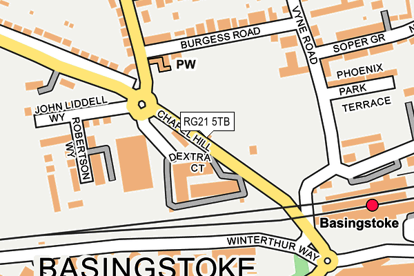
RG21 5TB lies on Chapel Hill in Basingstoke. RG21 5TB is located in the Norden electoral ward, within the local authority district of Basingstoke and Deane and the English Parliamentary constituency of Basingstoke. The Sub Integrated Care Board (ICB) Location is NHS Hampshire and Isle of Wight ICB - D9Y0V and the police force is Hampshire. This postcode has been in use since July 1995.


GetTheData
Source: OS OpenMap – Local (Ordnance Survey)
Source: OS VectorMap District (Ordnance Survey)
Licence: Open Government Licence (requires attribution)
| Easting | 463444 |
| Northing | 152639 |
| Latitude | 51.269381 |
| Longitude | -1.091955 |
GetTheData
Source: Open Postcode Geo
Licence: Open Government Licence
| Street | Chapel Hill |
| Town/City | Basingstoke |
| Country | England |
| Postcode District | RG21 |
➜ See where RG21 is on a map ➜ Where is Basingstoke? | |
GetTheData
Source: Land Registry Price Paid Data
Licence: Open Government Licence
Elevation or altitude of RG21 5TB as distance above sea level:
| Metres | Feet | |
|---|---|---|
| Elevation | 100m | 328ft |
Elevation is measured from the approximate centre of the postcode, to the nearest point on an OS contour line from OS Terrain 50, which has contour spacing of ten vertical metres.
➜ How high above sea level am I? Find the elevation of your current position using your device's GPS.
GetTheData
Source: Open Postcode Elevation
Licence: Open Government Licence
| Ward | Norden |
| Constituency | Basingstoke |
GetTheData
Source: ONS Postcode Database
Licence: Open Government Licence
2024 1 AUG £490,000 |
2009 26 OCT £225,000 |
2003 28 NOV £180,000 |
2001 9 MAR £130,000 |
1998 9 SEP £125,000 |
1995 19 MAY £64,000 |
GetTheData
Source: HM Land Registry Price Paid Data
Licence: Contains HM Land Registry data © Crown copyright and database right 2025. This data is licensed under the Open Government Licence v3.0.
| The Rising Sun (Chapel Hill) | South View | 18m |
| The Rising Sun (Chapel Hill) | South View | 24m |
| Sherborne Road (Cromwell Road) | South View | 208m |
| Vyne Road (Cromwell Road) | South View | 235m |
| Victory Roundabout (Alencon Link) | Basingstoke | 240m |
| Basingstoke Station | 0.3km |
GetTheData
Source: NaPTAN
Licence: Open Government Licence
| Percentage of properties with Next Generation Access | 100.0% |
| Percentage of properties with Superfast Broadband | 100.0% |
| Percentage of properties with Ultrafast Broadband | 0.0% |
| Percentage of properties with Full Fibre Broadband | 0.0% |
Superfast Broadband is between 30Mbps and 300Mbps
Ultrafast Broadband is > 300Mbps
| Percentage of properties unable to receive 2Mbps | 0.0% |
| Percentage of properties unable to receive 5Mbps | 0.0% |
| Percentage of properties unable to receive 10Mbps | 0.0% |
| Percentage of properties unable to receive 30Mbps | 0.0% |
GetTheData
Source: Ofcom
Licence: Ofcom Terms of Use (requires attribution)
GetTheData
Source: ONS Postcode Database
Licence: Open Government Licence


➜ Get more ratings from the Food Standards Agency
GetTheData
Source: Food Standards Agency
Licence: FSA terms & conditions
| Last Collection | |||
|---|---|---|---|
| Location | Mon-Fri | Sat | Distance |
| London Street Meter Box | 18:30 | 183m | |
| Cromwell Road | 17:00 | 10:30 | 220m |
| South View Post Office | 17:00 | 10:15 | 235m |
GetTheData
Source: Dracos
Licence: Creative Commons Attribution-ShareAlike
The below table lists the International Territorial Level (ITL) codes (formerly Nomenclature of Territorial Units for Statistics (NUTS) codes) and Local Administrative Units (LAU) codes for RG21 5TB:
| ITL 1 Code | Name |
|---|---|
| TLJ | South East (England) |
| ITL 2 Code | Name |
| TLJ3 | Hampshire and Isle of Wight |
| ITL 3 Code | Name |
| TLJ37 | North Hampshire |
| LAU 1 Code | Name |
| E07000084 | Basingstoke and Deane |
GetTheData
Source: ONS Postcode Directory
Licence: Open Government Licence
The below table lists the Census Output Area (OA), Lower Layer Super Output Area (LSOA), and Middle Layer Super Output Area (MSOA) for RG21 5TB:
| Code | Name | |
|---|---|---|
| OA | E00114535 | |
| LSOA | E01022526 | Basingstoke and Deane 009C |
| MSOA | E02004683 | Basingstoke and Deane 009 |
GetTheData
Source: ONS Postcode Directory
Licence: Open Government Licence
| RG21 5UH | Chapel Hill | 82m |
| RG21 5NP | Burgess Road | 157m |
| RG21 5TH | Sherborne Road | 164m |
| RG21 5TE | Sherborne Road | 175m |
| RG21 5NZ | Sylvaner Court | 195m |
| RG21 7UH | Winterthur Way | 213m |
| RG21 6SZ | Winterthur Way | 220m |
| RG21 5NS | Cromwell Road | 229m |
| RG21 5NT | Cromwell Road | 230m |
| RG21 5UQ | Kingsclere Road | 232m |
GetTheData
Source: Open Postcode Geo; Land Registry Price Paid Data
Licence: Open Government Licence