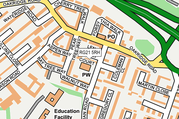
RG21 5RH lies on Len Smart Court in Basingstoke. RG21 5RH is located in the Norden electoral ward, within the local authority district of Basingstoke and Deane and the English Parliamentary constituency of Basingstoke. The Sub Integrated Care Board (ICB) Location is NHS Hampshire and Isle of Wight ICB - D9Y0V and the police force is Hampshire. This postcode has been in use since July 1995.


GetTheData
Source: OS OpenMap – Local (Ordnance Survey)
Source: OS VectorMap District (Ordnance Survey)
Licence: Open Government Licence (requires attribution)
| Easting | 464276 |
| Northing | 153462 |
| Latitude | 51.276687 |
| Longitude | -1.079902 |
GetTheData
Source: Open Postcode Geo
Licence: Open Government Licence
| Street | Len Smart Court |
| Town/City | Basingstoke |
| Country | England |
| Postcode District | RG21 |
➜ See where RG21 is on a map ➜ Where is Basingstoke? | |
GetTheData
Source: Land Registry Price Paid Data
Licence: Open Government Licence
Elevation or altitude of RG21 5RH as distance above sea level:
| Metres | Feet | |
|---|---|---|
| Elevation | 100m | 328ft |
Elevation is measured from the approximate centre of the postcode, to the nearest point on an OS contour line from OS Terrain 50, which has contour spacing of ten vertical metres.
➜ How high above sea level am I? Find the elevation of your current position using your device's GPS.
GetTheData
Source: Open Postcode Elevation
Licence: Open Government Licence
| Ward | Norden |
| Constituency | Basingstoke |
GetTheData
Source: ONS Postcode Database
Licence: Open Government Licence
| Walnut Way (Vivian Road) | Oakridge | 57m |
| Oakridge Centre (Oakridge Road) | Oakridge | 82m |
| Oakridge Centre | Oakridge | 91m |
| Walnut Way (Vivian Road) | Oakridge | 105m |
| Oakridge House (Jefferson Road) | Oakridge | 187m |
| Basingstoke Station | 1.1km |
GetTheData
Source: NaPTAN
Licence: Open Government Licence
| Percentage of properties with Next Generation Access | 100.0% |
| Percentage of properties with Superfast Broadband | 100.0% |
| Percentage of properties with Ultrafast Broadband | 100.0% |
| Percentage of properties with Full Fibre Broadband | 0.0% |
Superfast Broadband is between 30Mbps and 300Mbps
Ultrafast Broadband is > 300Mbps
| Median download speed | 71.7Mbps |
| Average download speed | 75.3Mbps |
| Maximum download speed | 200.00Mbps |
| Median upload speed | 14.8Mbps |
| Average upload speed | 13.3Mbps |
| Maximum upload speed | 20.00Mbps |
| Percentage of properties unable to receive 2Mbps | 0.0% |
| Percentage of properties unable to receive 5Mbps | 0.0% |
| Percentage of properties unable to receive 10Mbps | 0.0% |
| Percentage of properties unable to receive 30Mbps | 0.0% |
GetTheData
Source: Ofcom
Licence: Ofcom Terms of Use (requires attribution)
Estimated total energy consumption in RG21 5RH by fuel type, 2015.
| Consumption (kWh) | 84,268 |
|---|---|
| Meter count | 14 |
| Mean (kWh/meter) | 6,019 |
| Median (kWh/meter) | 5,446 |
| Consumption (kWh) | 33,106 |
|---|---|
| Meter count | 14 |
| Mean (kWh/meter) | 2,365 |
| Median (kWh/meter) | 2,031 |
GetTheData
Source: Postcode level gas estimates: 2015 (experimental)
Source: Postcode level electricity estimates: 2015 (experimental)
Licence: Open Government Licence
GetTheData
Source: ONS Postcode Database
Licence: Open Government Licence


➜ Get more ratings from the Food Standards Agency
GetTheData
Source: Food Standards Agency
Licence: FSA terms & conditions
| Last Collection | |||
|---|---|---|---|
| Location | Mon-Fri | Sat | Distance |
| Forsythia Walk | 17:00 | 12:00 | 82m |
| Mullins Close | 17:00 | 10:30 | 257m |
| Tavener Close | 17:00 | 10:30 | 354m |
GetTheData
Source: Dracos
Licence: Creative Commons Attribution-ShareAlike
The below table lists the International Territorial Level (ITL) codes (formerly Nomenclature of Territorial Units for Statistics (NUTS) codes) and Local Administrative Units (LAU) codes for RG21 5RH:
| ITL 1 Code | Name |
|---|---|
| TLJ | South East (England) |
| ITL 2 Code | Name |
| TLJ3 | Hampshire and Isle of Wight |
| ITL 3 Code | Name |
| TLJ37 | North Hampshire |
| LAU 1 Code | Name |
| E07000084 | Basingstoke and Deane |
GetTheData
Source: ONS Postcode Directory
Licence: Open Government Licence
The below table lists the Census Output Area (OA), Lower Layer Super Output Area (LSOA), and Middle Layer Super Output Area (MSOA) for RG21 5RH:
| Code | Name | |
|---|---|---|
| OA | E00114520 | |
| LSOA | E01022524 | Basingstoke and Deane 009A |
| MSOA | E02004683 | Basingstoke and Deane 009 |
GetTheData
Source: ONS Postcode Directory
Licence: Open Government Licence
| RG21 5QB | Vivian Road | 30m |
| RG21 5QE | Pear Tree Way | 56m |
| RG21 5QA | Oakridge Road | 57m |
| RG21 5SQ | Oakridge Road | 70m |
| RG21 5LD | Coleman Close | 79m |
| RG21 5RG | Forsythia Walk | 101m |
| RG21 5QF | Walnut Way | 103m |
| RG21 5RQ | Forsythia Walk | 108m |
| RG21 5QD | Aspen Way | 122m |
| RG21 5LE | Gregory Close | 124m |
GetTheData
Source: Open Postcode Geo; Land Registry Price Paid Data
Licence: Open Government Licence