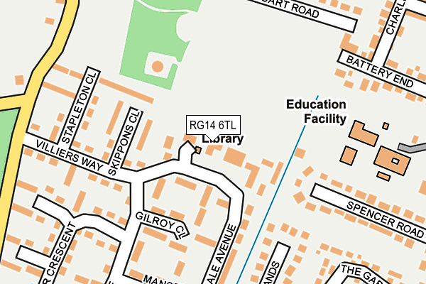
RG14 6TL is located in the Newbury Wash Common electoral ward, within the unitary authority of West Berkshire and the English Parliamentary constituency of Newbury. The Sub Integrated Care Board (ICB) Location is NHS Buckinghamshire, Oxfordshire and Berkshire West ICB - 15A and the police force is Thames Valley. This postcode has been in use since January 1991.


GetTheData
Source: OS OpenMap – Local (Ordnance Survey)
Source: OS VectorMap District (Ordnance Survey)
Licence: Open Government Licence (requires attribution)
| Easting | 445476 |
| Northing | 164684 |
| Latitude | 51.379391 |
| Longitude | -1.347955 |
GetTheData
Source: Open Postcode Geo
Licence: Open Government Licence
| Country | England |
| Postcode District | RG14 |
➜ See where RG14 is on a map ➜ Where is Newbury? | |
GetTheData
Source: Land Registry Price Paid Data
Licence: Open Government Licence
Elevation or altitude of RG14 6TL as distance above sea level:
| Metres | Feet | |
|---|---|---|
| Elevation | 120m | 394ft |
Elevation is measured from the approximate centre of the postcode, to the nearest point on an OS contour line from OS Terrain 50, which has contour spacing of ten vertical metres.
➜ How high above sea level am I? Find the elevation of your current position using your device's GPS.
GetTheData
Source: Open Postcode Elevation
Licence: Open Government Licence
| Ward | Newbury Wash Common |
| Constituency | Newbury |
GetTheData
Source: ONS Postcode Database
Licence: Open Government Licence
| Villiers Way | Wash Common | 163m |
| Villiers Way | Wash Common | 181m |
| Glendale Avenue Terminus (Glendale Avenue) | Wash Common | 185m |
| Meyrick Drive | Wash Common | 216m |
| Cary Close (Essex Street) | Wash Common | 373m |
| Newbury Station | 2.7km |
| Newbury Racecourse Station | 3.5km |
GetTheData
Source: NaPTAN
Licence: Open Government Licence
GetTheData
Source: ONS Postcode Database
Licence: Open Government Licence


➜ Get more ratings from the Food Standards Agency
GetTheData
Source: Food Standards Agency
Licence: FSA terms & conditions
| Last Collection | |||
|---|---|---|---|
| Location | Mon-Fri | Sat | Distance |
| Meyrick Drive | 17:30 | 12:00 | 254m |
| Monument | 17:30 | 12:00 | 604m |
| Malt House Farm | 16:00 | 09:15 | 1,346m |
GetTheData
Source: Dracos
Licence: Creative Commons Attribution-ShareAlike
The below table lists the International Territorial Level (ITL) codes (formerly Nomenclature of Territorial Units for Statistics (NUTS) codes) and Local Administrative Units (LAU) codes for RG14 6TL:
| ITL 1 Code | Name |
|---|---|
| TLJ | South East (England) |
| ITL 2 Code | Name |
| TLJ1 | Berkshire, Buckinghamshire and Oxfordshire |
| ITL 3 Code | Name |
| TLJ11 | Berkshire |
| LAU 1 Code | Name |
| E06000037 | West Berkshire |
GetTheData
Source: ONS Postcode Directory
Licence: Open Government Licence
The below table lists the Census Output Area (OA), Lower Layer Super Output Area (LSOA), and Middle Layer Super Output Area (MSOA) for RG14 6TL:
| Code | Name | |
|---|---|---|
| OA | E00082281 | |
| LSOA | E01016289 | West Berkshire 021A |
| MSOA | E02003387 | West Berkshire 021 |
GetTheData
Source: ONS Postcode Directory
Licence: Open Government Licence
| RG14 6TN | The Hampdens | 39m |
| RG14 6TQ | Glendale Avenue | 40m |
| RG14 6TG | Glendale Avenue | 69m |
| RG14 6TB | Lewis Walk | 112m |
| RG14 6TD | Phoenix Walk | 139m |
| RG14 6SE | Skippons Close | 145m |
| RG14 6SD | Goodwin Walk | 145m |
| RG14 6TA | Gilroy Close | 151m |
| RG14 6SA | Villiers Way | 173m |
| RG14 6SF | Stapleton Close | 180m |
GetTheData
Source: Open Postcode Geo; Land Registry Price Paid Data
Licence: Open Government Licence