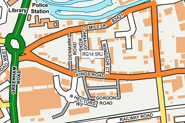
RG14 5RJ lies on Ashton Road in Newbury. RG14 5RJ is located in the Newbury Greenham electoral ward, within the unitary authority of West Berkshire and the English Parliamentary constituency of Newbury. The Sub Integrated Care Board (ICB) Location is NHS Buckinghamshire, Oxfordshire and Berkshire West ICB - 15A and the police force is Thames Valley. This postcode has been in use since January 1980.


GetTheData
Source: OS OpenMap – Local (Ordnance Survey)
Source: OS VectorMap District (Ordnance Survey)
Licence: Open Government Licence (requires attribution)
| Easting | 447611 |
| Northing | 166967 |
| Latitude | 51.399745 |
| Longitude | -1.316994 |
GetTheData
Source: Open Postcode Geo
Licence: Open Government Licence
| Street | Ashton Road |
| Town/City | Newbury |
| Country | England |
| Postcode District | RG14 |
➜ See where RG14 is on a map ➜ Where is Newbury? | |
GetTheData
Source: Land Registry Price Paid Data
Licence: Open Government Licence
Elevation or altitude of RG14 5RJ as distance above sea level:
| Metres | Feet | |
|---|---|---|
| Elevation | 80m | 262ft |
Elevation is measured from the approximate centre of the postcode, to the nearest point on an OS contour line from OS Terrain 50, which has contour spacing of ten vertical metres.
➜ How high above sea level am I? Find the elevation of your current position using your device's GPS.
GetTheData
Source: Open Postcode Elevation
Licence: Open Government Licence
| Ward | Newbury Greenham |
| Constituency | Newbury |
GetTheData
Source: ONS Postcode Database
Licence: Open Government Licence
| Gordon Road (Kings Road) | Newbury | 80m |
| Mill Lane | Newbury | 118m |
| Newbury Post Office (Cheap Street) | Newbury | 412m |
| Newbury Post Office (Cheap Street) | Newbury | 414m |
| Newbury Station (Station Road) | Newbury | 429m |
| Newbury Station | 0.5km |
| Newbury Racecourse Station | 0.7km |
GetTheData
Source: NaPTAN
Licence: Open Government Licence
| Percentage of properties with Next Generation Access | 100.0% |
| Percentage of properties with Superfast Broadband | 100.0% |
| Percentage of properties with Ultrafast Broadband | 0.0% |
| Percentage of properties with Full Fibre Broadband | 0.0% |
Superfast Broadband is between 30Mbps and 300Mbps
Ultrafast Broadband is > 300Mbps
| Percentage of properties unable to receive 2Mbps | 0.0% |
| Percentage of properties unable to receive 5Mbps | 0.0% |
| Percentage of properties unable to receive 10Mbps | 0.0% |
| Percentage of properties unable to receive 30Mbps | 0.0% |
GetTheData
Source: Ofcom
Licence: Ofcom Terms of Use (requires attribution)
GetTheData
Source: ONS Postcode Database
Licence: Open Government Licence


➜ Get more ratings from the Food Standards Agency
GetTheData
Source: Food Standards Agency
Licence: FSA terms & conditions
| Last Collection | |||
|---|---|---|---|
| Location | Mon-Fri | Sat | Distance |
| Kings Road | 17:30 | 12:00 | 40m |
| Sainsbury Store | 17:30 | 12:00 | 189m |
| The Wharf | 17:30 | 11:00 | 363m |
GetTheData
Source: Dracos
Licence: Creative Commons Attribution-ShareAlike
The below table lists the International Territorial Level (ITL) codes (formerly Nomenclature of Territorial Units for Statistics (NUTS) codes) and Local Administrative Units (LAU) codes for RG14 5RJ:
| ITL 1 Code | Name |
|---|---|
| TLJ | South East (England) |
| ITL 2 Code | Name |
| TLJ1 | Berkshire, Buckinghamshire and Oxfordshire |
| ITL 3 Code | Name |
| TLJ11 | Berkshire |
| LAU 1 Code | Name |
| E06000037 | West Berkshire |
GetTheData
Source: ONS Postcode Directory
Licence: Open Government Licence
The below table lists the Census Output Area (OA), Lower Layer Super Output Area (LSOA), and Middle Layer Super Output Area (MSOA) for RG14 5RJ:
| Code | Name | |
|---|---|---|
| OA | E00082574 | |
| LSOA | E01016348 | West Berkshire 019D |
| MSOA | E02003385 | West Berkshire 019 |
GetTheData
Source: ONS Postcode Directory
Licence: Open Government Licence
| RG14 5RG | Kings Road | 30m |
| RG14 5RH | Orts Road | 43m |
| RG14 5XE | Windsor Court | 45m |
| RG14 5SP | Connaught Road | 47m |
| RG14 5RA | Kings Road | 63m |
| RG14 5XG | Windsor Court | 67m |
| RG14 5SR | Denmark Road | 89m |
| RG14 5RE | Mill Lane | 101m |
| RG14 5RN | Gordon Road | 106m |
| RG14 5RX | Gordon Road | 109m |
GetTheData
Source: Open Postcode Geo; Land Registry Price Paid Data
Licence: Open Government Licence