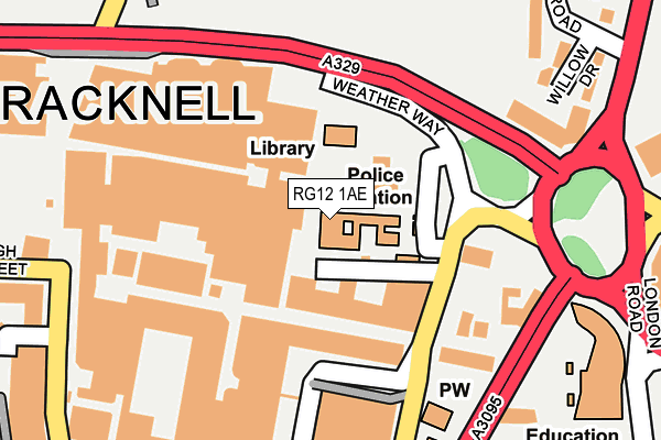
RG12 1AE is located in the Town Centre & The Parks electoral ward, within the unitary authority of Bracknell Forest and the English Parliamentary constituency of Bracknell. The Sub Integrated Care Board (ICB) Location is NHS Frimley ICB - D4U1Y and the police force is Thames Valley. This postcode has been in use since November 2016.


GetTheData
Source: OS OpenMap – Local (Ordnance Survey)
Source: OS VectorMap District (Ordnance Survey)
Licence: Open Government Licence (requires attribution)
| Easting | 487156 |
| Northing | 169432 |
| Latitude | 51.417215 |
| Longitude | -0.748037 |
GetTheData
Source: Open Postcode Geo
Licence: Open Government Licence
| Country | England |
| Postcode District | RG12 |
➜ See where RG12 is on a map ➜ Where is Bracknell? | |
GetTheData
Source: Land Registry Price Paid Data
Licence: Open Government Licence
Elevation or altitude of RG12 1AE as distance above sea level:
| Metres | Feet | |
|---|---|---|
| Elevation | 80m | 262ft |
Elevation is measured from the approximate centre of the postcode, to the nearest point on an OS contour line from OS Terrain 50, which has contour spacing of ten vertical metres.
➜ How high above sea level am I? Find the elevation of your current position using your device's GPS.
GetTheData
Source: Open Postcode Elevation
Licence: Open Government Licence
| Ward | Town Centre & The Parks |
| Constituency | Bracknell |
GetTheData
Source: ONS Postcode Database
Licence: Open Government Licence
| Police Station (The Ring) | Bracknell | 89m |
| The Ring - Parish Church (Charles Square Car Park) | Bracknell | 130m |
| The Ring - High Street (The Ring) | Bracknell | 312m |
| High Street | Bracknell | 313m |
| The Ring - High Street (The Ring) | Bracknell | 317m |
| Bracknell Station | 0.5km |
| Martins Heron Station | 2km |
GetTheData
Source: NaPTAN
Licence: Open Government Licence
GetTheData
Source: ONS Postcode Database
Licence: Open Government Licence


➜ Get more ratings from the Food Standards Agency
GetTheData
Source: Food Standards Agency
Licence: FSA terms & conditions
| Last Collection | |||
|---|---|---|---|
| Location | Mon-Fri | Sat | Distance |
| High Street Post Office | 18:30 | 12:15 | 111m |
| High Street P.o. Meter Box | 112m | ||
| Princess Square | 17:30 | 11:45 | 255m |
GetTheData
Source: Dracos
Licence: Creative Commons Attribution-ShareAlike
The below table lists the International Territorial Level (ITL) codes (formerly Nomenclature of Territorial Units for Statistics (NUTS) codes) and Local Administrative Units (LAU) codes for RG12 1AE:
| ITL 1 Code | Name |
|---|---|
| TLJ | South East (England) |
| ITL 2 Code | Name |
| TLJ1 | Berkshire, Buckinghamshire and Oxfordshire |
| ITL 3 Code | Name |
| TLJ11 | Berkshire |
| LAU 1 Code | Name |
| E06000036 | Bracknell Forest |
GetTheData
Source: ONS Postcode Directory
Licence: Open Government Licence
The below table lists the Census Output Area (OA), Lower Layer Super Output Area (LSOA), and Middle Layer Super Output Area (MSOA) for RG12 1AE:
| Code | Name | |
|---|---|---|
| OA | E00166677 | |
| LSOA | E01016249 | Bracknell Forest 007D |
| MSOA | E02003358 | Bracknell Forest 007 |
GetTheData
Source: ONS Postcode Directory
Licence: Open Government Licence
| RG12 1AA | High Street | 117m |
| RG12 1LL | High Street | 124m |
| RG12 1DU | High Street | 149m |
| RG12 1EA | High Street | 167m |
| RG12 2HX | Willow Drive | 266m |
| RG12 2HY | Grange Road | 291m |
| RG12 2TN | Kelvin Gate | 304m |
| RG12 2JA | Warfield Road | 332m |
| RG12 2HZ | Grange Road | 360m |
| RG12 2TG | Kelvin Gate | 370m |
GetTheData
Source: Open Postcode Geo; Land Registry Price Paid Data
Licence: Open Government Licence