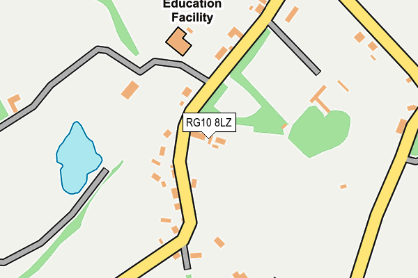
RG10 8LZ is located in the Remenham, Wargrave and Ruscombe electoral ward, within the unitary authority of Wokingham and the English Parliamentary constituency of Maidenhead. The Sub Integrated Care Board (ICB) Location is NHS Buckinghamshire, Oxfordshire and Berkshire West ICB - 15A and the police force is Thames Valley. This postcode has been in use since June 1998.


GetTheData
Source: OS OpenMap – Local (Ordnance Survey)
Source: OS VectorMap District (Ordnance Survey)
Licence: Open Government Licence (requires attribution)
| Easting | 479919 |
| Northing | 180727 |
| Latitude | 51.519818 |
| Longitude | -0.849550 |
GetTheData
Source: Open Postcode Geo
Licence: Open Government Licence
| Country | England |
| Postcode District | RG10 |
➜ See where RG10 is on a map ➜ Where is Crazies Hill? | |
GetTheData
Source: Land Registry Price Paid Data
Licence: Open Government Licence
Elevation or altitude of RG10 8LZ as distance above sea level:
| Metres | Feet | |
|---|---|---|
| Elevation | 90m | 295ft |
Elevation is measured from the approximate centre of the postcode, to the nearest point on an OS contour line from OS Terrain 50, which has contour spacing of ten vertical metres.
➜ How high above sea level am I? Find the elevation of your current position using your device's GPS.
GetTheData
Source: Open Postcode Elevation
Licence: Open Government Licence
| Ward | Remenham, Wargrave And Ruscombe |
| Constituency | Maidenhead |
GetTheData
Source: ONS Postcode Database
Licence: Open Government Licence
| Rose Lane Crossroads (Warren Row Road) | Warren Row | 631m |
| White Cliff (A321) | Wargrave | 1,466m |
| White Cliff (A321) | Wargrave | 1,478m |
| Summer Lodge (A321) | Wargrave | 1,609m |
| Summer Lodge (A321) | Wargrave | 1,614m |
| Shiplake Station | 2.5km |
| Wargrave Station | 3.1km |
| Henley-on-Thames Station | 3.9km |
GetTheData
Source: NaPTAN
Licence: Open Government Licence
GetTheData
Source: ONS Postcode Database
Licence: Open Government Licence


➜ Get more ratings from the Food Standards Agency
GetTheData
Source: Food Standards Agency
Licence: FSA terms & conditions
| Last Collection | |||
|---|---|---|---|
| Location | Mon-Fri | Sat | Distance |
| Lower Shiplake Post Office | 17:00 | 09:30 | 2,567m |
| Lashbrook | 16:00 | 07:00 | 2,855m |
| Old Bath Road | 16:45 | 08:30 | 2,908m |
GetTheData
Source: Dracos
Licence: Creative Commons Attribution-ShareAlike
The below table lists the International Territorial Level (ITL) codes (formerly Nomenclature of Territorial Units for Statistics (NUTS) codes) and Local Administrative Units (LAU) codes for RG10 8LZ:
| ITL 1 Code | Name |
|---|---|
| TLJ | South East (England) |
| ITL 2 Code | Name |
| TLJ1 | Berkshire, Buckinghamshire and Oxfordshire |
| ITL 3 Code | Name |
| TLJ11 | Berkshire |
| LAU 1 Code | Name |
| E06000041 | Wokingham |
GetTheData
Source: ONS Postcode Directory
Licence: Open Government Licence
The below table lists the Census Output Area (OA), Lower Layer Super Output Area (LSOA), and Middle Layer Super Output Area (MSOA) for RG10 8LZ:
| Code | Name | |
|---|---|---|
| OA | E00084172 | |
| LSOA | E01016677 | Wokingham 001C |
| MSOA | E02003439 | Wokingham 001 |
GetTheData
Source: ONS Postcode Directory
Licence: Open Government Licence
| RG10 8LY | 76m | |
| RG10 8PX | 150m | |
| RG10 8LU | 175m | |
| RG10 8LW | The Crescent | 291m |
| RG10 8QB | Hollycross | 368m |
| RG10 8NE | Hatchgate Lane | 415m |
| RG10 8NT | Cockpole Green | 542m |
| RG10 8QL | 597m | |
| RG10 8NJ | Upper Culham Road | 760m |
| RG10 8NL | Ashley Hill Place | 864m |
GetTheData
Source: Open Postcode Geo; Land Registry Price Paid Data
Licence: Open Government Licence