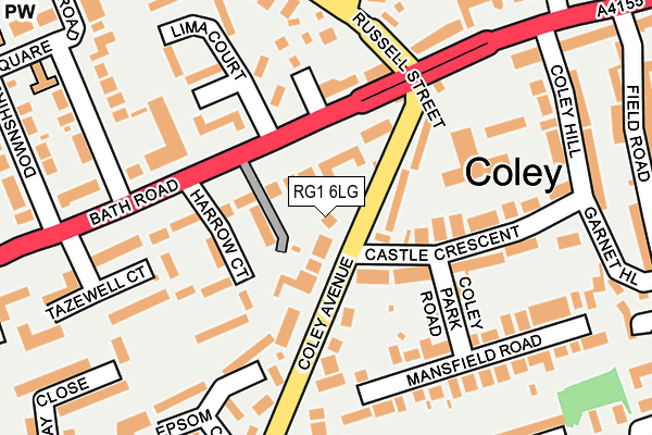
RG1 6LG lies on Coley Avenue in Reading. RG1 6LG is located in the Coley electoral ward, within the unitary authority of Reading and the English Parliamentary constituency of Reading West. The Sub Integrated Care Board (ICB) Location is NHS Buckinghamshire, Oxfordshire and Berkshire West ICB - 15A and the police force is Thames Valley. This postcode has been in use since January 1980.


GetTheData
Source: OS OpenMap – Local (Ordnance Survey)
Source: OS VectorMap District (Ordnance Survey)
Licence: Open Government Licence (requires attribution)
| Easting | 470719 |
| Northing | 172814 |
| Latitude | 51.449906 |
| Longitude | -0.983684 |
GetTheData
Source: Open Postcode Geo
Licence: Open Government Licence
| Street | Coley Avenue |
| Town/City | Reading |
| Country | England |
| Postcode District | RG1 |
➜ See where RG1 is on a map ➜ Where is Reading? | |
GetTheData
Source: Land Registry Price Paid Data
Licence: Open Government Licence
Elevation or altitude of RG1 6LG as distance above sea level:
| Metres | Feet | |
|---|---|---|
| Elevation | 60m | 197ft |
Elevation is measured from the approximate centre of the postcode, to the nearest point on an OS contour line from OS Terrain 50, which has contour spacing of ten vertical metres.
➜ How high above sea level am I? Find the elevation of your current position using your device's GPS.
GetTheData
Source: Open Postcode Elevation
Licence: Open Government Licence
| Ward | Coley |
| Constituency | Reading West |
GetTheData
Source: ONS Postcode Database
Licence: Open Government Licence
2C, COLEY AVENUE, READING, RG1 6LG 2004 7 SEP £350,000 |
GetTheData
Source: HM Land Registry Price Paid Data
Licence: Contains HM Land Registry data © Crown copyright and database right 2025. This data is licensed under the Open Government Licence v3.0.
| Russell Street (Bath Road) | Castle Hill - Bath Road | 100m |
| Lima Court (A4 Bath Road) | Castle Hill - Bath Road | 102m |
| Russell Street (Tilehurst Road) | Castle Hill - Bath Road | 181m |
| Russell Street (Castle Hill) | Castle Hill - Bath Road | 215m |
| Russell Street | Castle Hill - Bath Road | 240m |
| Reading West Station | 0.8km |
| Reading Station | 1.3km |
| Tilehurst Station | 4km |
GetTheData
Source: NaPTAN
Licence: Open Government Licence
| Percentage of properties with Next Generation Access | 100.0% |
| Percentage of properties with Superfast Broadband | 100.0% |
| Percentage of properties with Ultrafast Broadband | 100.0% |
| Percentage of properties with Full Fibre Broadband | 0.0% |
Superfast Broadband is between 30Mbps and 300Mbps
Ultrafast Broadband is > 300Mbps
| Percentage of properties unable to receive 2Mbps | 0.0% |
| Percentage of properties unable to receive 5Mbps | 0.0% |
| Percentage of properties unable to receive 10Mbps | 0.0% |
| Percentage of properties unable to receive 30Mbps | 0.0% |
GetTheData
Source: Ofcom
Licence: Ofcom Terms of Use (requires attribution)
GetTheData
Source: ONS Postcode Database
Licence: Open Government Licence


➜ Get more ratings from the Food Standards Agency
GetTheData
Source: Food Standards Agency
Licence: FSA terms & conditions
| Last Collection | |||
|---|---|---|---|
| Location | Mon-Fri | Sat | Distance |
| Castle Cresent | 16:15 | 13:00 | 102m |
| Downshire Square | 17:00 | 14:30 | 174m |
| Coley Avenue | 16:30 | 13:00 | 271m |
GetTheData
Source: Dracos
Licence: Creative Commons Attribution-ShareAlike
The below table lists the International Territorial Level (ITL) codes (formerly Nomenclature of Territorial Units for Statistics (NUTS) codes) and Local Administrative Units (LAU) codes for RG1 6LG:
| ITL 1 Code | Name |
|---|---|
| TLJ | South East (England) |
| ITL 2 Code | Name |
| TLJ1 | Berkshire, Buckinghamshire and Oxfordshire |
| ITL 3 Code | Name |
| TLJ11 | Berkshire |
| LAU 1 Code | Name |
| E06000038 | Reading |
GetTheData
Source: ONS Postcode Directory
Licence: Open Government Licence
The below table lists the Census Output Area (OA), Lower Layer Super Output Area (LSOA), and Middle Layer Super Output Area (MSOA) for RG1 6LG:
| Code | Name | |
|---|---|---|
| OA | E00082789 | |
| LSOA | E01016390 | Reading 013C |
| MSOA | E02003401 | Reading 013 |
GetTheData
Source: ONS Postcode Directory
Licence: Open Government Licence
| RG1 6HH | Bath Road | 40m |
| RG1 6LH | Coley Avenue | 49m |
| RG1 6LJ | Coley Avenue | 54m |
| RG1 6HN | The Firs | 57m |
| RG1 6LQ | Coley Avenue | 94m |
| RG1 6AG | Castle Crescent | 105m |
| RG1 6NB | Bath Road | 126m |
| RG1 6JF | Bath Road | 128m |
| RG1 6AH | Coley Park Road | 144m |
| RG1 6PP | Coley Avenue | 148m |
GetTheData
Source: Open Postcode Geo; Land Registry Price Paid Data
Licence: Open Government Licence