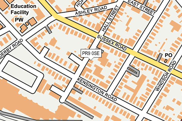
PR9 0SE lies on Hall Street in Southport. PR9 0SE is located in the Duke's electoral ward, within the metropolitan district of Sefton and the English Parliamentary constituency of Southport. The Sub Integrated Care Board (ICB) Location is NHS Cheshire and Merseyside ICB - 01V and the police force is Merseyside. This postcode has been in use since January 1980.


GetTheData
Source: OS OpenMap – Local (Ordnance Survey)
Source: OS VectorMap District (Ordnance Survey)
Licence: Open Government Licence (requires attribution)
| Easting | 334468 |
| Northing | 417103 |
| Latitude | 53.646326 |
| Longitude | -2.992806 |
GetTheData
Source: Open Postcode Geo
Licence: Open Government Licence
| Street | Hall Street |
| Town/City | Southport |
| Country | England |
| Postcode District | PR9 |
➜ See where PR9 is on a map ➜ Where is Southport? | |
GetTheData
Source: Land Registry Price Paid Data
Licence: Open Government Licence
Elevation or altitude of PR9 0SE as distance above sea level:
| Metres | Feet | |
|---|---|---|
| Elevation | 10m | 33ft |
Elevation is measured from the approximate centre of the postcode, to the nearest point on an OS contour line from OS Terrain 50, which has contour spacing of ten vertical metres.
➜ How high above sea level am I? Find the elevation of your current position using your device's GPS.
GetTheData
Source: Open Postcode Elevation
Licence: Open Government Licence
| Ward | Duke's |
| Constituency | Southport |
GetTheData
Source: ONS Postcode Database
Licence: Open Government Licence
| House Number 51 (Sussex Road) | Southport | 85m |
| Derby Rd (Sussex Road) | Southport | 87m |
| Ashley Rd (Sussex Road) | Southport | 106m |
| House Number 50 (Sussex Road) | Southport | 158m |
| Sussex Road (Derby Road) | Southport | 197m |
| Southport Station | 0.6km |
| Meols Cop Station | 1.1km |
| Birkdale Station | 2km |
GetTheData
Source: NaPTAN
Licence: Open Government Licence
| Percentage of properties with Next Generation Access | 100.0% |
| Percentage of properties with Superfast Broadband | 100.0% |
| Percentage of properties with Ultrafast Broadband | 25.4% |
| Percentage of properties with Full Fibre Broadband | 0.0% |
Superfast Broadband is between 30Mbps and 300Mbps
Ultrafast Broadband is > 300Mbps
| Median download speed | 39.1Mbps |
| Average download speed | 48.9Mbps |
| Maximum download speed | 159.99Mbps |
| Median upload speed | 9.8Mbps |
| Average upload speed | 9.9Mbps |
| Maximum upload speed | 30.02Mbps |
| Percentage of properties unable to receive 2Mbps | 0.0% |
| Percentage of properties unable to receive 5Mbps | 0.0% |
| Percentage of properties unable to receive 10Mbps | 0.0% |
| Percentage of properties unable to receive 30Mbps | 0.0% |
GetTheData
Source: Ofcom
Licence: Ofcom Terms of Use (requires attribution)
Estimated total energy consumption in PR9 0SE by fuel type, 2015.
| Consumption (kWh) | 542,459 |
|---|---|
| Meter count | 31 |
| Mean (kWh/meter) | 17,499 |
| Median (kWh/meter) | 13,702 |
| Consumption (kWh) | 98,698 |
|---|---|
| Meter count | 25 |
| Mean (kWh/meter) | 3,948 |
| Median (kWh/meter) | 3,817 |
GetTheData
Source: Postcode level gas estimates: 2015 (experimental)
Source: Postcode level electricity estimates: 2015 (experimental)
Licence: Open Government Licence
GetTheData
Source: ONS Postcode Database
Licence: Open Government Licence


➜ Get more ratings from the Food Standards Agency
GetTheData
Source: Food Standards Agency
Licence: FSA terms & conditions
| Last Collection | |||
|---|---|---|---|
| Location | Mon-Fri | Sat | Distance |
| 36 Kensington Road | 16:15 | 11:00 | 114m |
| Ashley Road | 16:15 | 11:15 | 157m |
| St Lukes | 17:45 | 11:30 | 223m |
GetTheData
Source: Dracos
Licence: Creative Commons Attribution-ShareAlike
The below table lists the International Territorial Level (ITL) codes (formerly Nomenclature of Territorial Units for Statistics (NUTS) codes) and Local Administrative Units (LAU) codes for PR9 0SE:
| ITL 1 Code | Name |
|---|---|
| TLD | North West (England) |
| ITL 2 Code | Name |
| TLD7 | Merseyside |
| ITL 3 Code | Name |
| TLD73 | Sefton |
| LAU 1 Code | Name |
| E08000014 | Sefton |
GetTheData
Source: ONS Postcode Directory
Licence: Open Government Licence
The below table lists the Census Output Area (OA), Lower Layer Super Output Area (LSOA), and Middle Layer Super Output Area (MSOA) for PR9 0SE:
| Code | Name | |
|---|---|---|
| OA | E00035328 | |
| LSOA | E01006969 | Sefton 004D |
| MSOA | E02001432 | Sefton 004 |
GetTheData
Source: ONS Postcode Directory
Licence: Open Government Licence
| PR9 0SR | Sussex Road | 66m |
| PR9 0SS | Sussex Road | 85m |
| PR9 0SB | Zetland Street | 122m |
| PR9 0RY | Kensington Road | 126m |
| PR9 0RE | Hall Street | 138m |
| PR9 0RT | Kensington Road | 139m |
| PR9 0SF | Hall Street | 145m |
| PR9 0RB | Ashley Road | 159m |
| PR9 0SP | Sussex Road | 183m |
| PR9 0TZ | Derby Road | 188m |
GetTheData
Source: Open Postcode Geo; Land Registry Price Paid Data
Licence: Open Government Licence