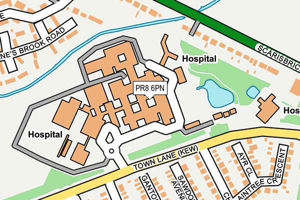
PR8 6PN is located in the Kew electoral ward, within the metropolitan district of Sefton and the English Parliamentary constituency of Southport. The Sub Integrated Care Board (ICB) Location is NHS Cheshire and Merseyside ICB - 01V and the police force is Merseyside. This postcode has been in use since February 1990.


GetTheData
Source: OS OpenMap – Local (Ordnance Survey)
Source: OS VectorMap District (Ordnance Survey)
Licence: Open Government Licence (requires attribution)
| Easting | 335373 |
| Northing | 415671 |
| Latitude | 53.633570 |
| Longitude | -2.978820 |
GetTheData
Source: Open Postcode Geo
Licence: Open Government Licence
| Country | England |
| Postcode District | PR8 |
➜ See where PR8 is on a map ➜ Where is Southport? | |
GetTheData
Source: Land Registry Price Paid Data
Licence: Open Government Licence
Elevation or altitude of PR8 6PN as distance above sea level:
| Metres | Feet | |
|---|---|---|
| Elevation | 10m | 33ft |
Elevation is measured from the approximate centre of the postcode, to the nearest point on an OS contour line from OS Terrain 50, which has contour spacing of ten vertical metres.
➜ How high above sea level am I? Find the elevation of your current position using your device's GPS.
GetTheData
Source: Open Postcode Elevation
Licence: Open Government Licence
| Ward | Kew |
| Constituency | Southport |
GetTheData
Source: ONS Postcode Database
Licence: Open Government Licence
| Southport Hospital (Town Lane) | Kew | 111m |
| Sawdon Avenue (Town Lane) | Kew | 137m |
| Southport Hospital | Kew | 176m |
| Kgv College (Scarisbrick New Road) | Kew | 222m |
| Althorpe Avenue (Southport Hospital) | Kew | 228m |
| Meols Cop Station | 1.4km |
| Southport Station | 2.1km |
| Birkdale Station | 2.4km |
GetTheData
Source: NaPTAN
Licence: Open Government Licence
GetTheData
Source: ONS Postcode Database
Licence: Open Government Licence


➜ Get more ratings from the Food Standards Agency
GetTheData
Source: Food Standards Agency
Licence: FSA terms & conditions
| Last Collection | |||
|---|---|---|---|
| Location | Mon-Fri | Sat | Distance |
| 1 Cheltenham Way | 16:30 | 11:30 | 186m |
| Ovington Drive Post Office | 17:45 | 11:30 | 477m |
| 1 Everard Road | 16:00 | 11:00 | 497m |
GetTheData
Source: Dracos
Licence: Creative Commons Attribution-ShareAlike
The below table lists the International Territorial Level (ITL) codes (formerly Nomenclature of Territorial Units for Statistics (NUTS) codes) and Local Administrative Units (LAU) codes for PR8 6PN:
| ITL 1 Code | Name |
|---|---|
| TLD | North West (England) |
| ITL 2 Code | Name |
| TLD7 | Merseyside |
| ITL 3 Code | Name |
| TLD73 | Sefton |
| LAU 1 Code | Name |
| E08000014 | Sefton |
GetTheData
Source: ONS Postcode Directory
Licence: Open Government Licence
The below table lists the Census Output Area (OA), Lower Layer Super Output Area (LSOA), and Middle Layer Super Output Area (MSOA) for PR8 6PN:
| Code | Name | |
|---|---|---|
| OA | E00035481 | |
| LSOA | E01006999 | Sefton 008C |
| MSOA | E02001436 | Sefton 008 |
GetTheData
Source: ONS Postcode Directory
Licence: Open Government Licence
| PR8 6JN | Ganton Close | 199m |
| PR8 6NU | Janes Brook Road | 213m |
| PR8 6HU | Sawdon Avenue | 224m |
| PR8 5NR | Cheltenham Way | 238m |
| PR8 5PA | Ayr Close | 243m |
| PR8 5NP | Cheltenham Way | 257m |
| PR8 5HL | Scarisbrick New Road | 266m |
| PR8 6NT | Janes Brook Road | 271m |
| PR8 6HS | Althorpe Drive | 289m |
| PR8 6LR | Scarisbrick New Road | 296m |
GetTheData
Source: Open Postcode Geo; Land Registry Price Paid Data
Licence: Open Government Licence