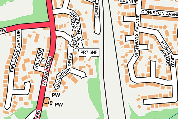
PR7 6NF is located in the Croston, Mawdesley & Euxton South electoral ward, within the local authority district of Chorley and the English Parliamentary constituency of Chorley. The Sub Integrated Care Board (ICB) Location is NHS Lancashire and South Cumbria ICB - 00X and the police force is Lancashire. This postcode has been in use since June 1998.


GetTheData
Source: OS OpenMap – Local (Ordnance Survey)
Source: OS VectorMap District (Ordnance Survey)
Licence: Open Government Licence (requires attribution)
| Easting | 355657 |
| Northing | 418158 |
| Latitude | 53.658038 |
| Longitude | -2.672451 |
GetTheData
Source: Open Postcode Geo
Licence: Open Government Licence
| Country | England |
| Postcode District | PR7 |
➜ See where PR7 is on a map ➜ Where is Pincock? | |
GetTheData
Source: Land Registry Price Paid Data
Licence: Open Government Licence
Elevation or altitude of PR7 6NF as distance above sea level:
| Metres | Feet | |
|---|---|---|
| Elevation | 50m | 164ft |
Elevation is measured from the approximate centre of the postcode, to the nearest point on an OS contour line from OS Terrain 50, which has contour spacing of ten vertical metres.
➜ How high above sea level am I? Find the elevation of your current position using your device's GPS.
GetTheData
Source: Open Postcode Elevation
Licence: Open Government Licence
| Ward | Croston, Mawdesley & Euxton South |
| Constituency | Chorley |
GetTheData
Source: ONS Postcode Database
Licence: Open Government Licence
2, DAISY HILL FOLD, EUXTON, CHORLEY, PR7 6NF 2020 14 DEC £475,000 |
DAISY HILL FARM, DAISY HILL FOLD, EUXTON, CHORLEY, PR7 6NF 2018 23 NOV £295,000 |
1, DAISY HILL FOLD, EUXTON, CHORLEY, PR7 6NF 1997 26 SEP £40,000 |
GetTheData
Source: HM Land Registry Price Paid Data
Licence: Contains HM Land Registry data © Crown copyright and database right 2025. This data is licensed under the Open Government Licence v3.0.
| Euxton Mills (Dawbers Lane) | Pincock | 165m |
| Euxton Mills (Dawbers Lane) | Pincock | 175m |
| Anderton Road (Wigan Road) | Euxton | 181m |
| Rail Station (Balshaw Lane) | Euxton | 337m |
| Rail Station (Balshaw Avenue) | Euxton | 337m |
| Euxton Balshaw Lane Station | 0.3km |
| Buckshaw Parkway Station | 1.9km |
| Chorley Station | 3.1km |
GetTheData
Source: NaPTAN
Licence: Open Government Licence
| Percentage of properties with Next Generation Access | 100.0% |
| Percentage of properties with Superfast Broadband | 100.0% |
| Percentage of properties with Ultrafast Broadband | 0.0% |
| Percentage of properties with Full Fibre Broadband | 0.0% |
Superfast Broadband is between 30Mbps and 300Mbps
Ultrafast Broadband is > 300Mbps
| Percentage of properties unable to receive 2Mbps | 0.0% |
| Percentage of properties unable to receive 5Mbps | 0.0% |
| Percentage of properties unable to receive 10Mbps | 0.0% |
| Percentage of properties unable to receive 30Mbps | 0.0% |
GetTheData
Source: Ofcom
Licence: Ofcom Terms of Use (requires attribution)
GetTheData
Source: ONS Postcode Database
Licence: Open Government Licence


➜ Get more ratings from the Food Standards Agency
GetTheData
Source: Food Standards Agency
Licence: FSA terms & conditions
| Last Collection | |||
|---|---|---|---|
| Location | Mon-Fri | Sat | Distance |
| Highways Post Office | 17:00 | 11:00 | 448m |
| 139 Wigan Road, Euxton | 16:15 | 11:00 | 480m |
| Common Bank Industrial Estate | 17:45 | 11:30 | 1,243m |
GetTheData
Source: Dracos
Licence: Creative Commons Attribution-ShareAlike
The below table lists the International Territorial Level (ITL) codes (formerly Nomenclature of Territorial Units for Statistics (NUTS) codes) and Local Administrative Units (LAU) codes for PR7 6NF:
| ITL 1 Code | Name |
|---|---|
| TLD | North West (England) |
| ITL 2 Code | Name |
| TLD4 | Lancashire |
| ITL 3 Code | Name |
| TLD47 | Chorley and West Lancashire |
| LAU 1 Code | Name |
| E07000118 | Chorley |
GetTheData
Source: ONS Postcode Directory
Licence: Open Government Licence
The below table lists the Census Output Area (OA), Lower Layer Super Output Area (LSOA), and Middle Layer Super Output Area (MSOA) for PR7 6NF:
| Code | Name | |
|---|---|---|
| OA | E00126745 | |
| LSOA | E01024971 | Chorley 005E |
| MSOA | E02005193 | Chorley 005 |
GetTheData
Source: ONS Postcode Directory
Licence: Open Government Licence
| PR7 6NE | Dunrobin Drive | 89m |
| PR7 6HZ | Wigan Road | 107m |
| PR7 6JD | Wigan Road | 131m |
| PR7 6JA | Anderton Road | 161m |
| PR7 6NW | Regency Gardens | 163m |
| PR7 6PA | Highways Avenue | 167m |
| PR7 6JB | Hillside Close | 185m |
| PR7 6QD | Highways Avenue | 209m |
| PR7 6LP | Wigan Road | 228m |
| PR7 6JF | Fieldside Avenue | 245m |
GetTheData
Source: Open Postcode Geo; Land Registry Price Paid Data
Licence: Open Government Licence